Download
1 / 51
510 likes | 608 Views
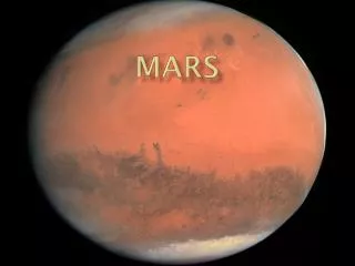
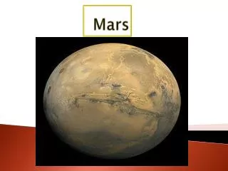
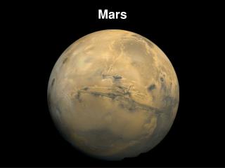
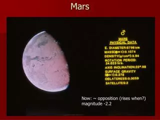
Mars. R = 3394 km M = 6.42 x 10 23 kg R orbit = 1.082 x 10 8 km T = 180-270º K Eccentricity = 0.093 Axial tilt = 23.98 º “day” = 1.026 days “year” = 1.88 years orbital inclination = 1.85º. R = 0.53 R M = 0.11 M R orbit = 1.52 A.U. Vital Statistics. A bit of background.

E N D
R = 3394 km M = 6.42 x 10²³ kg Rorbit = 1.082 x 10⁸ km T = 180-270º K Eccentricity = 0.093 Axial tilt = 23.98 º “day” = 1.026 days “year” = 1.88 years orbital inclination = 1.85º R = 0.53 R M =0.11M Rorbit = 1.52 A.U. Vital Statistics
A bit of background • The “red” planet • Known since prehistoric times • Lowell thought he saw canals, which led to LOTS of Sci-Fi • Roman god Mars was a god of agriculture before becoming associated with the Greek Ares (who was the god of War)
Claims to fame • Sports the largest volcano in the Solar System • We’ve sent more landers to Mars than anywhere else in the Solar System • (Note: Mars’ orbit is eccentric enough to affect its seasons.)
Probes: Landers • Mars 2 • Viking I and II • Mars Pathfinder (see replica upstairs) • Mars Expedition Rovers, Spirit and Opportunity • Many others
Probes: Orbiters • Mariner 4 • Mars Global Surveyor • Odyssey • Mars Express • Others
Mariner 4 • Sister probe to Mariner 3, whose protective shield failed to eject • First probe to reach Mars - Flew by in 1965 • Took 22 images of Martian surface • Found a cratered world with an atmosphere much thinner than previously thought: object lesson • May have concluded the general change in SF from alians on Mars to dwellers on planets in other Star Systems
Mariner 4 images The first closeup image ever taken of Mars
Viking I and II • Each had both an orbiter and a lander • Arrived summer of ‘76 • V. I showed that Mars’ sky is pinkish, not dark blue as was previously thought • V. I searched for micro-organisms - found? • V. I sent back great color panoramas • V. II seismometer worked, and recorded one marsquake
Viking pictures First image that Viking I sent back (yes, that’s its foot
Viking pictures This image was aquired at the Viking Lander 1 site.The large rock just left of the center is about 2 m wide, and was named “Big Joe” by Viking scientitsts. The top is covered with red soil. The portions not covered with soil are similar to basaltic rocks here on Earth.
Viking 1 landing site This image was taken by the Mars Reconnaissance Orbiter on Dec. 5, 2006.
Mars Reconnaissance Orbiter (MRO) • Goals: Determine whether life ever arose on Mars, characterize climate of Mars, characterize geology of Mars, prepare for human exploration • Launched in 1995, now orbiting • Set the record for most data sent back in a single day
Mars Reconnaissance Orbiter (MRO) Erosion has exposed light-toned, layered rocks on the northern rim of Hellas Basin, the largest impact crater on Mars. Details in the layering seen in this image from the High-Resolution Imaging Science Experiment (HiRISE) reveal variations in brightness that may indicate differing mineralogies.
Mars Global Surveyor (MGS) • Launched Nov 1996 • Went silent in Nov 2006 due to a battery failure (caused by a complex sequence of events) • Orbited 12 times per day
MGS • Monitored long-term cycles and variability of the martian atmosphere and volatile systems • Characterized the solid planet, including surface areas of geological importance and improvements in knowledge of internal structure • Support for future Mars missions, including landing site assessment, relaying data, etc.
MGS Topographic depression eroded into layered rocks. Erosion has revealed layers of different ages - the oldest are at the bottom of the depression. Within this depression are two sets of alluvial - that is, water-lain - sedimentary rock units that retain their original shape, indicating how the sediments were deposited long before the material became rock. In these cases, the processes created fans of debris with finger-like protrusions at the ends and sides of the fans. Aslo preserved are the channels through which water and sediment flowed.
Structure (?) • Dense core about 1700km in radius, molten rocky mantle somewhat denser that Earth’s then a thin crust (crust is 80 km thick in southern hemisphere, but only 35 km thick in north) • Lacks plate techtonics, so hot spots (and low surface gravity) make BIG volcanoes • No current tectonic activity, but there probably was in the past
Atmosphere • 95.3 % CO2 (tiny amount compared to what it once had) • 2.7% N2 • 1.6% Ar • traces of O2 (0.15%) and water (0.03%)
History • Was more like Earth • most of CO2 was absorbed into rocks, but since it has no plate techtonics, it can’t recycle CO2 back into its atmosphere (no greenhouse effect to keep it warm) • Had running water once, maybe it’s all below the surface now? • Probably had a large ocean • Northern hemisphere “younger” than southern
Inset is Grand Canyon, to scale Valles Marineris - 4000km long, 7km deep, and 120 km wide
a) Crater on the moon - powder ejecta b) Crater on Mars - liquid “splosh”
Our view has become better with time. a) Ground-based view b) HST c) Viking image
A comparison with the Red River running from Shreveport, LA, to the Mississippi. The Martian channel is about 400 km long and 5 km wide.
Gullies apparently formed by running water in the recent past (MGS)
a) As the Sun’s light reaches and heats the canyon floor, it drives water vapor from the surface. When this vapor comes in contact with the coler air above the surface, it condenses again, and a temporary water-ice “fog” results. b) This is the 200-km-wide Lowell Crater, as seen by MGS.
Deimos (panic) Radius = 11 km
Phobos (fear) Radius = 9 km