Download
1 / 12
130 likes | 298 Views
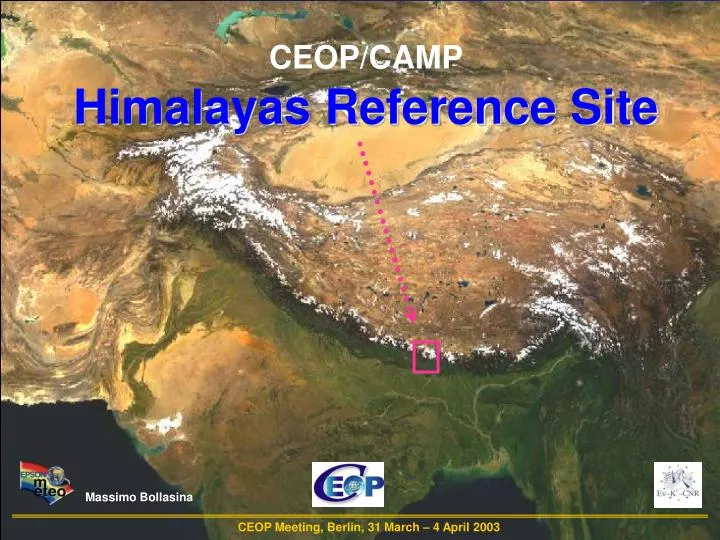
CEOP/CAMP Himalayas Reference Site. Massimo Bollasina. CEOP Meeting, Berlin, 31 March – 4 April 2003. Location: the Khumbu Valley. CEOP/CAMP – HIMALAYAS Reference Site. Pyramid (5035 m). 36. Pheriche (4260 m). 28. Syangboche (3833 m). Distance (km). 14. Namche (3570 m). 0.

E N D
CEOP/CAMP Himalayas Reference Site Massimo Bollasina CEOP Meeting, Berlin, 31 March – 4 April 2003
Location: the Khumbu Valley CEOP/CAMP – HIMALAYAS Reference Site Pyramid (5035 m) 36 Pheriche (4260 m) 28 Syangboche (3833 m) Distance (km) 14 Namche (3570 m) 0 Lukla (2660 m) 9 km
The Pyramid MeteoNetwork (hourly data) CEOP/CAMP – HIMALAYAS Reference Site Pyramid Pheriche Namche Installed in October 2000 Implemented in September 2002 Lukla Installed in October 2001 Available from 1 October 2002 Installed in Octoberl 2001 Installed in November 2002 Available from 2 November 2002
Syangboche AWS (20 minute data) Parameter Sensor Type Accuracy Height of measurement (m) Air Temperature Platinum Resistor 0.1°C 3 Precipitation Tipping Bucket 0.5 mm 1 Relative Humidity Hygrophiber 3% 3 Atmospheric Pressure Silicon Chip 0.2 hPa 3 Wind Speed 3-cup anemometer 2% 3 Wind Direction Potentiometer 5° 3 Downward short wave Radiation Temperature Difference 2 mW/cm2 3 Upward short wave Radiation Temperature Difference 2 mW/cm2 3 Soil temperature Platinum Resistor 0.1°C 0.05 Soil temperature Platinum Resistor CEOP/CAMP – HIMALAYAS Reference Site 0.1°C 0.15 Syangboche Installed in October 1994 (GEN)
Recent Improvements (1/2) CEOP/CAMP – HIMALAYAS Reference Site Pyramid AWS implementation Snow depth 4 component radiation Sub surface sensors
Recent Improvements (2/2) CEOP/CAMP – HIMALAYAS Reference Site AWS installation in Lukla Toward North Toward South
Data Collection and Format (1/2) CEOP/CAMP – HIMALAYAS Reference Site Data download: Spring and Autumn, sent by email to Italy (PMN) Yearly, end of Summer (SYAN) (better send 6 months data to CDA) Data type: ASCII, separated by semicolon (PMN) ASCII, separated by comma (SYAN)
Data Collection and Format (2/2) Data format (PMN): # hourly: instantaneous, minimum, mean, maximum, std. deviation - with time # daily: > instantaneous, minimum, mean, maximum, std. deviation > statistics (wind speed and direction) CEOP/CAMP – HIMALAYAS Reference Site Data format (SYAN): # instantaneous
AWSs Functioning • Routine check: local personnel (daily/weekly): • check sensors, AWS functioning; • read data and send data report to Italy every two weeks (PMN) Spare sensors: at Lukla (bottom) and the Pyramid (top) CEOP/CAMP – HIMALAYAS Reference Site
Future Plans CEOP/CAMP – HIMALAYAS Reference Site Main task: AWS Network maintenance Future cooperation is essential to: Overcome severe conditions Further improve obervations at the Pyramid (possible developments include more sub-surface observations, near-surface measurements (e.g., latent and sensible heat fluxes)
Questions CEOP/CAMP – HIMALAYAS Reference Site Hour of recording (UTC/NST: UTC=NST- 5.45 hrs) -> daily summary Data compensated for altitude (air density) Comparison with MOLTS (orography)
Himalayas ref. site contribution to CEOP CEOP/CAMP – HIMALAYAS Reference Site Analysis of summer monsoon onset Precipitation distribution along the southeastern slope of the Himalayas Relation between large-scale circulation and local wind system Long term climate monitoring in high-altitude mountain areas Surface heat budget and relation with development, maintenance and variability of summer monsoon VERIFICATION WITH MODEL OUTPUT (analysis and simulation)