Download
1 / 10
100 likes | 166 Views
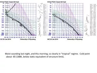
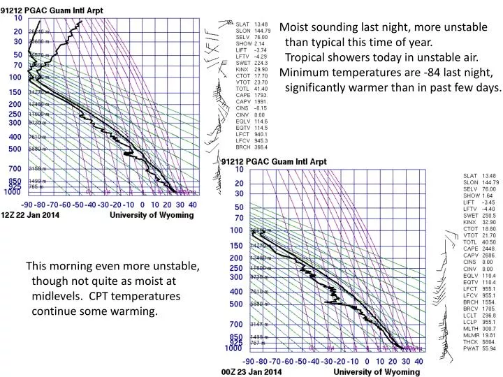
Moist sounding last night, more unstable than typical this time of year. Tropical showers today in unstable air. Minimum temperatures are -84 last night, significantly warmer than in past few days. This morning even more unstable, though not quite as moist at

E N D
Moist sounding last night, more unstable than typical this time of year. Tropical showers today in unstable air. Minimum temperatures are -84 last night, significantly warmer than in past few days. This morning even more unstable, though not quite as moist at midlevels. CPT temperatures continue some warming.
Can see small showers to the SE moving north. Tropical system is now near 20N and interacting with developing wave and associated front to the northwest. Can see convection developing along front, but no lightning as yet.
Low pressure system ahead of the shear line leading to southerlies at this time (14 knots gusting to 20 –OOL). This is more than anticipated. Position of front is good.
Near TO. As front/shear line moves closer (and the low), winds shift to SW. Tail winds Near the 10 knot limit. Showers possible
Front advances, putting us closer to low center and reducing mean winds from the SW somewhat. NWS calling for slight chance of thunder. This needs to be watched, call GH back early maybe.
At 28kft, see a break in the moisture, so I think we are OK on icing for tomorrow.
Red is where we start to worry about turbulence, but there is a strong STJ (38kft) developing in association with the front, leading to stronger shears. Just be watchful.
Coldest temperatures at 53kft have retreated to the SE, but developing trough is producing colder temperatures to the NW (below). This is a dynamic situation developing during the flight. Best viewed with Leslie’s animation.
Frontal passage Saturday, significant rain in my opinion and gusty winds. We are at the edge of the strong northeasterlies at 4 PM on Saturday. Looks like rain on TO, and strong northeasterlies on landing.
Sunday may be another day of high winds from the northeast. Rain chances go down.