Download
1 / 30
310 likes | 523 Views
NASIS. NATIONAL SOIL INFORMATION SYSTEM -- AN OVERVIEW. WHAT IS NASIS?. NASIS is the NRCS’ National Soil Information System NASIS is one part of NRCS resource information system NASIS is a set of soil survey concepts NASIS is a data management system (software )

E N D
NASIS NATIONAL SOIL INFORMATION SYSTEM -- AN OVERVIEW
WHAT IS NASIS? • NASIS is the NRCS’ National Soil Information System • NASIS is one part of NRCS resource information system • NASIS is a set of soil survey concepts • NASIS is a data management system (software) • NASIS is a user interface software
Public Data CustomerProducts Field Data Collection Plant Data Lab Manage Soil Data Soil Survey Report Manuscript text Pedon NASIS Soil Data SSURGO Range Analyze/ Summarize Forest CST Climate Data Soil Map FOTG DOQs Crops Custom Reports
WHY NASIS ? • The need to be able to deliver data in a timely manner • The need to improve data integrity, quality, and consistency • The need to modify the data base as new soil properties become a priority
NASIS Concepts -- Soil Tax., Interps NSSH, SSM, Spatial Database Point Data -- Lab Data Pedon Desc. Map Unit Data (aggregated data) NASIS Concepts“National Soil Information System”
NRCS Information System NASIS PLANTS Ecological Sites Climate Data DOQs Other
NASIS • Captures point data • Aggregates point data to component data • Interprets components • Captures a map unit concept • Manages Projects • Publishes Legends • Schedules and manages soil survey activities
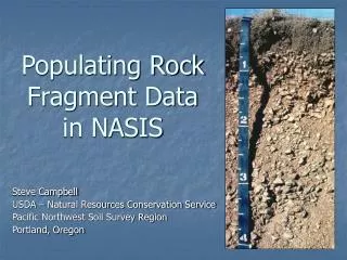
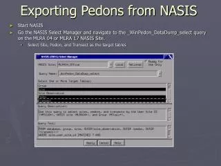
NASIS Pedon Concepts • Input - NASIS provides capability to enter pedon descriptions, transect data, field notes and observations • Import - import data from PedonPC and previously PDP 3.x data were converted into NASIS (~ 95K pedons 11/00) (~420K 1/12) • Import – ability to append selected pedon data using spreadsheets
NASIS Pedon Concepts • Report - available to generate pedon descriptions • Analysis - reports to summarize data • Consistency – Site/Pedon tables use same choice lists as Map Unit/Component tables • Pedons are linked to Components (Component Pedon) and Sites are linked to Map units (Site Map unit overlap)
NASIS Area/Legend Concepts • A survey area is independent of its legend • Geographical area overlaps of soil survey areas of areas can be recorded and map units assigned to those areas • Historical soil survey information - area, legend, and map unit - are recorded
NASIS Map Unit Concepts • Map units can have unlimited components • Components can have unlimited horizons • Soil property ranges are not limited to series – but its RV values are. • Components are either “major” or “minor”
NASIS Map Unit Concepts • Map Unit “Component” – the lowest level spatial entity for which a range of soil property data is stored. It has known extent, but unknown spatial location, except by its relative topographic position within the map unit.
NASIS Map Unit Concepts • Flooding, ponding, and soil moisture are annual events in which data are recorded by month in which it commonly occurs
NASIS Component Concepts • Horizons can be identified by horizon nomenclature -- Ap, Bt1, etc. • Representative values can be designated for many soil properties, as well as high and low values. • Interpretation criteria can be developed to meet local needs
NASIS Concepts • Component or pedon level data can be run through the interpretation generator to get interpretive results.
NASIS Security Concepts • Tables – organization of data elements pertinent to one object • Objects – grouping of tables in a parent-child relationship with similar data needs • Users are assigned to security Groups • Data objects can be owned and managed by the Groups to protect data and restricts edit privileges
NASIS - data management • NASIS is aimed at soil scientists who develop and manage soil data, not for public access to data • NASIS national database exists on a central data server • software resides on the local computer • all users login to the same location (KC) • facilitates sharing of data
NASIS - data management • NASIS contains data for soil map units and components, pedon descriptions, Soil Survey Schedule, and STATSGO • NASIS includes the capability to generate interpretations on data using a new process -- fuzzy logic • Exports data to Soil Data Warehouse and Soil Data Mart
NASIS - data management • NASIS provides capability to : • add/delete data • search database • interpret data • report data and interpretation results • edit data • calculate and validate data • ensure data integrity • export data
NASIS - data management • NASIS software does not enforce program policy or procedures • NASIS software does not make correlation decisions - humans do • NASIS software is a data management tool
Site Observ. date Lab data Pedon Descriptions Veg data - range, crop, forest Soil temp & moisture Photos Transects Other
eFOTG Soil Data Warehouse and Data Mart Resource Data Gateway On-line Soil Surveys Electronic Soil Surveys Resource Data Viewer Soil Data Viewer Web Soil Data Viewer Spatial Data (Dig Units) Soil Data Mart(s) Soil Data Warehouse Soil Staging Server NASIS Transaction Database Web Services/API Pedon LIMS NRI Models & Applications -- RUSLE2, WinPST, WEPS, etc
WHO USES NASIS? • Soil scientists at all levels of soil survey • Survey staff- legends and map unit data, manuscripts, documentation • State office - providing data to users -- FOTG, SSURGO, interpretations, etc. • MLRA Regional staff - quality assurance, correlation process • National office - tracking of progress, national data queries