Download
1 / 38
480 likes | 974 Views
------Using GIS--. NR 143/385. INTRODUCTION TO GPS. Global Positioning Systems GPS. Lecture by Robert Long, University of Vermont Many materials for this lecture adapted from Trimble Navigation Ltd’s GPS Web tutorial

E N D
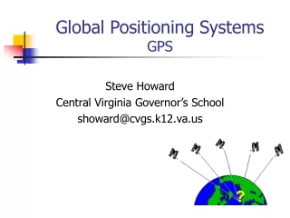
------Using GIS-- NR 143/385 INTRODUCTION TO GPS Global Positioning Systems GPS Lecture by Robert Long, University of Vermont Many materials for this lecture adapted from Trimble Navigation Ltd’s GPS Web tutorial at http://trimble.com/gps/index.html as well as from lectures originally prepared by Austin Troy, Gerald Livingston, and Leslie Morrissey
GPS • What is it? • How does it work? • Errors and Accuracy • Ways to maximize accuracy • System components
GPS • Stands for Global Positioning System • GPS is used to get an exact location on or above the surface of the earth (1cm to 100m accuracy). • Developed by DoD and made available to public in 1983. • GPS is a very important data input source.
GPS Uses • Trimble Navigation Ltd., breaks GPS uses into five categories: • Location – positioning things in space • Navigation – getting from point a to point b • Tracking - monitoring movements • Mapping – creating maps based on those positions • Timing – precision global timing
GPS Uses • The uses for GPS mapping are enormous. Here are just a few examples: • Centerlines of roads • Hydrologic features (over time) • Bird nest/colony locations (over time) • Fire perimeters • Trail maps • Geologic/mining maps • Vegetation and habitat
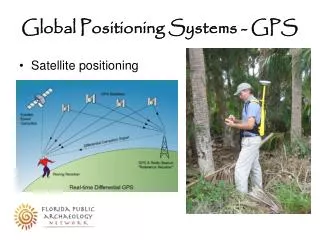
GPS • GPS is a worldwide radio-navigation system formed from 24 satellites and their ground stations. • Satellites orbit earth every 12 hours at approximately 20,200 km • GPS uses satellites in space as reference points for locations here on earth • Ground stations help satellites determine their exact location in space. • Hawaii • Ascension Island • Diego Garcia • Kwajalein • Colorado Springs
12,500 km 11,200 km 11,500 km How does GPS work? • GPS derives position relative to satellite “reference points,” using triangulation • The GPS unit on the ground figures out its distance to each of several satellites
How Does GPS Work? • We need at least 3 satellites as reference points to “triangulate” our position.
How Does GPS Work? Sphere Concept Source: Trimble Navigation Ltd. A fourth satellite narrows it from 2 possible points to 1 point
How Does GPS Work? • This method assumes we can find exact distance from our GPS receiver to a satellite. HOW??? • Simple answer: see how long it takes for a radio signal to get from the satellite to the receiver. • We know speed of light, but we also need to know: Distance = Velocity * Time • When the signal left the satellite • When the signal arrived at the receiver
How Does GPS Work? • The difficult part is measuring travel time • This gets complicated when you think about the need to perfectly synchronize satellite and receiver.
How Does GPS Work? • To do this requires comparing lag in exactly similar patterns, one from satellite and one from receiver. • This code has to be extremely complex (hence almost random), so that patterns are not linked up at the wrong place on the code. Source: Trimble Navigation Ltd.
How Does GPS Work? • The code also has to be generated from each source at exactly the same time. • So, the satellites have expensive atomic clocks that keep perfect time—that takes care of their end. • But what about the ground receiver?
How Does GPS Work? • Here is where the fourth satellite signal comes in. • While 3 perfect satellite signals can give a perfect location, 3 imperfect signals can’t, but 4 can • Remember the sphere example… • If receiver clock is correct, 4 circles should meet at one point. If they don’t meet, the computer knows there is an error in the clock: “ They don’t add up”
How Does GPS Work? • A fourth satellite allows a correction factor to be calculated that makes all circles meet in one place. • This correction is used to update the receiver’s clock.
How Does GPS Work? • The receiver then knows the difference between its clock’s time and universal time and can apply that to future measurements. • Of course, the receiver clock will have to be resynchronized often , because it will lose or gain time
Accuracy Depends On: • Time spent on measurements • Location • Design of receiver • Relative positions of satellites • Use of differential techniques
Sources of Error • Gravitational effects • Atmospheric effects • Obstruction • Multipath • Satellite geometry • Selective Availability
Errors and Accuracy (cont.) • Gravitational pull of other celestial bodies on the satellite, affecting orbit • Atmospheric effects - signals travel at different speeds through ionosphere and troposphere. • Both of these errors can be partly dealt with using predictive models of known atmospheric behavior and by using Differential GPS. Source: Trimble Navigation Ltd.
Errors and Accuracy (cont.) • Obstruction - Signal blocked or strength reduced when passing through objects or water. • Weather • Metal • Tree canopy • Glass or plastic • Microwave transmitters • Multipath – Bouncing of signals may confuse the receiver.
Errors and Accuracy (cont.) • Satellite Constellation Geometry • Number of satellites available • Elevations or azimuths over time Positional Dilution of Precision (P.D.O.P.)
Satellite 1 Satellite 1 Satellite 2 Satellite 2 High PDOP Low PDOP Errors and Accuracy (cont.) • PDOP • Indicator of satellite geometry • Accounts for location of each satellite relative to others • Optimal accuracy when PDOP is LOW
Locating Satellites • We know how far we are from the satellites, but how do we know where the satellites are? • Because the satellites are 20,000 km up, they operate according to the well understood laws of physics, and are subject to few random, unknown forces. • This allows us to know where a satellite should be at any given moment. • Also tracked by radar to measure slight deviations from predicted orbits.
Locating Satellites (cont.) • This location information (ephemeris) is relayed to the satellite, which transmits the info when it sends its pseudo random code. • There is also a digital “almanac” on each GPS receiver that tells it where a given satellite is supposed to be at any given moment. • Other information is relayed along with the radio signal: time-of-day, quality control info.
Errors and Accuracy (cont.) • Selective Availability (S.A.) • Until May of 2000, the DoD intentionally introduced a small amount of error into the signal for all civilian users. • SA resulted in about 100 m error most of the time • Turning off SA reduced error to about 30 m radius
Ensuring Accurate Locations • Adequate satellites • Low PDOP (≤ 4 excellent, 5-8 acceptable) • Averaging • Clear weather • Minimize multipath error • Use open sites • Appropriate planning (ephemeris, skyplots) > USE DIFFERENTIAL GPS
Differential GPS • Increase accuracy dramatically • This was used in the past to overcome Selective Availability (100m to 4-5m) • DGPS uses one stationary and one moving receiver to help overcome the various errors in the signal • By using two receivers that are nearby each other, within a few dozen km, they are getting essentially the same errors (except receiver errors)
INTRODUCTION TO GPS Differential GPS • DGPS improves accuracy much more than disabling of SA does • This table shows typical error—these may vary Source: http://www.furuno.com/news/saoff.html
How does DGPS work? • The stationary receiver must be located on a known control point • The stationary unit works backwards—instead of using timing to calculate position, it uses its position to calculate timing
How does DGPS work? • Can do this because, precise location of stationary receiver is known, and hence, so is location of satellite • Once it knows error, it determines a correction factor and sends it to the other receiver.
How does DGPS work? • Message sent to rover with correction factor for all satellites. • More reference stations becoming available.
Other DGPS Concepts • Real-time vs. Post-processing • Wide Area Augmentation System (WAAS)
System Components • Receiver • Receives satellite signals • Compiles location info, ephemeris info, clock calibration, constellation configuration (PDOP) • Calculates position, velocity, heading, etc… • Data Collector • Stores positions (x,y,z,t) • Attribute data tagged to position • Software • Facilitates file transfer to PC and back • Performs differential correction (post-processing) • Displays data and permits file editing.
15m System Components - Receivers • Course/Acquisition (C/A) Code Receivers • Civilian grade • Use info in satellite signals to calculate position • 12-40m CEP* without differential correction • <1-5m CEP with differential correction • Do not need to maintain constant communication (lock) with satellites • Can be used under forest canopy CEP: 50% of positions are within a horizontal circle of a radius equal to the specified length.
System Components - Receivers • Carrier Phase (P-Code) Receivers • Military or survey grade • Uses actual radio signal to calculate position • ± 1cm SEP* (50% of locations within sphere of this radius) • Must record positions continuously from at least 4 satellites for at least 10 minutes – requires clear view • Number of Channels • 4 satellites for accurate 3D positions, 5 or more for highest accuracy • 9-12 satellites required to track all visible satellites at given moment
Review • What is it? • How does it work? • Errors and Accuracy • Ways to maximize accuracy • System components