Download
1 / 17
170 likes | 328 Views
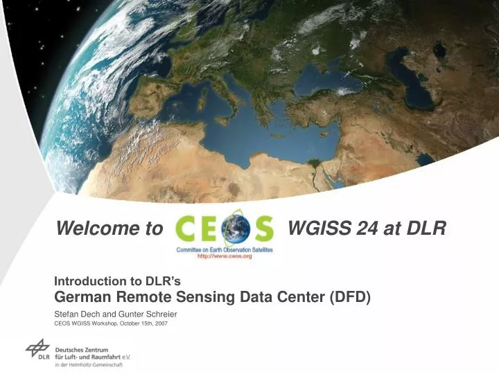
Welcome to CEOS WGISS 24 at DLR Introduction to DLR’s German Remote Sensing Data Center (DFD). Stefan Dech and Gunter Schreier CEOS WGISS Workshop, October 15th, 2007. Hamburg. Neustrelitz. Berlin- Charlottenburg . Trauen . Braunschweig n. Berlin- - n Adlershof.

E N D
Welcome to CEOS WGISS 24 at DLRIntroduction to DLR’sGerman Remote Sensing Data Center (DFD) Stefan Dech and Gunter SchreierCEOS WGISS Workshop, October 15th, 2007
Hamburg Neustrelitz Berlin- Charlottenburg Trauen Braunschweign Berlin-- n Adlershof nGöttingen nKöln-Porz nBonn Sankt Augustin Darmstadt nLampoldshausen nStuttgart n Oberpfaffenhofen Weilheim The German Aerospace Center (DLR) Largest R&D institution in Germany 30 Institutes at 8 sites and 7 field offices Space Agency of the Federal Republic of Germany 5200 staff, 2500 scientists, 500 PhD students 1150 staff in Oberpfaffenhofen Aeronautics Space R&D Space Agency Transport Energy
DFD – At a Glance • Founded in 1980, 180 staff (2007) in 7 Departments • 24 million € revenue (2006) • Core activities: • National, ESA, and industrial ground segment operations • Operation of EUMETSAT satellite application facility elements • Germany’s Remote Sensing data library • Data management developments • Development of value-added product and service chains • International application projects • Dedicated Cross-cutting user services for Atmosphere, Emergency Response, Geovisualization • 2 DLR locations in Germany In Oberpfaffenhofen near Munich…
DFD Worldwide Station Network PermanentNeustrelitz (Germany) 3 LSX-band 7.3 m, LS-band 4.0 m, VHFOberpfaffenhofen (Germany) X-band 3.6 m, L-band 2.4 m, L-band 4.0 m X-band (5,6 m) on behalf of European Space Imaging O‘Higgins (Antarctic) LSX-band 9.0 m Chetumal (Mexico) LSX-band 9.0 m Transportable Ny Álesund (with GFZ, Spitzbergen) X-band 4.0 m MobileRecife (Brazil) L-band 0.9 m
DFD Ground Segment Services • In Neustrelitz: high data rate missions and real-time services over Europe • Champ, Grace,BIRD, EnMAP (national) • ERS-1, ERS-2, Envisat(national) • Koronas-F (national), Maroc/Tubsat (national) • TerraSAR-X , TanDEM-X (national/Infoterra GmbH) • IRS-1C/IRS-1D (Euromap), IRS-P3 (Euromap, national) • IRS-P6 (ResourceSat),IRS-P5 (CartoSat) (Euromap) • Orbview-2 (Orbimage) • Rapid Eye(DLR-Space Agency, scientific data management for DLR data) • ALOS (ESA-Earthnet; commissioning) • Landsat-5/7 (ESA-Earthnet) • In Oberpfaffenhofen: low data rate missions and PAF/PAC functions • NOAA, Metop(national) • Meteosat, MSG(national) • Oceansat-1 (IRS-P4) (national) • ERS, Envisat PAF/PAC (ESA) • Terra,Aqua(national, ESA) • IKONOS (European Space Imaging) • International stations: dedicated missions, and commercial customers • ERS-2, Landsat-5/7, IRS-1C/D, NOAA, Champ, BIRD, Terra, Aqua, Envisat, TerraSAR-X
Data management, archiving, distribution • Long term archival of all German mission data in the National Remote Sensing Data Library (NRSDL) • Established EOWEB gateway & working on improved access to archive data through geodata browser for the GIS-community Data and Information Management System (DIMS) as the kernel of a multi-mission payload data ground segment Cooperation with industry on further development and international projects (e.g. EUMETSAT SAF) Supporting ESA to harmonize and setting standardsfor the ground segments in Europe
High-Tech Thermometer GRIPS 3 Atmosphere and Climate
Acquisition Processing Data-Management Ecosystems, Environment Climate, Atmosphere Security, Disaster Mapping DFD – Merging technical and scientific expertise Payload Data Ground Segment Applications and Services Ensuring access and log-term preservation to remote sensing data and geoinformation Innovation thru product-oriented research, development, and value adding Research, technology, products, and services for the benefit of society …serving scientific, industrial, governmental, and public needs
DLR-DFD in line with overall CEOS goals • Creation of EO data products for the global demands • Simplification of access to EO data products with an interoperable, modular and easily extensible infrastructure • Promotion of EO data products use in science, commerce and society (the latter with focus on humanitarian relief/disaster management) • Long term preservation of our assets to improve the scientific and economic value of time series • Contributing to CEOS WGD / WGISS tasks and projects since its beginning
DLR and CEOS CEOS established 1984 Working Group on Data since 1985 DLR is CEOS member since 1986 Starting with contributions to WGD since 1987 • - CEOS SAR Data Format • - IDN Cooperating Node • - CEOS Information Locator Service (CILS) • - Catalog Interoperability Experiment (CINTEX) • Global Land One Km Base Elevation (GLOBE) • WGISS DSTT (OGC/ISO TC211) From CEOS Newsletter #1, 1993