Download
1 / 7
70 likes | 250 Views
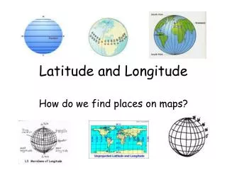
Latitude and Longitude. Latitude. Lines of latitude are used to determine how far north or south a location is from the Equator. The Equator is an imaginary line that circles the Earth at its widest point. The Equator is 0 degrees latitude.

E N D
Latitude • Lines of latitude are used to determine how far north or south a location is from the Equator. • The Equator is an imaginary line that circles the Earth at its widest point. • The Equator is 0 degrees latitude. • The Equator is halfway between the North and South Poles. • The Equator divides the Earth into to halves called hemispheres. • Locations north of the Equator are in the Northern Hemisphere and locations south of the Equator are in the Southern Hemisphere.
Latitude • Lines of latitude are also called parallels because they are parallel to each other. • This means that they never cross. • Lines of latitude are always written as degrees north or south of the Equator. • Latitude, or distance from the Equator, determines the climate of a location. • The farther from the Equator the hotter, and the closer to the Equator the colder.
Longitude • Lines of longitude measure how far east or west a location is from the Prime Meridian. • The Prime Meridian is an imaginary line that runs through Greenwich, England. • It divides the Earth into two hemispheres. • Locations west of the Prime Meridian are in the Western Hemisphere and locations east of the Prime Meridian are in the Eastern Hemisphere.
Longitude • Lines of longitude do not circle the Earth because they start and end at the poles. • Lines of Longitude meet or converge at the North and South Poles. • The International Date Line is on the opposite side of the world from the Prime Meridian. • The International Dateline is 180 degrees longitude.
Longitude • The International Dateline is the beginning point for counting time and dates of earth. • Lines of longitude also divide the world into time zones. • The United States has 6 different time zones. • Georgia is in the Eastern Time Zone.
Latitude & Longitude • Together latitude and longitude are the system used to find absolute location. • The absolute location of Atlanta is approximately 33 degrees N, 85 degrees W.