Download
1 / 1
10 likes | 85 Views
0°. 0°. 0°. 0°. 0°. 0°. 0°. 0°. 0°. 0°. 0°. 0°. 48. 48. 48. 48. 36. 36. 36. 36. 10°S. 10°S. 10°S. 10°S. 10°S. 10°S. 10°S. 10°S. 10°S. 10°S. 10°S. 10°S. 24. 24. 24. 24. 12. 12. 12. 12. 0. 0. 0. 0. 20°S. 20°S. 20°S. 20°S. 20°S. 20°S. 20°S. 20°S.

E N D
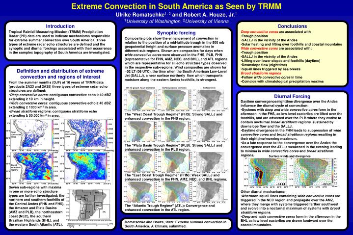
0° 0° 0° 0° 0° 0° 0° 0° 0° 0° 0° 0° 48 48 48 48 36 36 36 36 10°S 10°S 10°S 10°S 10°S 10°S 10°S 10°S 10°S 10°S 10°S 10°S 24 24 24 24 12 12 12 12 0 0 0 0 20°S 20°S 20°S 20°S 20°S 20°S 20°S 20°S 20°S 20°S 20°S 20°S -12 -12 -12 -12 -24 -24 -24 -24 30°S 30°S 30°S 30°S 30°S 30°S 30°S 30°S 30°S 30°S 30°S 30°S -36 -36 -36 -36 -48 -48 -48 -48 [m] [m] [m] [m] 40°S 40°S 40°S 40°S 40°S 40°S 40°S 40°S 40°S 40°S 40°S 40°S 80°W 80°W 80°W 80°W 80°W 80°W 80°W 80°W 80°W 80°W 80°W 80°W 70°W 70°W 70°W 70°W 70°W 70°W 70°W 70°W 70°W 70°W 70°W 70°W 60°W 60°W 60°W 60°W 60°W 60°W 60°W 60°W 60°W 60°W 60°W 60°W 50°W 50°W 50°W 50°W 50°W 50°W 50°W 50°W 50°W 50°W 50°W 50°W 40°W 40°W 40°W 40°W 40°W 40°W 40°W 40°W 40°W 40°W 40°W 40°W 30°W 30°W 30°W 30°W 30°W 30°W 30°W 30°W 30°W 30°W 30°W 30°W 0° 0° 10°S 10°S 20°S 20°S 30°S 30°S 80°W 70°W 60°W 50°W 40°W [Probability] 80°W 70°W 60°W 50°W 40°W [mm d-1] 40°S 40°S 80°W 70°W 60°W 50°W 40°W 30°W [km] 0 1 2 3 5 7 0.5 0.75 0.25 Extreme Convection in South America as Seen by TRMM Ulrike Romatschke1, 2 and Robert A. Houze, Jr.11University of Washington, 2University of Vienna Introduction Conclusions Tropical Rainfall Measuring Mission (TRMM) Precipitation Radar (PR) data are used to indicate mechanisms responsible for extreme summer convection over South America.Three types of extreme radar echo structures are defined and the synoptic and diurnal forcings associated with their occurrence in the complex topography of South America are investigated. Synoptic forcing • Deep convective coresare associated with • Trough position • SALLJ in the vicinity of the Andes • Solar heating and lifting over foothills and coastal mountains • Wide convective coresare associated with: • Trough position • SALLJ in the vicinity of the Andes • Lifting over lower slopes and foothills (daytime) • Downslope flow (nighttime) • Squall lines triggered by sea breeze • Broad stratiform regions • Follow wide convective cores in time • Coincide with climatological precipitation maxima Composite plots show the enhancement of convection in relation to the position of a mid-latitude trough in the 500 mb geopotential height and surface pressure anomalies in different sub-regions. Shown are composites for days when wide convective cores were observed in the FHS, PLB, FHN (representative for FHN, AMZ, NEC, and BHL), and ATL regions which are representative for all echo structure types observed in the respective sub-regions. Wind composites are shown for ~02 LT (06 UTC), the time when the South American Low-Level Jet (SALLJ), a near surface northerly flow which transports moisture along the eastern Andes foothills, is strongest. Definition and distribution of extreme convection and regions of interest • From the summer months (DJF) of 10 years of TRMM data (products 2A23 and 2A25) three types of extreme radar echo structures are defined: • Deep convective cores: contiguous convective echo ≥ 40 dBZ extending ≥ 10 km in height. • Wide convective cores: contiguous convective echo ≥ 40 dBZ extending ≥1000 km2 in area. • Broad stratiform regions: contiguous stratiform echo extending ≥50,000 km2 in area. 500 mb geopot. height anomalies Surface pressure anomalies Surface winds 4.8 3.6 Diurnal Forcing 2.4 1.2 0 • Daytime convergence/nighttime divergence over the Andes influence the diurnal cycle of convection: • Systems with deep and wide convective cores form in the afternoon in the FHS, as low-level easterlies are lifted over the foothills, and are advected over the PLB where they evolve to contain nocturnal broad stratiform regions, sustained by downslope flow and the SALLJ. • Daytime divergence in the FHN leads to suppression of wide convective cores and broad stratiform regions resulting in their nighttime/morning maximum. • As a late response to the convergence over the Andes the convergence over the ATL is weakened in the evening leading to minima in wide convective cores and broad stratiform regions. -1.2 -2.4 -3.6 -4.8 10 ms-1 [mb] The “West Coast Trough Regime” (FHS): Strong SALLJ and enhanced convection in the FHS region. 0.0072 0.0072 4.8 5°S 5°S 0.006 0.006 3.6 2.4 1.2 0.0048 0.0048 0 15°S 15°S Wide convective cores Deep convective cores -1.2 0.0036 0.0036 -2.4 -3.6 25°S 25°S 0.0024 0.0024 -4.8 10 ms-1 [mb] dBZ 0.0012 0.0012 11°S The “Plata Basin Trough Regime” (PLB): Strong SALLJ and enhanced convection in the PLB region. 35°S 35°S 0 0 12 80°W 70°W 60°W 50°W 40°W [Probability] 80°W 70°W 60°W 50°W 40°W [Probability] 0.036 21 4.8 3.6 Surface winds and divergence 5°S 5°S 18 13 2.4 0.03 3.6 1.2 15 0 2.7 0.024 -1.2 14 15°S 15°S 12 1.8 Broad stratiform regions -2.4 0.018 126 127 128 129 130 131 132 -3.6 0.9 Precip. 9 -4.8 10 ms-1 20 [mb] 0 25°S 25°S 0.012 Millimeter Cloud Radar 6 28 -0.9 The “East Coast Trough Regime” (FHN): Weak SALLJ and enhanced convection in the FHN, AMZ, NEC, and BHL regions. 16 21 0.006 3 -1.8 12 35°S 35°S -2.7 0 0 8 [s-1] 4.8 ~14 LT ~02 LT 3.6 4 Seven sub-regions with maxima in one or more echo structure types are further investigated: the northern and southern foothills of the Central Andes (FHN and FHS), the Amazon and Plata Basins (AMZ and PLB),the northeastern coast (NEC), the southern Brazilian Highlands (BHL), and the western South Atlantic (ATL). 10 ms-1 2.4 80°W 70°W 60°W 50°W 40°W 1.2 0 • Other diurnal mechanisms: • Afternoon squall lines containing wide convective cores are triggered in the NEC region and propagate over the AMZ, where they merge with systems triggered farther southwest and evolve into a nocturnal maximum of systems with broad stratiform regions. • Deep and wide convective cores form in the afternoon in the BHL as low-level easterlies are drawn landward over the coastal mountains. 0 19 Jan22:00 20 Jan00:00 20 Jan02:00 20 Jan04:00 -28 NEC -1.2 Time -2.4 AMZ -3.6 -4.8 FHN 10 ms-1 [mb] The “Atlantic Trough Regime” (ATL): Convergence and enhanced convection in the ATL region. BHL PLB ATL FHS Romatschke and Houze, 2009: Extreme summer convection in South America. J. Climate, submitted.