Download

1 / 19
270 likes | 1.34k Views
Bukidnon River Watersheds: The Headwaters of Six (6) Major Rivers in Mindanao by : Governor Alex P. Calingasan. Province of Bukidnon. Province of Bukidnon. Geographic Facts and Figures : Total Land Area: 1,049,859 hectares Land Classification: Alienable & Disposable 36%

E N D
Bukidnon River Watersheds: The Headwaters of Six (6) Major Rivers in Mindanao by: Governor Alex P. Calingasan
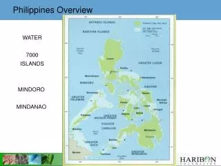
Province of Bukidnon Province of Bukidnon Geographic Facts and Figures: Total Land Area: 1,049,859 hectares Land Classification: Alienable & Disposable 36% Forestland 64% Number of Cities: 2 Number of Municipalities – 20 Population ( 2007 Census):: 1,190,284 Major Watersheds: 6 (Pulangui, Tagoloan, Cagayan, Maridugao, Davao Salug, Agusan- Cugman) Tribal Communities: 7 tribes (Talaandig, Higaonon, Bukidnon, Umayamnon, Matigsalug, Manobo, Tigwahanon) Protected Areas: Mt. Kitanglad Range Natutal Park - 24,802 hectares Mt. Kalatungan Range Natural Park - 31,236 hectares Land Cover (2005): 25% natural forest, 34 % plantation and wooded land, 23 % grassland, 17 % perrenial crops Geographic Facts and Figures:
Why the Province of Bukidnon adopted watershed management approach for Sustainable Development
Mt. Kimangkil MacaJALAR Bay SIX (6) MAJOR RIVERS WATERSHED IN BUKIDNON Malitbog AGUSAN DEL NORTE Cagayan de Oro Mt. Tago Range ManoloFortich Pantaron Mt. Range • Pulangui River which traverses the province from Kalabugao plain in the North and rains to the southwest of Mindanao through the Cotabato Provinces. Its watershed divides into two(2) clusters: Upper and Lower Pulangui. There are nine(9) municipalities in the Upper Pulangui watershed while Lower Pulangui is also spread in the nine(9) municipalities. Baungon Libona Sumilao LANAO DEL NORTE Imapsugong Talakag Mt. Kitanglad Range • Tagoloan Riverthat emanates from the East-central part in the plateau areas around Malaybalay and drains Northward toward Macajalar Bay in Tagoloan, Misamis Oriental Province. Its watershed extends into five(5) municipalities. Lantapan Cabanglasan Mt. Kalatungan Range • Cagayan Riverthat comes from the mountains of Talakag (Northwest of Bukidnon) and also drains northward into the Macajalar Bay in Cagayan de Oro City, Misamis Oriental Province. The watershed covers three(3) municipalities of the Province. Valencia City San Fernando LANAO DEL SUR Lake lanao Pangantukan Maramag Mt. Tangkulang Range • Maridugao Riverthat flows from the mountains of Talakag and drains Southward forming the natural boundary between Bukidnon and Lanao del Sur Provinces. The watershed is composed of five(5) municipalities. Kalilangan Don Carlos Quezon Kadingilan Kitaotao • Davao-Salug Riverthat cuts the Eastern fringes of the province along the mountains of San Fernando and drains south towards Davao Province. San Fernando and Quezon municipalities make up its watershed. Dangcagaqn Kibawe Damulog • Agusan-Cugman Riverthat originates from Kitanglad mountains which cuts through the Municipality of Libona and drains into Macajalar Bay Cagayan de Oro City, Province of Misamis Oriental. The watershed covers two(2) municipalities in Bukidnon. DAVAO CITY NORTH COTABATO
Bukidnon River Watersheds and Municipalities/ Cities Covered Agusan-Cugman Tagoloan Cagayan Upper Pulangui Maridugao Davao-Salug Lower Pulangui
TYPES OF WATERSHEDS: 4 River Basin 1 Large Watershed 2 Medium Watershed 17 Small Watershed More than 155 Micro Watershed Tagoloan Agusan-Cugman Cagayan Upper Pulangui Maridugao Davao-Salug Lower Pulangui
Environmental Sustainabilty: Biodiversity Conservation (Forest and wetland ecosystems) in the following provinces: • Bukidnon-Existing protected areas Mt. Kitanglad & Mt. Kalatungan Range Nature Parks & proposed protected areas: Mt. Tangkulan, Mt. Saldab, Mt. Tago and Pantaron Ranges. • 2. Liquasan Marsh declared as Game refuge and Bird Sanctuary and a home of more than 112,000 Maguindanao families whose primary means of livelihood are fishing; • 3. Agusan Marsh, a Wildlife Sanctuary which have been also designated as one of the RAMSAR sites in the Philippines and included in the list of Wetlands of International Importance (RAMSAR TREATY) being the refuge and nesting area of migratory bird species,Soil Conservation, Water conservation, flood mitigation, carbon sequestration, oxygen generation and micro climate amelioration. Role of Bukidnon River Watersheds As Headwaters • Economics Sustainability: Hydro-electric Power (NAPOCOR - that generates 255MW, 30% of the power demand in Mindanao, Bobonawan Power Company and First Gen Power Corporation; Water Supply for Bukidnon-1.3 Million people,16 Agrobusiness (Banana,pineapple, sugar cane, High Value crops etc.) & 32,382 hectares irrigated lands,145,434 annual and perennial croplands & 191 poultry’s & piggeries and economic activities of adjoining provinces. Of more than 5 million people
Social and Economic Sustainability: Food Security & Water Supply for more than____ peiople: Eco-cultural and Landscape preservation), Recreation (hike trekking, mountain climbing and water sports), Historical (protection of historical monuments and archeological sites), Cultural (Protection of areas of cultural importance e.g sacred groves, burial places, indigenous cultures, beliefs and knowledge, and Social Welfares (livelihood security, social equity/poverty alleviation, reduction of risk of loss of life due to natural disasters, disaster relief avoidance , prevention of rural and urban migration. Role of Bukidnon River Watersheds
Rapid increase of population and slash and burn have caused rapid denudation in the upland areas, particularly in the last two decades. 2005 spot revealed that Bukidnon’s forest cover is only 25% situated in the headwater mountain slopes resulted also with a corresponding decline in genetic species and ecosystem within and downstream watershed. • Rapid rainfall runoff and severe soil erosion became increasingly evident as flash flood, landslides and siltation in the rainy season alternated with worsening droughts and destructive fires in the dry season when inadequate river flows failed to sustain irrigation and hydro-electric power generation. • Competing water uses by different group of users • Degrading water quality and decreasing water quantity • Extent of rural poverty in the uplands continued to increase and the ability of upland farm families to generate even subsistence livelihoods from the deteriorating resource base continue to decline. • Agricultural intensification that leads the conversion of forestlands to agricultural lands. Local,Public & Modellers Ecological Knowledge on Watershed Issues
Bukidnon River Watersheds ManaqementInitiatives 1. Facilitated the issuance of Memorandum Order 270, in 1985, Creating the Bukidnon Watershed Protection and Development Council, signed by then President Fidel V. Ramos in order to protect the remaining forests within BukidnonRivers Watersheds; 2) Enacted and enforced logging moratorium since 1986. • 3) Conducted comprehensive database establishment to determine the macro to micro river watersheds as one of the basesfor watershed management in the Provincial, City/ Municipal up to Barangay level (1995- to date). 4) Provincial, City and Municipaland pilot Barangay watershed management plans were formulated by diverse body of stakeholders as framework in environmental and natural resources management coupled with the conduct of capacity development. 5) Facilitated Provincial Watershed forums and summit to integrate various environmental and natural resources management programs, projects and activities. 4) Implemented reforestation, small scale tree farms and tree growing by applying Rewards of Environmental Services. 5. Enacted the Bukidnon Environment Code. 5) Enacted a resolution to support the declaration of Mt. Ktanglad Range Nature Park and Mt. Kalatungan Range Nature Park as Protected areas.
Deforestation and forest Degradation (caused by population and economic growth) have caused rapid denudation in the upland areas, particularly in the last two decades. 2005 spot revealed that Bukidnon’s forest cover is only 25% situated in the headwater mountain slopes resulted also with a corresponding decline in genetic species and ecosystem within and downstream watershed. • Rapid rainfall runoff and severe soil erosion became increasingly evident as flash flood, landslides and siltation in the rainy season alternated with worsening droughts and destructive fires in the dry season when inadequate river flows failed to sustain irrigation and hydro-electric power generation. • Competing water uses by different group of users • Degrading water quality and decreasing water quantity • Extent of rural poverty in the uplands continued to increase and the ability of upland farm families to generate even subsistence livelihoods from the deteriorating resource base continue to decline. • Agricultural intensification that leads the conversion of forestlands to agricultural lands. Local,Public & Modellers Ecological Knowledge on Watershed Issues
WATERSHED MANAGEMENT CAPABILITY BUILDING & PLANNING PROGRAM OF LGUs ( Provincial , Municipal & Barangay) 1995-up to 1998 Bukidnon Major Watersheds
WATERSHED MANAGEMENT CAPABILITY BUILDING & PLANNING PROGRAM OF LGUs ( Municipal &) 1998-2006
WATERSHED MANAGEMENT CAPABILITY BUILDING & PLANNING PROGRAM OF LGUs ( Barangay 2006-to date
Approach in watershed Data based Collection, Interpretation and Analysis Impact Pathways Address Communication Gap between three types of Knowledge on Watershed Functions and found appropriate Negotiations for Payment or Rewards of environmental Services Local Ecological Knowledge Public Ecological Knowledge Scientific Ecological Knowledge Figure. 1. Integration of three Sources of Knowledge System ( Local, Public and Scientific Domains for Sustainable Dev’t.
On- going Watershed Management Programs, Projects and Activities Institutional Management : • Strengthening of Bukidnon Watershed Protection and Development Council, 6 Major River Watersheds Management Boards, Bukidnon River Basin Forum, City/Municipal Technical Working Groups and Pilot Barangay Working Groups. • Watershed Management Capacity Development and Planning for the formulation of 6 Major River Watershed Framework Plans, 155 Barangay Watershed management plans and updating of city/municipal watershed plans • Strengthening links with diverse body of stakeholders with the adjacent provinces particularly on river basin particularly on planning and policy making) for iwatershed management (ridge to rift collaboration and for realization of Payment of Environmental Services (PES) for sustainable development. Policy and Legislation • Revision of Bukidnon Environment Code and finalization of Implementing Rules and Regulations (IRR).
On- going Watershed Management Programs, Projects and Activities Technology/ Project Interventions: • Implementation of Bukidnon Greening Program through adopting Rewards of Environmental Services ( rehabilitation of 3,000 has. protection and production forestlands and riparian zones CY 2011-2013) through the establishment of 6 CBFM Model sites within 6 major river watersheds; Establishment of 487 Protected Areas and Tree Parks within the Provincial, Municipal and Barangay level; rehabilitation of 50 hectares riparian zones, Upland Poverty Reduction Support Program –livelihood and Educational Support Project) and reforestation and afforestation projects . • Intensification of National Greening Program • Strengthening protection and rehabilitation of Mt. Kitanglad Range Nature Park and Mt. Kalatungan Range Nature Park for Biodiversity Conservation. • Research and Development on REDD & Payment of Environmental Services (PES), • Implementation of Negotiation Support Tools: for Rapid Hydrological Assessment, Carbon Stocks Assessment, Biodiversity Conservation, Upland Market Appraisal, Tenure Market Appraisal. and participatory landscape appraisal for Integrated Natural Resources Management .
Institutional Challenges: • Strengthen inter-provinces watershed capacity development and management planning • Continuing IEC program in watershed resource management. and Implementation of Comprehensive Training Programme • Creation of ENROs ( City & Municipal level). • Investment /Budget for ENR Programs and projects • Developing Watershed Champions among stakeholders • Establishment of Management Information System. • Latest Spatial and Temporal Data ( e.g. satellite images) • Local Policy & Legislation Challenges: • Harmonization of Major Environmental laws (Republic Act and Executive Order, & Ordinance) • Enforcement of national and local ENR policies rules and regulations particularly on landuses • Integration of Payment of Environmental Services in Local Ordinance • Technological Challenges : • Research and Development on REDD and Payment of Environmental Services • Integration of Local, Public and Scientific Ecological knowledge for ENR program and • Project conceptualization and implementation. • Integration of climate change adaptation and mitigation measures