Download
1 / 34
340 likes | 450 Views
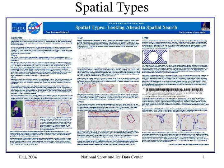
Spatial Types. Point Data. Sparse Point Data. Dense Point Data. Gridded Data. MODIS CMG - Coverage. SSM/I Ease-grid. SSM/I EASE Grid - Coverage. Polar Stereo (Sea Ice). Polar Stereo (Sea Ice) - Coverage. Polar Stereo (Sea Ice) - Coverage. Polar Stereo (Sea Ice) - Coverage.

E N D
Spatial Types National Snow and Ice Data Center
Point Data National Snow and Ice Data Center
Sparse Point Data National Snow and Ice Data Center
Dense Point Data National Snow and Ice Data Center
Gridded Data National Snow and Ice Data Center
MODIS CMG - Coverage National Snow and Ice Data Center
SSM/I Ease-grid National Snow and Ice Data Center
SSM/I EASE Grid - Coverage National Snow and Ice Data Center
Polar Stereo (Sea Ice) National Snow and Ice Data Center
Polar Stereo (Sea Ice) - Coverage National Snow and Ice Data Center
Polar Stereo (Sea Ice) - Coverage National Snow and Ice Data Center
Polar Stereo (Sea Ice) - Coverage National Snow and Ice Data Center
Polar Stereo (Sea Ice) - Coverage National Snow and Ice Data Center
Polar Stereo (Sea Ice) - Coverage National Snow and Ice Data Center
Polar Stereo (Sea Ice) - Coverage National Snow and Ice Data Center
Tiles National Snow and Ice Data Center
05v08h Coverage National Snow and Ice Data Center
05v08h w/ lat/lon bounding box National Snow and Ice Data Center
05v08h Spherical National Snow and Ice Data Center
AVHRR L1b (Scene) National Snow and Ice Data Center
AVHRR L1b (Scene) - Coverage National Snow and Ice Data Center
AVHRR L1b (Scene) - Coverage National Snow and Ice Data Center
AVHRR L1b (Scene) - Coverage National Snow and Ice Data Center
AVHRR L1b (Scene) - Coverage National Snow and Ice Data Center
AVHRR L1b (Scene) - Coverage National Snow and Ice Data Center
Weird Shape National Snow and Ice Data Center
Full Orbit - Coverage National Snow and Ice Data Center
Full Orbit - LLBox National Snow and Ice Data Center
Full Orbit – Lat/lon Blocks National Snow and Ice Data Center
Full Orbit – Spherical Blocks National Snow and Ice Data Center
Full Orbit - Coverage National Snow and Ice Data Center
Full Orbit - Coverage National Snow and Ice Data Center
Full Orbit – Using Backtrack National Snow and Ice Data Center
Summary • Point Data: use points or multi-points. • Grids: Use a lat/lon bounding box if appropriate, otherwise use a spherical n-gon. Accuracy is more important than speed. • Tiled Data: A form of regional grid, use a lookup table. • Scenes: Use a spherical quadrilateral, maybe up to a spherical decagon for larger scenes. Speed is more important than accuracy. • Orbits: The best way to define the coverage of an orbit is to define the orbit. The best way to search for orbital data is to search orbits. Use Backtrack. National Snow and Ice Data Center