Download
1 / 43
450 likes | 494 Views
Learn about the Revised Universal Soil Loss Equation (RUSLE) and its application for predicting soil erosion on construction sites. Understand erosion processes, factors affecting erosion, and erosion prediction tools. Explore RUSLE's history, factors, applications, and how to calculate factors like erosivity, erodibility, topography, and cover management. Discover the importance of managing erosion for sustainable construction practices.

E N D
REVISED UNIVERSAL SOIL LOSS EQUATION (RUSLE)for Construction Sites Predicting Soil Erosion By Rainfall and Overflow Presented by: Guangyan Griffin, P.E., Northern Region Construction Alaska Department of Transportation and Public Facilities T2 Research Project
OBJECTIVES • Understand erosion processes • Learn RUSLE and its factors • RUSLE’s application on construction sites
Erosion and Sedimentation Erosion is a process of detachment and transport of soil particles by erosive agents. • Erosive Agents • Raindrop impact • Overland flow surface runoff from rainfall Sedimentation is the deposition of eroded material.
FACTORS AFFECTING EROSION • Climate • Soil • Topography • Land use • Cover • Supporting practices
EROSION IS A CONCERN • Degrades soil resource • Causes downstream sedimentation • Produces sediment which is a pollutant • Produces sediment that carries pollutants
EROSION PREDICTION AS A TOOL • Evaluate impact of erosion prior to construction • Manage BMPs more effectively and economically • Doing it right the first time • Serve as technical rationale • Concept: • Estimate erosion rate under different conditions
OVERVIEW OF RUSLE • RUSLE background • Where RUSLE applies • RUSLE factors
RUSLE HISTORY BACKGROUND • Zingg’s equation (1940) • Smith and Whitt’s equation (1947) • US Dept. of Agriculture: Agri. HandBooks • AH-282 (1965) – USLE, Wischmeier and Smith • AH-537 (1978) – Wischmeier and Smith • AH-703 (1997) – RUSLE, Renard and Froster • Office of Surface Mining Manual (mined, reclaimed land, construction sites) (1998) • Computer software: - RUSLE1 (1992) - RUSLE2 (2001)
RUSLE BACKGROUND • From the theory of erosion process that the soil loss is caused by rain drop impact and the overland flow. • Consists of a set of mathematical equations
RUSLE APPLICATIONS • Cropland • Pastureland • Rangeland • Disturbed forest land • Construction sites • Surface mine reclamation • Military training lands • Parks • Waste disposal/landfills
RUSLE Area Landscape Overland flow Interrill Rill Gully (Concentrated flow)
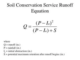
RUSLE FACTORSA = R K L S C P • R- Rainfall-runoff erosivity factor • K- Soil erodibility factor • L- Slope length factor • S- Slope steepness factor • C- Cover-management factor • P- Supporting practices factor
EROSIVITY - R • 22 years or longer rainfall data gathered by weather stations. • Single storm • Energy x 30 minute intensity • Annual-sum of daily values • Average annual-average of annual values • Monthly value=average annual x fraction that occurs on a given month
EROSIVITY - R Measure of erosivity of climate at a location Las Vegas, NV 8 Phoenix, AZ 22 Anchorage, AK 26 Denver, CO 40 Fairbanks, AK 48 Syracuse, NY 80 Juneau, AK 101 Minneapolis, MN 110 Chicago, IL 140 Richmond, VA 200 Dallas, TX 275 Birmingham, AL 350 Charleston, SC 400 New Orleans, LA 700
R-factor for Alaska • Retrieved from USDA RUSLE2 computer program data file at fargo.nserl.purdue.edu/rusle2_dataweb/RUSLE2_Index.htm. • AK is broken into climate zones per common resource areas (CRA) • Way to acquire an R-Factor: • Determine the climate zone ID in which the construction project is located from the map • Look up the R-factor from the table
SOIL ERODIBILITY - K • Measure of K-factor under standard unit plot condition • 72.6 ft long, 9% slope, tilled continuous fallow, up and down hill tillage • Represent the uniform soil at upper 6”of the subsoil (not topsoil) in a construction site • Major factors • Texture • Organic matter • Structure • Permeability
Obtain Soil Data • Perform gradation analysis • sand • silt • clay Options: • Information in Alaska Soil Survey Report published by NRCS. • Using soil-erodibility nomograph chart or equation. • Use regression equations in AH-703, Renard et al. (1997).
TOPOGRAPHY - LS • Slope length (L) and steepness (S) are major factors • Watershed topography affects erosion rate and sediment transport • Steep slopes typically result in rapid runoff • Long slopes acuminate more runoff
Hillslope Shape Convex Uniform Complex-Convex:concave Complex-Concave:convex Concave
Slope Length for Uniform Slope SOIL LOSS SEDIMENT YIELD SLOPE LENGTH RUSLE ESTIMATES TO HERE
Slope Length for Complex Slope Soil loss Deposition Sediment yield SLOPE LENGTH
LS Factor for Complex Slope • break it down into several fairly uniform segments where the gradient changes, preferably into equal lengths
Cover Management Factor C • The factor representing the site’s cover protection from rainfall impact. • The ratio of erosion between a specific ground cover and bare ground.
Cover-Management Effects Raindrops intercepted by canopy cover Raindrops not intercepted by canopy cover Canopy cover Intercepted rainfall falling from canopy cover Ground cover Ridges Buried residue Live roots Dead roots
Erosion Control Technology Council (ECTC)http://www.ectc.org/ • Industry authority in the development of standards, testing, and installation techniques • Rolled erosion control products (RECPs), • Hydraulic erosion control products (HECPs) • Sediment retention fiber rolls (SRFRs).
C-factor for Other Covers (Pitt, Clark and Lake, 2007; Fifield, 2004)
Mulch (Mechanical) and Rock Cover (Wischmeier and Smith, 1978)
Supporting Practices (P) Conservation practices are controllable, experience-driven and interactive measures. They can: enhance the factors of cover and soil texture mitigate the influence of rainfall and runoff modify flow path length and steepness
Supporting Practices • Strips/barriers • Buffer strips, • Filter fence, • Wattles • Straw bales, • Gravel bags • Diversions • Channel • Terrace • Impoundments • Sediment traps • Detention / retention pond
P-factor for Construction Sites (Fifield 2004 and Foster & Toy 1998)
Examples Steese Hwy R=31 Silty gravel (GM) K=0.17 80 % passing #10 35% passing #200 2.5:1 Slope/60 ft long LS=4.9 RKLS = 26 Tons/acre/yr
Examples • C=1, up and down slope trackwalking P= 0.9 • 70% perennial grass cover C=0.0275, P =1 • Mulching C=0.02, tracked P=0.9 CP x RKLS = 0.9x26 = 23 Tons/acre/yr CP x RKLS = 0.0275x26 = 0.7 Tons/acre/yr CP x RKLS = 0.02x0.9x26 = 0.5 Tons/acre/yr
Examples Valdez R=80 Silty gravel (GM) K=0.17 80 % passing #10 35% passing #200 2.5:1 Slope/60 ft long LS=4.9 RKLS = 67 Tons/acre/year
Examples • C=1, up and down slope trackwalking P= 0.9 • 70% perennial grass cover C=0.0275, P =1 • Mulching C=0.02, tracked P=0.9 CP x RKLS = 0.9x67 = 60 Tons/acre/yr CP x RKLS = 0.0275x67 = 1.8 Tons/acre/yr CP x RKLS = 0.02x0.9x67 = 1.2 Tons/acre/yr
SUMMARY • RUSLE is only for interrill and rill erosion, not for gully and channel erosion. • The result from RUSLE is estimated soil loss rate, cannot be interpreted as actual soil loss rate. • RUSLE AK use on unfrozen soil only