Download
1 / 11
110 likes | 122 Views
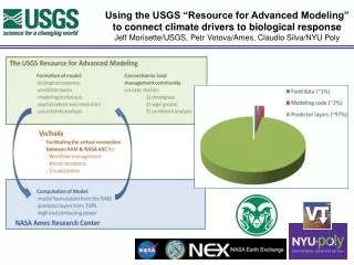
This resource focuses on the development of an operational capacity for advanced modeling in the USGS. It includes collaborations with Montana State University, NASA, and other organizations, and covers topics such as species habitat modeling, climate and land use adaptation, and data management challenges. The resource also highlights the use of tools like VisTrails SAHM and machine services for high-speed habitat modeling.

E N D
The USGS Resource for Advanced Modeling: Developing an operational capacity USGS (Morisette, PI) Montana State University (Hansen, PI) NASA Biodiversity Team meeting 1
USGS team Catherine Jarnevich Tracy Holcombe Colin Talbert Marian Talbert USGS-CSU Resource for Advanced Modeling Sunil Kumar Cam Aldridge Tom Stohlgren Dennis Ojima Tom Hilinski David Koop Claudio Silva Denis Ojima Andy Hansen Joe Barsugli David Blodgett Emily Fort Robin O’Malley Shawn Carter Doug Beard PetrVotava Rama Nemani Paul Evangelista 2
MSU team Using NASA Resources to Inform Climate and Land Use Adaptation Andy Hansen, Montana State University Scott Goetz, Woods Hole Research Center Bill Monahan & John Gross, NPS I&M Program Forrest Melton &Rama Nemani, CSU Monterey Bay / NASA Ames Tom Olliff, NPS and Great Northern LCC Dave Theobald, Colorado State University NASA Applied Sciences Program (NNH10ZDA001N - BIOCLIM) NPS I&M Program 3
VisTrails SAHM: visualization and workflow management forspecies habitat modeling Research product Initial paper to introduce the “Software for Assisted Habitat Modeling (SAHM). Specific modules in SAHM to incorporate MODIS products. Open access: Full details of the VisTrails:SAHM package and tutorial are given at https://my.usgs.gov/catalog/RAM/SAHM • Morisette et al., 2013. VisTrails SAHM: visualization and workflow management for species habitat modeling. Ecography 36: 129–135. doi: 10.1111/j.1600-0587.2012.07815.x
Data Management Challenges in Species Distribution Modeling Research product Describing the computational challenges in climate-data driven species distribution modeling and solutions using scientific workflow systems. • Where we are. • Where we’re going. • Talbert, C., M. Talbert, J. Morisette, D. Koop. 2013. Data Management Challenges in Species Distribution Modeling. IEEE Data Eng. Bull. 36(4)31-40, http://sites.computer.org/debull/A13dec/p31.pdf.
Operational Capacity Research product • VisTrails:SAHM training every six months (next training, fall 2014) • VisTrails:SAHM being used for • MSU and Greater Yellowstone Coordinating Committee work on White Bark Pine Habitat under climate change. • MSU modeling of 8 tree species in the Greater Yellowstone Area • Colorado Natural Heritage Program’s work with Colorado’s State Wildlife Action Plan • CSU/USGS work on migratory bird habitat models in the Plains and Prairie Pothole region • CSU work on Fruit Fly habitat • Others not directly working with our group • VisTrails will be used for operationalizing “Climate Primer” graphics and climate summaries. • Exploring machine services data access to USGS’s GeoDataPortal (climate) and NASA’s LP DAAC (satellite products)
Lessons learned • From Gross, Hansen, Goetz, Theobald, Melton, Piekielek, Nemani. 2012. Remote sensing for inventory and monitoring of the U.S. National Parks. Pages 29-56 in: Remote Sensing of Protected Areas • Allocate time to develop a genuine science-management partnership Communicate results in a management-relevant context
Lessons Learned • Communicate results in a management-relevant context
Lessons Learned • Conform or embellish existing frameworks and processes • Plan for persistence and change 9
Lessons Learned • Build on existing data analysis tools and software frameworks. VisTrails SAHM NASA TOPS
Conclusion • The USGS Resource for Advanced Modeling (RAM) has been greatly enhanced by support from the NASA Biodiversity Program. • The RAM has moved into an operational capacity, serving primarily the Department of Interior and a key component in the North Central Climate Science Center’s science delivery strategy. • Machine Services will provide a new and exciting tool for high-speed habitat modeling.