Download
1 / 1
10 likes | 165 Views
Significantly different from unscaled at:. Significantly different from unscaled at:. = 0.05 . = 0.05 . = 0.01 . = 0.01 . http://www.esrl.noaa.gov/gmd/grad/surfrad/bonpics/tower01c.jpg. Significantly different from unscaled at:. = 0.05 . = 0.01 . 1 km. 1 km.

E N D
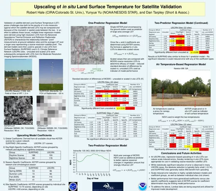
Significantly different from unscaled at: Significantly different from unscaled at: = 0.05 = 0.05 = 0.01 = 0.01 http://www.esrl.noaa.gov/gmd/grad/surfrad/bonpics/tower01c.jpg Significantly different from unscaled at: = 0.05 = 0.01 1 km 1 km Upscaling of in situ Land Surface Temperature for Satellite Validation Robert Hale (CIRA/Colorado St. Univ.), Yunyue Yu (NOAA/NESDIS STAR), and Dan Tarpley (Short & Assoc.) One-Predictor Regression Model Two-Predictor Regression Model (Continued) Validation of satellite-derived Land Surface Temperature (LST) poses challenges due both to the paucity of in situ measures against which the satellite-derived LSTs may be compared and because of the mismatch in spatial scale between the two. In an effort to address these issues, multiple linear regression models were derived using high-resolution LSTs from the Advanced Spaceborne Thermal Emission and Reflection Radiometer (ASTER) to characterize the relationship between “point” measurements at ground validation sites and the average LST over a larger area representing a coarse-resolution satellite pixel. The derived models were then used to upscale in situ LSTs from Surface Radiation (SURFRAD) and U.S. Climate Reference Network (USCRN) sites. Unscaled and scaled LSTs were subsequently compared with LSTs from the Moderate Resolution Imaging Spectroradiometer (MODIS). Single ASTER pixel encompassing the ground station used as predictor of large-area average LST USCRN Sites (22 sites) Once the and coefficients are determined using ASTER scenes, the formula is applied to in situ LSTs to determine scaled values Results at SURFRAD sites similar to those for 1-predictor model – No significant reduction in scale-induced error with any of the coefficient types http://www1.ncdc.noaa.gov/pub/data/uscrn/documentation/site/photos/stationsbystate_hires.pdf Scaled values then are compared with MODIS coarse-resolution LSTs to determine efficacy of model – reduced standard deviation of differences for scaled vs. unscaled LSTs used as indicator of model performance Air Temperature-Based Regression Model Newton 8W, GA 2 km x 2 km average LSTavg = 318.59 K Central pixel LSTpixel = 318.80 K LSTin situ = 312.76 K http://www1.ncdc.noaa.gov/pub/data/uscrn/documentation/site/photos/stationsbystate_hires.pdf Standard deviation of differences of MODIS – unscaled or scaled in situ LSTs (K) USCRN Sites (22 sites) USCRN (Newton 11SW, GA) Field of View of IRT: 1.3 m SURFRAD (Bondville, IL) FOV of Radiometer: ~30 m ASTER single-pixel or in situ LST used as indicator of soil surface temperature Air temperature used as a proxy for canopy temperature + SURFRAD Sites (7 sites) NDVI used to weight the two temperatures USCRN Sites (22 sites) ASTER LST (Stillwater 5WNW, OK; 7/23/2005) Resolution: 90 m MODIS LST (Stillwater 5WNW, OK; 7/23/2005) Resolution: 1000 m Upscaling Model Coefficients 1) Global Coefficients: Derived from all available cloud-free ASTER scenes for a given network SURFRAD: 246 scenes USCRN: 371 scenes 2) Day/Night-Specific Coefficients: ASTER scenes grouped by network and daytime or nighttime overpass No significant difference for any coefficient type Two-Predictor Regression Model Asheville 13S (NC) 2003-2010 Mean NDVI • Conclusions and Future Activities • At USCRN sites, regression-based upscaling of in situ LSTs can reduce scale-induced errors, thereby rendering in situ LSTs more appropriate for use in validating coarse-resolution satellite LSTs • While statistically significant reduction of error is observed in many USCRN cases, the absolute reduction is typically fairly small (~0.2 K), and SURFRAD sites generally realize little benefit from upscaling • Scale-induced error reduction is highly variable between models and coefficient groups, as well as between individual sites (not shown) • Better performance from more generalized coefficients versus site-specific coefficients suggests lack of ASTER scenes for coefficient determination may be limiting model performance • To address the above, Landsat data are being acquired and utilized for improved model development Multi-year average of MODIS NDVI used as additional predictor to better capture seasonal changes in vegetation amount that strongly influence LST 3) Season-Specific Coefficients: ASTER scenes grouped by network and climatological season 4) Site-Specific Coefficients: ASTER scenes grouped by individual site SURFRAD: 13-70 scenes, depending on site USCRN: 4-68 scenes, depending on site