Download
1 / 15
160 likes | 286 Views
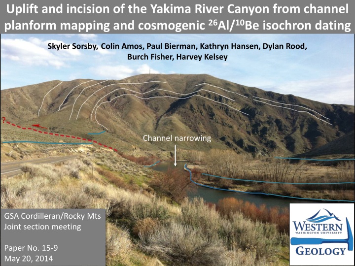
Skyler Sorsby , Colin Amos, Paul Bierman , Kathryn Hansen, Dylan Rood, Burch Fisher, Harvey Kelsey. Uplift and incision of the Yakima River Canyon from channel planform mapping and cosmogenic 26 Al/ 10 Be isochron dating. ?. Channel narrowing. GSA Cordilleran/Rocky Mts

E N D
Skyler Sorsby, Colin Amos, Paul Bierman, Kathryn Hansen, Dylan Rood, Burch Fisher, Harvey Kelsey Uplift and incision of the Yakima River Canyon from channel planform mapping and cosmogenic26Al/10Be isochron dating ? Channel narrowing GSA Cordilleran/Rocky Mts Joint section meeting Paper No. 15-9 May 20, 2014
Tectonic setting Study area ~1-2 mm/yr GPS shortening • NE-SW to E-W trending folds and thrust faults deforming miocene CRB • Tight anticlinal ridges and broad synclinal valleys cross-cut by the Yakima River. • GPS data predict ~1-2 mm/yr NE shortening (McCaffrey et al., 2013)
Outline Fluvial analysis components Methodology High resolution channel width data from planform mapping with Matlab toolkit Changeom (Fisher et al., 2013, Geomorphology) Terrace mapping and topographic analysis from lidar CRN terrace dating Key Questions • Are Yakima structures currently active? • Is Quaternary uplift differential or spatially uniform? • How do the Yakima Canyon terraces correlate? • What can CRN dating tell us about relative uplift rates?
Methods: Changeom Premise: Rivers may narrow across actively growing folds to gain incision power. Methodology: Channel planform digitized with high-resolution Google Earth imagery Changeom creates channel centerline through binary thinning Planform width is calculated from the centerline. from Fisher et al. (2013), Published in Geomorphology
Changeom results Channel width anomalies Distinct channel narrowing across Manastash, Umtanum, and Selah Butte structures Spatial correlation with mapped faults Substrate is uniform throughout the canyon (CRB) Lidar survey reveals a lack of prominent knickpoints
Terrace mapping Slope map from lidar Preliminary terrace map T5 T1 T2 T3 T4 T5 Old Young T5 T3 T3 T4 T5 T3 T5 T3 T5 Topographic profiling T4
Results: mapping Terraces Preliminary correlation based only on similar height above modern channel. Treads are often mantled with alluvium or altered anthropogenically Paleosurface remnants are patchy; downstream correlation is difficult from elevation data alone.
Results: mean elevation Selah Umtanum Manastash Higher terraces proximal to Manastash and Umtanum folds. Synclinal regions show greater clustering of lower terraces Implications for differential uplift across the canyon
Results: Tread profiling VE=30 VE=30 Profiles Profiling of terrace treads reveals: Increasing tilt as Umtanum fold axis is approached Negligible deflection of modern surface
Methods: 26Al/10Be CRN dating Isochron burial- Dating equation: (from Balco and Rovey 2008) Sampling procedure Quartz-rich river cobbles (likely source: Mt. Stuart Batholith) Sampled >2 meters depth to ensure proper shielding from cosmic rays Quartz cleaned and extracted at UVM Analysis performed at the SUERC AMS lab in East Kilbride, Scotland. T3
26Al/10Be isochron plots Toth Rd. MR Meander UR Big Pines Lab results: 26Al and 10Be concentrations are uniformly low (increases error to 1 std) YK-03 (Big Pines terrace): higher 26Al/10Be ratio—age is indistinguishable from modern. 3. YK-04 (Meander) and YK-05 (Toth Rd.): lower 26Al/10Be ratio; ages are 1.59 ± 0.25 and 1.08 ± 0.29 Ma respectively.
Results: CRN dates Similar ages at considerably different elevations! T2 T4 T5
Terraces under current investigation Adrian Bender (WWU MSc thesis) will date additional terraces (CRN burial) to assess differential incision rates in the Yakima River Canyon
Summary Channel narrowing across Manastash, Umtanum, and Selah Butte indicates the presence and distribution of modest Quaternary deformation. Evidence for Quaternary uplift of Umtanum seen in tilted terrace treads. Evidence for the Quaternary uplift of Manastash from CRN dating (same ages high on an anticline, low on a syncline) Further terrace dating will better constrain the timing, magnitude, and distribution of tectonic deformation in the Yakima Canyon.