Download

1 / 28
280 likes | 294 Views
This document provides an overview of the GPS Modernization Program, its goals, and the advancements in the GPS space segment and control. It discusses the addition of new signals, increased signal power, and improved anti-jam and security technologies. The document also highlights the development of a new civil code, the introduction of a third civil signal, and the future plans for GPS III. The modernization aims to enhance navigation capabilities for both military and civilian users while maintaining the integrity and security of the GPS system.

E N D
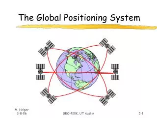
The Global Positioning SystemA Global Information Utility November 2001
The Interagency GPS Executive Board Defense Transportation State Commerce Agriculture Interior NASA Joint Chiefs of Staff Justice
Goals of GPS Modernization Program • Military • Protection of service for US/Allied forces • Add new signals and increased signal power to improve Navwar capability • Modify select platforms to detect and locate GPS jamming • Develop and field improved anti-jam and security technologies • Prevention of adversary exploitation • Spectrally separate new military signals from civil signals • Civil • Preservationof civil use while providing enhancements • Add new signals to improve accuracy and signal redundancy The Termination of Selective Availability was the first step in the GPS Modernization Process
C/A C code C/A C code M-code M-code M-code M-code P(Y) P(Y) P(Y) P(Y) GPS Space Segment Modernization • Block IIRs (12 SV’s) • Adds Civil Code to L2 • Adds new militaryM-Code • Increases signalpower Signals in Space L2 L1 Signals in Space • Adds civil L5 to all • Block IIFs L5 1176.45MHz L2 1227.6MHz L1 1575.42MHz GPS Modernization migrates to a system with spectrally separated military services while adding new civil services
GPS Space and Control New Civil Code on L2 • Advantages of a New Signal • Improved cross-correlation properties • Improved tracking capability -- 3dB higher power than Coarse Acquisition (C/A) on L2 • Signal Characteristics • Two codes - one with data (medium code); one without (long code) • Codes longer than C/A code to minimize cross correlation • Separated by time - Time Division Multiplexed (TDM) • Overcome some limitations of current C/A coded signals
Pre-Modernization Heritage Signals L1 C/A L1, L2 P(Y) Design Life 10 Years Post Modernization Modernized Signals Higher Power L1 C/A, L2 Second Civil L1, L2 P(Y) L1, L2 M-Code Design Life 10 Years GPS Space and ControlBlock IIR Modernization
Pre-Modernization Heritage Signals L1, L2 C/A L1, L2 P(Y) Design Life 15 Years 33 Satellite Production Run Post Modernization Modernized Signals Similar Power L1 C/A, L2Civil Signal L1, L2 P(Y) L1, L2 M-Code L5 New Civil Signal Design Life 12 Years 10 Year MMD 2 Rubidium Clocks and 1 Cesium 12 Satellite Production Run GPS Space and ControlBlock IIF Modernization
FIX FOM 1 N 42* 01” 46.12” W 091* 38’ 54.36” EL + 00862 ft 3 menu 1 ON 2 4 5 6 7 WPT 8 POS 9 NAV CLR MARK 0 OFF NUM LOCK ZEROIZE Rockwell GPS III Mission and System Description The GPS III System Maintain Space User Service Second Civil Signal Third Civil Signal • Review entire GPS Architecture to: • Achieve long term GPS performance goals • Reduce long term total ownership costs • Ensure GPS system properly assessesand is synergized with • Military and Civil Needs/Systems • Possible augmentation opportunities • Ensure best GPS system for the nation for the next 30 years
System Architecture/Requirements Development (SARD) Status GPS III • Contractor Studies – Nearing completion (Nov 01) • Alternative System Reviews completed • Baseline architectures identified • Contractors Recommended Performance based requirements • Significant parallelconclusions • Mid-Earth Orbit (MEO) is the best • Crosslinks are key to accuracy and reduced Age of Data (AOD) • No major UE impacts for Operational Requirements Document threshold • Government activity – “On Schedule” • Draft acquisition strategy in-review • Draft System Specification will be ready for early December RFP • Draft Test and Evaluation Master Plan in work
Schedule Going Forward GPS III • GPS III is entering the pre-acquisition phase. • Although civil requirements are currently contained within the Operational Requirements Document, the possibility for altering the ORD does exist, should there be validated civil requirements. • In approximately March of 2002, the contract award for the pre-acquisition phase will be released. • The downselect to one contractor will occur in 2004. • The schedule calls for launch of the first GPS III satellite in 2009, with Initial Operating Capability of the GPS III constellation in approximately 2016.
Modernization Summary • Modernization will increase capability for civil and military users • Second civil signal and new military signals beginning in 2003 • Third civil signal (L5) beginning in 2005 • GPS III addressing future dual-use requirements • Performance will dramatically improve as a result of modernization • U.S. continuing international outreach to be responsive to global user needs
Civil Involvement and Interface • DoD and civilian government agencies working together in various venues on modernization and GPS III • Policy and Planning • IGEB • Independent Assessment Team • Acquisition • Requirements • Interagency Forum on Requirements
Structure to support Plans and Policy already in place Draws from existing Pos/Nav policy structures within DoD and DOT Consolidates at the IGEB Civil Involvement in Plans and Policy Process IGEB IGEB Independent Assessment Team (IAT) SSG DOT Extended Pos/Nav DoD Pos/Nav Underlying Agency Staff Structures
Civil Involvement in Acquisition Process Milestone Decision Authority (MDA): USD(AT&L) DAB • IPT Structure • Provide strategic guidance, and program status/assessment • Identify and resolve issues at appropriate level • Seeks opportunities for acquisition reform • “Inter-disciplinary” participation • Civil representation at each IPT level • 3 -5 civil representatives • Full civil participation through Extended DOT Pos/Nav structure • IGEB • Fulfills role defined in PDD • Provides advisory role to DAB • Structure currently exists Overarching Integrated Product Team(OIPT) IGEB DOT Extended Pos/Nav EXCOM To gain broad civil consensus on GPS issues Integrating IPT (IIPT) DOT Extended Pos/Nav Working Group To work elements involving civil issues Working-level IPT (WIPT) Execution Level IPTs JPO Lead
Inter-Agency Requirements Council (IRC) Inter-Agency Requirements Council (IRC) • JROC Equivalent • JROC Equivalent Interagency Requirements Board (IRB) Interagency Requirements Board (IRB) • Flag Level • Flag Level O-6 and Flag Field Review O-6 and Flag Field Review Users Forum Users Forum Civil Involvement in Requirements Process Milestone Decision Authority (MDA): USD(AT&L) DAB IGEB • NPOESS Model • Provides forum to address requirements and solution trades which cross military/civil boundaries • Independent process from program development • Each agency’s requirements are accountable and traceable • Focused “user community” participation in field • Civil representation at each level • Not identical to IPT representation • Broad representation through Extended DOT Pos/Nav structure • IGEB • Fulfills role defined in PDD • Provides advisory role to DAB • Structure currently exists JROC - Approve Mil Requirement JRB - Coord & Adjudicate Mil Requirement JRP - Coord & Adjudicate Military Requirement DOT Extended Pos/Nav EXCOM To gain broad civil consensus on GPS issues Coordinate and Adjudicate Interagency Requirements DOT Extended Pos/Nav Working Group To work elements involving civil issues Operating Agencies’ Requirements Processes Services’ Requirements Process AFSPC lead --- parallel level to execution IPTs to participate in and provided guidance for development activities
FAA Satellite Navigation Programs WAAS and LAAS • Improved Aviation System Safety • Fewer Disruptions • Increased Capacity Why Satellite-Based Navigation? • Increased Fuel Savings • Low Operations Costs • Low Avionics Cost
Satellite Navigation Capabilities
Wide Area Augmentation System • WAAS Capabilities • Enroute Guidance • Non-Precision Approach • Category I Precision Approach at All Runway Ends in Service Volume • CONUS • Portions of Alaska • Hawaii • Portions of Caribbean • WAAS Approach Capabilities Implemented in Increments • Non-Precision • LNAV/VNAV (Lateral Navigation/Vertical Navigation) • Initial Operational Capability Level of Service - December 2003
Communication Satellite Auburn (ZSE) BrewsterGES Billings (BIL) Farmington (ZMP) GPS Satellite Nashua (ZBW) Oberlin (ZOB) SaltLakeCity (ZLC) Ronkonkoma (ZNY) Aurora (ZAU) Clarksburg GES Longmont (ZDV) Fremont (ZOA) Leesburg (ZDC) Olathe (ZKC) Santa Paula GES (2) Memphis (ZME) Albuquerque (ZAB) Palmdale (ZLA) Key FortWorth (ZFW) Hampton (ZTL) Phase 1 WRS Phase 1 WMS/WRS Phase 1 GES WMS= Wide-area Master Station WRS= Wide-area Reference Station GES= Ground Earth Station Anchorage (ZAN) Jacksonville (ZJX) Houston (ZHU) Juneau (JNU) Cold Bay (CDB) Miami (ZMA) San Juan (ZSU) Honolulu (HNL) WAAS Fielding Status System Available for Non-Aviation Safety Uses Since Aug 2000
WAAS Integrity Issue • WAAS IOC Slipped From Sept 00 to Dec 03 • System Integrity Problem Identified in Jan 00 • Analysis of System Architecture Could Not Prove That Stringent System Integrity Requirement Was Met • Integrity Is the System’s Ability to Provide Timely Warnings to Users When It Should Not Be Used for Navigation • FAA Formed Panel of Experts To Develop Solution • Resulted in Improvements for 8 System Monitors • Improvements On Track • Three Monitor Improvements Now On WAAS Signal • Panel Continues • LNAV/VNAV Implementation Oversight
Local Area Augmentation System • Goal • Provide Extremely High Accuracy, Availability, and Integrity Required for Category II and Category III Precision Approaches • Category I Approach in Areas Not Served by WAAS or Requiring Higher Availability Than Provided by WAAS • Surface Navigation • LAAS Full Deployment • 46 Category I Systems • 114 Category II/III System • Initial Operational Capability Expected in 2003
LAAS Development • Phased: Partnership / Federal Phased Acquisition • Government Industry Partnership (GIP) Cost Sharing Agreements in Place • Develop LAAS to FAA CAT I Specification Requirements • GIP Agreements Period of Performance Through December 15, 2001 • LAAS Category I Contract Award Planned Summer 02 • Leverages GIP Development but Incorporates Added Requirements • Initial CAT I LAAS Operational by 4th Quarter of 2003 • LAAS Category II/III Acquisition Beginning in 2003 • Operational in 2006
Principles for Cooperation • No direct user fees for civil and public safety services • Ensure open market driven competition for user equipment and applications • Open signal structure for all civil services to promote equal access for applications development and value added services • Protection of the current radionavigation spectrum from disruption and interference • Use of GPS time, geodesy, and signal structure standards • Seamless, globalinteroperability of future systems with GPS • Recognition of national and international security issues and protecting against misuse