Download
1 / 20

E N D
1. 11_CO.jpg CHAPTER OPENING FIGURE (pp. 278-279)
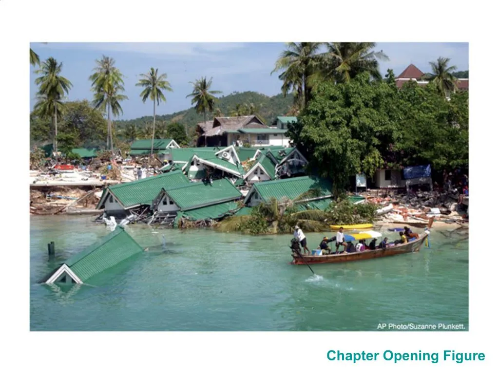
A boat approaches the wreckage of a hotel at Ton Sai Bay on Phi Phi Island, Thailand, two days after the hotel was destroyed by a tsunami. Although this damage is significant, this same tsunami rose to much greater heights and caused far more severe damage on the Island of Sumatra, on parts of mainland Thailand, and even on the Island of Sri Lanka, which is far from the area where the tsunami was spawned (in the ocean northwest of Sumatra). All told, more than 220,000 people died in eleven different countries in southern Asia and Africa.
CREDIT: AP Photo/Suzanne Plunkett.CHAPTER OPENING FIGURE (pp. 278-279)
A boat approaches the wreckage of a hotel at Ton Sai Bay on Phi Phi Island, Thailand, two days after the hotel was destroyed by a tsunami. Although this damage is significant, this same tsunami rose to much greater heights and caused far more severe damage on the Island of Sumatra, on parts of mainland Thailand, and even on the Island of Sri Lanka, which is far from the area where the tsunami was spawned (in the ocean northwest of Sumatra). All told, more than 220,000 people died in eleven different countries in southern Asia and Africa.
CREDIT: AP Photo/Suzanne Plunkett.
2. Tsunami Evidence
3. Evidence for Previous Major Tsunamis
4. Tsunami Tsunami are long-wavelength, shallow water waves caused by rapid displacements of ocean water
From Japaneese, for Tsu (harbour) and name (wave)
Often called tidal waves but have NO relation to tides
5. Generating Tsunamis Earthquakes below subduction zones can have large vertical movement (reverse fault) that generates tsunamis
E.g. Magnitude 9.0 earthquake occurred at 7:58:53 AM local time on Sunday, December 26, 2004
Earthquakes on a strike-slip fault have mostly horizontal movement and tend not to generate tsunamis
E.g. the magnitude 8.1 Macquerie Island earthquake near New Zealand at 1:59 AM local time on 23 December 2004
Animations of fault motion http://www.iris.washington.edu/gifs/animations/faults.htm
6. Tsunami Magnitude The size of a tsunami depends partly on the size of an earthquake
usually given as a Richter Scale magnitude
Magnitude is a measure of the strength of an earthquake or strain energy released by it,
An increase of one unit of magnitude (for example, from 8.1 to 9.1) represents
a 10-fold increase in wave amplitude on a seismogram or
approximately a 30-fold increase in the energy released.
7. Tsunamis in the Open Ocean If an earthquake generates a tsunami, it propagates away from the earthquake zone as a shallow-water ocean wave
Such waves have a wavelength that is greater than the depth of the water
Wavelengths often greater 200 km
Thus all properties of shallow water water waves, including refraction, apply to them
Speed is there vgH
In the Pacific, a typical depth of 4,600 m would give a speed of 212 m/s (~760 km/hr)
Amplitude small in the open ocean.
The rate at which a wave loses its energy is inversely related to its wavelength. A tsunami not only propagates with a high speed, it also can travel a great, transoceanic distance with only limited energy loss.
9. Tsunamis and the Coast When the tsunami approaches the coastline:
its speed decreases (as the water depth decreases)
its amplitude increases as energy is converted from kinetic into potential
Waves can easily reach 10+ m in amplitude
10. Tsunamis and the Coast The first wave to reach the coast is often not the highest
11. Indian Ocean Tsunami in the Atlantic
12. Tsunami For a tsunami, if the crest arrives first (associated with upward crustal motion during original seismic event), wave will arrive first
If the original event had downward crustal motion, the trough will proceed the crest
This causes the water along the shore to receed by up to 3-4 m over 2-3 minutes
14. Tsunami Frequency
15. Canadian Tsunamis
16. Canadian Tsunamis British Columbia Outer Coast-1700
Burin Peninsula (Newfoundland) -1929
an offshore earthquake (magnitude 7.2) on the floor of the Atlantic Ocean caused a massive submarine slump (landslide), which generated a large ocean wave (tsunami);
the tsunami drowned 27 people when it struck the Burin Peninsula
17. Burin Tsunami
18. Canadian Tsunamis British Columbia-1960
caused a 1.2 metre wave at the Tofino tide gauge;
run-up was higher in many areas;
damage to log booms occurred along the west coast of Vancouver Island and the Queen Charlotte Islands
Port Alberni-1964
An earthquake in Alaska of magnitude 8.5 generated a 3.6 metre tsunami
caused $4.7 million in damages along the west coast of North America (including British Columbia, the Queen Charlotte Islands and Vancouver Island);
no Canadian fatalities (warning system worked)
19. Tsunami Warning Systems Warning Network
1) Earthquake reported by global seismic network
2) Offshore buoys/satellites measure wave heights
3) Models predict size of waves and timing when reach coast
4) Local Emergency Response units contacted
B.C. Tsunami Alert Plan
http://www.pep.bc.ca/hazard_preparedness/Tsunami_Brochure/Prepare_for_Tsunami.html
20. Canadian Tsunami Prediction Model: MOST3 (Method of Splitting Tsunamis, version 3)
computes generation, propagation and runup of tsunami waves and currents
Run by Department of Fisheries and Oceans (DFO) � Syndey, B.C.
http://www-sci.pac.dfo-mpo.gc.ca/osap/projects/tsunami/tsunamimodel_e.htm