Download
1 / 12
120 likes | 135 Views
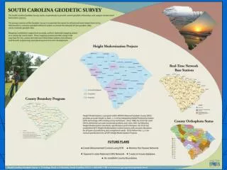
DRAFT - DO NOT DISTRIBUTE. Overarching Objectives of NOAA’s Proposed National Height Modernization Program. DRAFT - DO NOT DISTRIBUTE. THE MISSION. NOAA’s National Geodetic Survey is responsible for defining, Maintaining, and providing access to the National Spatial

E N D
DRAFT - DO NOT DISTRIBUTE Overarching Objectives of NOAA’s Proposed National Height Modernization Program
DRAFT - DO NOT DISTRIBUTE THE MISSION NOAA’s National Geodetic Survey is responsible for defining, Maintaining, and providing access to the National Spatial Reference System (NSRS). • Height Modernization enhances the Vertical aspect of the NSRS • Through the establishment of accurate, reliable heights using GPS technology in conjunction with tradition leveling, gravity work, and remote sensing information. • Not Just heights on benchmarks • Not just positioning with GPS
DRAFT - DO NOT DISTRIBUTE Percentage of Resources by Capability
DRAFT - DO NOT DISTRIBUTE New Initiative at NOAA: Regional Collaborations Teams • Integrate National and Regional Programs and Activities • Improve NOAA’s productivity and value to customers • Seek to identify and apply NOAA’s full range of capabilities • Design the best Geographically- specific solution for Customers • No Changes to NOAA’s Organizational structure
DRAFT - DO NOT DISTRIBUTE WHAT DOES REGIONAL COLLABORATION MEAN TO HEIGHT MODERNIZATION PARTNERS? • States Address Height Modernization on a National Level • Elevation issues are regional Mid Atlantic - Coastal riverine flooding West Coast - Tectonic movement Gulf Coast - Subsidence Great Lakes - Uplift • Efficient use of Funding and Workforce by NOAA Partners • Benefits Of Region Coordination • Optimize Resources, Technology and Benefits • Address Common Elevation Problem • Document Height Requirements
Height Modernization Activities in Coordination with Other NOAA’s Programs. • National Hurricane Center • Inundation models • National Weather Service • Tsunamis • GPS Ionosphere • Weather Models • Marine Fisheries • SWaPS, Benthic Mapping • Ocean and Atmospheric Research • Climate Change and Sea Level Rise • Atmospheric Models • National Ocean Service • NWLON (CO-OPS) • Digital coasts (CSC) • Coastal mapping/shoreline (NGS/Coast survey) • Coral Reef Conservation Program (OCRM/NCCOS) • Coastal Zone Managers (OCRM)
Program Priority(Urgent Need) • Continue to make progress and build on existing programs • Link Height Modernization to other major programs. • Gulf of Mexico – continued intense effort the due to activities which have resulted in loss of life and costly replacement of infrastructure • Areas of extensive surface motion activities • Area of severe weather events • Hurricanes, tornados, riverine and coastal flooding • NOAA Priority including cooperation FEMA & USACOE • Mid Atlantic, Pacific, Northwest and Great Lakes • Decreasing NGS’s infrastructure, enhancing models and tools, and building outside local capacity
Years to follow • Spatial Reference Centers and National Zone Leaders will assist other states in completing goals: • Assist in developing capacity • Work directly to help maintain the program • Provide initial plan to facilitate becoming independent • Enable NOAA to move primary support to other zones • The states within the zones will implement and complete a program plan
Where Do We Want To Be In Ten Years? • All new technologies will be utilizing the modernized height system • Regardless of your location or the time of day one the goal will be to obtain 2-cm orthometric heights in 10 minutes of observation time.
How do we get there? • Develop a shared height modernization vision for the nation. • Develop a high level collaborative strategic approach with partners where roles are established and priorities are set. • Innovative organizational structures • Develop broad based needs assessment • Inform and solicit the cooperation of constituents • Develop outreach and information for our users which will demonstrate the benefits