Download
1 / 16
160 likes | 321 Views
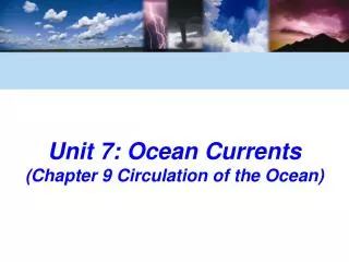
Unit 4.3: The Ocean. Origin of the oceans (a review):. Early volcanic activity Water vapor is released during volcanic explosions, condenses to liquid - “ outgassing ” Salts : mostly NaCl , but also Mg, Ca, K Mostly from chemical weathering of continental rocks, carried to ocean by rivers

E N D
Origin of the oceans (a review): • Early volcanic activity • Water vapor is released during volcanic explosions, condenses to liquid - “outgassing” • Salts: mostly NaCl, but also Mg, Ca, K • Mostly from chemical weathering of continental rocks, carried to ocean by rivers • Outgassing contributes salts also
Tides • Caused by gravitational pull of moon • High tide: areas on Earth in line with moon - pulls oceans closer to moon • Low tide: areas on Earth at right angles to moon’s pull • b/c Earth rotates, 2 high tides and 2 low tides every day • Highlow in 6 hours, 12.5 minutes • Lowhigh in 6 hours, 12.5 minutes • Sun exerts pull also, but not as strong. Why not? • b/c farther away
Cumulative effects: • When moon and Sun are lined up, gravitational pull is strongest, so highest high tides of the month • “spring” tides • @ full and new moons • When moon/Earth/Sun form a right angle, gravitational pull is “weakest”, so lowest low tides of the month • “neap” tides • @ ¼ and ¾ moons
III. Layers of the Ocean: • 3 ways to classify layers: • temperature, salinity, life • Layers of Temperature: • Shallow, mixed zone • Top layer; warmest b/c Sun’s radiation heats it • Transition zone • Defined by rapid change in temperature called a thermocline: • “-cline” – to lean, bend • Deep zone • Constant temperature: ≤4°C
Layers of Salinity: • Average salt concentration in parts per thousand (ppt) is ~3.5% by weight or 35‰ • Surface layer has highest salinity, but varies by region: • If high evaporation, then less water, so higher salinity (Mediterranean) • If high precipitation, then more freshwater, lower salinity • Polar regions: formation of sea ice “squeezes out” salt, so higher salinity • Transition zone: rapid change in salinity • halocline: “halo-” = salt • Deep zone: salinity is fairly constant
Layers of Life: Sub-classified in 3 ways: • Availability of sunlight: • Photic zone: light can penetrate, photosynthesis can occur • Varies depending on water clarity • Aphotic zone: no sunlight • Distance from shore: • Intertidal: exposed at low tide, but covered at high tide • Neritic zone: most diversity • Oceanic: open ocean, like a desert b/c less “food”
Depth: • Pelagic zone: open ocean, animals swim or float • Benthic zone: bottom-dwellers • Abyssal: deep-sea bottom; high pressures, low temps • Hydrothermal sea vents: underwater hot springs • Form at rift zones near plate boundaries • Warm enough to support “chemosynthetic” life • Rich in minerals/nutrients
Ocean Currents • Surface currents: • Speed due to pull of the wind • Direction due to Coriolis effect • Deflection of air/water due to Earth’s rotation • Northern hemisphere: currents run clockwise (to the right) • Southern hemisphere: currents run counterclockwise (to the left)
Gyres - huge circular-moving current systems that dominate the ocean’s surface • Five main ocean gyres: • North Pacific Gyre, South Pacific Gyre, North Atlantic Gyre, South Atlantic Gyre, and the Indian Ocean Gyre • Trash/plastics “collect” within these gyres, can be ingested by marine organisms
Upwelling: vertical movement of water due to wind Deep, cold water rises to replace warmer water on West coast of continents/East coast of oceans – why? Winds blow toward equator, paralleling the coastline. Coriolis effect pushes warm surface layer away from coast, replaced by colder water that upwells from lower ocean. California coasts ~15°C, but N. Carolina coasts ~21°C
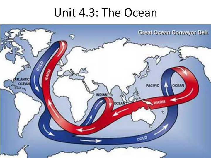
Deep Ocean Circulation: • Dependent primarily on differences in density • “thermo-”: Temperature: colder water = more dense • “haline-”: Salinity: more salt = more dense • ... called “thermohaline” current • Takes 500-2000 years for water to circulate through the thermohaline current
Surface water loses heat/water to atmosphere, becomes colder/saltier, then sinks b/c more dense • Polar water is coldest, saltiest, so it sinks and is carried toward equator • @ equator, upwelling moves surface water away, replaces it with cold water from ocean bottom • Once at the surface, water heats up, and is carried toward poles • Like a global conveyor belt…