Download
1 / 29
290 likes | 470 Views
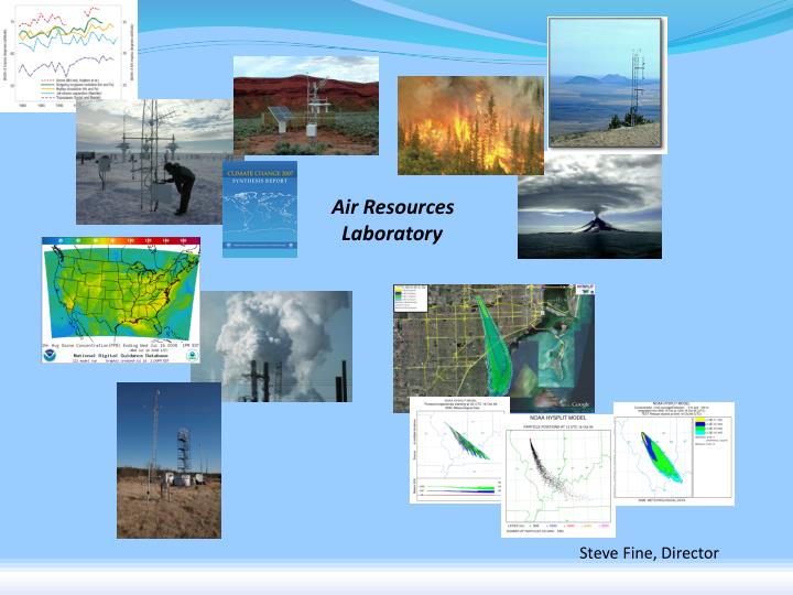
Air Resources Laboratory. Steve Fine, Director. Outline. Background R&D Areas Atmospheric Transport and Dispersion Air Quality Climate Boundary Layer. Genesis of Lab. 1948: Special Projects Section of U.S. Weather Bureau Provide meteorological expertise to other Federal agencies

E N D
Air Resources Laboratory Steve Fine, Director
Outline • Background • R&D Areas • Atmospheric Transport and Dispersion • Air Quality • Climate • Boundary Layer Air Resources Laboratory
Genesis of Lab • 1948: Special Projects Section of U.S. Weather Bureau • Provide meteorological expertise to other Federal agencies • Atmospheric factors were very important to emerging issues of the 1940s and 1950s • Cold War & Nuclear Arms Race • Weapons Testing • Safety • Detection • Nuclear energy: safety • Environmental protection • Climate work began in 1960s
ARL Today • ~85 employees & contractors • R&D Areas • Atmospheric transport and dispersion • Air quality • Climate • Planetary boundary layer (PBL) • Area of emphasis for other topics • Additional activities • Strong commitment to applications • Partner with a wide variety of other research institutions
Lab Organization • Four primary locations • Headquarters • Atmos. transport & dispersion, air quality, climate • Atmospheric Turbulence & Diffusion Division • Atmos. transport & dispersion, air quality, climate, PBL • Field Research Division • Atmos. transport & dispersion, PBL • Special Operations & Research Division • Atmos. transport & dispersion, PBL • Staff at two additional locations • NOAA Chesapeake Bay Office • Canaan Valley Institute 3 5 1 6 4 2
Atmospheric Transport & Dispersion • Motivations • Airborne hazardous materials can significantly impact communities (radiological, chemical, biological) • Volcanic plumes are a hazard to aviation • Goal • Improve understanding and prediction of atmospheric transport, dispersion, and turbulence • Benefits • Improved protection of emergency management personnel and the public • Reduced impact to the economy
HYbrid Single-Particle Lagrangian Integrated Trajectory (HYSPLIT) Model • Description • Computes trajectories, dispersion, and deposition • Uses variety of meteorological fields • Highly configurable, fast • Key Accomplishments • Widespread use • Easily applied to a broad range of applications • Transport scales 5 to 5000 km • Radiological, fire smoke, dust, volcanic ash • Prototype web-based system for operational applications • Future Directions • Better estimates of uncertainties • Better support for fine-scale emergency response operations http://www.arl.noaa.gov/HYSPLIT_info.php
Selected HYSPLIT Applications • Radiological Incidents / Intl. Atomic Energy Agency • Volcanic Ash • Local Emergencies • Wildfire Smoke • Ballooning • Dust • Crop Pathogens • Air Quality Krupa et al., 2006
Air Quality R&D • Motivations • Tens of thousands of premature deaths annually • Health effects and emissions control costs > $100B/year • Significant ecosystem impacts • Goals • Provide tools and information to support policy and regulatory assessments • Improve air quality prediction system • Benefits • Well informed air quality policies and regulations • Protection of public health • More effective investments in air quality management
Air Quality Forecast Guidance for Ozone and Fine Particulate Matter • Description • Real-time forecast system for NWS • Key Accomplishments • Ozone: Continental U.S. operational • PM version being evaluated • Results used by forecasters and the public • Future Directions • Dust and other PM http://www.weather.gov/aq
Climate R&D • Motivations • Significant challenges remain in understanding climate variability and trends • Air-land processes that affect climate are not fully characterized • Significant uncertainties in the regional impacts of climate change • Goals • Improve observation and understanding of climate variability and change • Assess regional climate impacts • Benefits • Reduced impacts of climate change and/or mitigation costs
Climate Variability and Change Analysis • Goals: • Analyze diurnal to multi-decadal climate variations • Understand long-term changes • Selected topics: • Data homogeneity adjustments • Uncertainties & trend detection • Solar, volcanic, El Niño, and quasi-biennial signals in T & O3 • Trend detection: T, water vapor, tropopause height, tropical belt • Analysis of radiosonde data • Climatology of boundary layer • Potential future activities: T profiles, clouds, and circulation patterns http://www.arl.noaa.gov/CVCAnalysis.php
Model-data comparisons Trends in tropical temperature Response to volcanic eruptions Data Mean of 6 models models data Lanzante and Free 2008 Free and Lanzante 2008
Boundary Layer Climatology • Description • Characterize climatology of the boundary layer • Use radiosondes and GPS-based observations • Expected Benefits • Understand variability and change of the boundary layer • Evaluate climate models Preliminary results Zhang, et al., in preparation for J. of Climate
Climate Extension of WRF • Description • Contribute to development of • regional climate modeling • system • Advanced/flexible physics options • Close partnership with academia • Key Accomplishments • Applications to environmental, • agricultural, and water resources • issues • Future Directions • Release as community model • Multiphysics ensembles Cloud Aerosol Radiation
Surface Energy Budget Network Air Resources Lab Earth Systems Research Lab
Climate Reference Networks • Goals • Observe national/regional climate signals • Highly accurate/reliable observations • Roles (vary by network) • Lead network establishment • Analyze performance / design • Design instrument suite • Install/maintain systems
USCRN Benchmark Stations at 29 locations in Alaska to better • document, monitor, and assess climate variability and change Barrow Red Dog Mine Fairbanks Summit Tetlin NWR Kenai NWR Port Alsworth Yakutat Sitka St. Paul Is. Sand Point
U.S. Regional Climate Network Southwest Pilot Installations 48 USHCN-M Sites Installed 14 CRN 12 Installations in Queue 6 Installs in progress 70 SLAs in Progress 1 Paired CRN & USHCN-M
GCOS Reference Upper-Air Network (GRUAN) • Goal: Reference-quality in situ profile observations for long-term climate monitoring/ research and to support evaluation of satellites • ARL Roles • Providing scientific guidance • Development of network requirements • Future directions • Analysis of GRUAN observations
Boundary Layer • Motivations • Boundary layer is a critical factor in the interaction between the atmosphere and the land surface and in determining local conditions • Goals • Develop observing technologies and approaches • Improve process understanding • Improve models • Benefits • Improved analyses and predictions for weather, climate, air quality, dispersion • Address societal needs for aviation, fire weather, homeland security • Activities • Mesonets • Low-level wind predictions • Soil moisture instrument comparison • Spatial variability of skin temperature
Spatial Variability of Skin(Surface) Temperature • Description • Improve interpretation of observations and predictions through better understanding of spatial variability of skin temperature • Key Accomplishments • Initial comparison of measurements from surface, aircraft, and satellite • Future Directions • Measurements in more regions • Better interpretation of observations and estimates of uncertainties