Download
1 / 31
310 likes | 326 Views
Access value-added surface albedo datasets derived from Terra MODIS for ground, airborne, and remote sensing applications. Explore temporal and spatial variability by ecosystem class and gain insights for global change projects. Files stored in compressed HDF format for easy access.

E N D
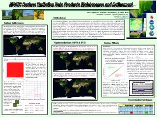
Spatially Complete Global Spectral Surface Albedos: Value-Added Datasets Derived From Terra MODIS Land Products Eric G. Moody1,2, Michael D. King1, Steven Platnick1, Alan H. Strahler 3, Crystal Schaaf 3 , Feng Gao 3 1NASA Goddard Space Flight Center 2L3-Communications GSI 3Boston University
Spectral, Spatial, Temporal Dependence • Inherent Ecosystem Class Dependency • Ancillary input for: • Ground, Airborne, and Remote Sensing Radiative Transfer Applications. • Land Surface and Climate Modeling. • Global Change Research Projects. modis-atmos.gsfc.nasa.gov
MOD43B3 - MODIS Land Surface Albedo • 0.47, 0.555, 0.67, 0.858, 1.24, 1.64, 2.1 µm • 0.3-5.0, 0.7-5.0, 0.3-0.7 µm. • 16-day periodicity (001, 017, …, 353). • Sinusoidal Projection Tiled Storage. modis-atmos.gsfc.nasa.gov
MOD43B30.858µmFilled Map modis-atmos.gsfc.nasa.gov
Spectral Variability by Ecosystem Class. modis-atmos.gsfc.nasa.gov
Temporal Variability. Cropland Ecosystem Urban Ecosystem modis-atmos.gsfc.nasa.gov
IGBP Ecosystem Classification Map • MOD12Q1. Friedl, Hodges, et al. modis-atmos.gsfc.nasa.gov
Phenological Concept modis-atmos.gsfc.nasa.gov Image provided by Xiaoyang Zhang, Boston University
Deciduous Broadleaf Forest, Vermont US. Phenological Curves Phenological Curves with Offset Applied modis-atmos.gsfc.nasa.gov
Processing Path. modis-atmos.gsfc.nasa.gov
General Methodology • Temporally Interpolate using Pixel-level or Regional Ecosystem Statistical Data. • If statistical data: • Compute behavioral curve and apply offset. • 1/2º, 1-5º, 10ºx10º, and 10ºx20º, 10ºx30º resolution. • Least Squares Polynomial Fit. • 1st - 3rd degree, with standard deviation weighting. • Select statistical size based on: • Temporal coverage. • Representation of pixel data. • Bias towards smaller box sizes. • Fill in only missing days. modis-atmos.gsfc.nasa.gov
Cropland, Midwestern US. Phenological Curves Phenological Curves with Offset Applied modis-atmos.gsfc.nasa.gov
MOD43B3 • 0.858µm • Filled Map modis-atmos.gsfc.nasa.gov
MOD43B3 • 0.858µm • Filled Map modis-atmos.gsfc.nasa.gov
Seasonal Snow Methodology • Cloud and snow cover obscure full decay state. • Over Hemisphere Average of High Latitudes: • Unique ecosystem and wavelength extrema percent change. • Compute % change from pixels with adequate representation. • For each Pixel/Statistical Curve: • Summer extrema known. • Compute winter extrema from • Percent change. • Summer extrema. • Pin winter endpoints with computed value. modis-atmos.gsfc.nasa.gov
Mixed Forest, Northern Russia. Seasonally Snow Impacted. modis-atmos.gsfc.nasa.gov
MOD43B3 • 0.858µm • Filled Map modis-atmos.gsfc.nasa.gov
Special Case: Missing Season. modis-atmos.gsfc.nasa.gov
Special Case: Limited Yearly Data. modis-atmos.gsfc.nasa.gov
0.858µm • Filled Map • MOD43B3 modis-atmos.gsfc.nasa.gov
Persistent Cloud Methodology • Clouds obscure trends over large regions. • Usually full growth stage is obscured. • Even 10x30 may not observe complete temporal trend. • Compute 1 statistical curve per ecosystem class. • 5-15° Latitude belts. • Centered around pixel’s latitude. • Yearly phenological behavior curves • Instead of 2 half year curves. • Impose shape of curve onto existing pixel data. modis-atmos.gsfc.nasa.gov
Pixel with No Temporal Points • Substitute ecosystem statistics. • Smallest statistical box size that has some temporal data. • Process pixel through one of the methodologies. modis-atmos.gsfc.nasa.gov
0.858µm • Filled Map • MOD43B3 modis-atmos.gsfc.nasa.gov
Snow Albedo By Forest Ecosystem Classes. modis-atmos.gsfc.nasa.gov
Snow Albedo By Vegetated Classes. modis-atmos.gsfc.nasa.gov
Available Products • Spatially Complete Albedo Maps • Maps and QA Stored in 1-minute Rectangular Coordinates. • First Seven MODIS Wavelengths and 3 Broadband. • White- and Black-sky albedo values. • Statistics of Filled Albedo Maps • 1/2, 1, 2, 3, 4, 5, 10 Degree Box Sizes. • Statistics Computed in Boxes and by Ecosystem Class in Boxes. • Statistics of Snow Albedos. • Hemispheric averages of MOD43B3 validated data. • Separated by Ecosystem class and NISE wet/dry classification. • IGBP Ecosystem Classification Map • Maps and QA Stored in 1-minute Rectangular Coordinates. modis-atmos.gsfc.nasa.gov
Format and File Sizes. • All data stored in HDF format with/without internal GZIP compression. • Spatially Complete Albedo Maps • 1 file contains 1 band and either white- or black-sky albedo per 16-day period. • QA and data stored in separate files. • 1 data file ~ 60 MB gzipped, 445 MB non-zipped. • 1 QA file ~ 10-25 MB gzipped, 225-445 MB non-zipped. • Statistics of Filled Albedo Maps • Only data, no QA. • Variable file size depending on resolution. • Statistics of Snow Albedo • 1 file, ~16 KB. • IGBP Ecosystem Classification Map • 1 static map ~ 90 MB gzipped, 1.1 GB non-zipped. modis-atmos.gsfc.nasa.gov
http://modis-atmos.gsfc.nasa.gov modis-atmos.gsfc.nasa.gov
http://modis-atmos.gsfc.nasa.gov modis-atmos.gsfc.nasa.gov
NDVIComputed from Filled Albedo Maps. modis-atmos.gsfc.nasa.gov


![H. Liu [1]* , D. Bedau [1] , D. Backes [1] ,](https://cdn1.slideserve.com/2479170/slide1-dt.jpg)