Download
1 / 43
650 likes | 1.46k Views
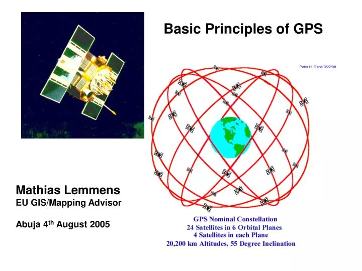
Basic Principles of GPS. Mathias Lemmens EU GIS/Mapping Advisor Abuja 4 th August 2005. Contents. Introduction GPS as a surveying tool Methods of Observation Accuracy Aspects Sources of GPS Error. Global Positioning System (GPS).

E N D
Basic Principles of GPS Mathias Lemmens EU GIS/Mapping Advisor Abuja 4th August 2005
Contents • Introduction • GPS as a surveying tool • Methods of Observation • Accuracy Aspects • Sources of GPS Error
Global Positioning System (GPS) • Satellite-based navigation and positioning system, original developed for military purposes by the US Department of Defense in 1972 • Applied in many fields as diverse as geodesy, GIS, precise cadastral mapping, cartography, vehicle guidance and atmospheric research • The phenomenal progress in receiver hardware is continuously widening the scope of applications of this unique technique.
Advantages of GPS as Surveying Tool • Transmission of signals that can be "seen" over a far larger area than ground-based systems (no line of sight necessary) • Weather (transmission signals through cloud and rain) and day-time independent • They recognise no national boundaries, and hence can be used globally wherever they are visible, on the ground, in the air and at sea.
Three segments • : • SPACE SEGMENT • comprising the satellites themselves, transmitting the signals necessary for the system to operate. • CONTROL SEGMENT • ground facilities carrying out the task of satellite tracking, orbit computations, telemetry and supervision necessary for the daily management of the Space Segment. • USER SEGMENT • entire spectrum of applications equipment and computational techniques that provide the users with the position results.
Methods of Observation • Infrastructural Support • Stand Alone • Local Differential GPS • Long Distance Differential GPS • Wide Area Differential GPS
Stand Alone GPS Positioning by using one Receiver • From the distances measured to at least 4 satellites X, Y, Z and the time bias (clock error) are computed • No additional infrastructure required • Accuracy is limited
Local Differential GPS • Two GPS receivers, one at a known point • Transmission of correction messages to the other receiver(s) • Influence of many errors can be reduced • Much higher accuracy possible than with stand alone
Long Distance Differential GPS • Relative positioning with the fixed receiver transmitting correction messages to the other receiver(s) • The further the user is away from the base station the less appropriate the corrections
Wide Area Differential GPS • An integrated network of base stations over a (part) of a continent is uses, e.g. • WAAS in the US (Wide Area Augmented System) • EGNOS in Europe (European Geostationary Navigation Overlay Service
Accuracy Aspects • Noise • Bias (systematic error) • Blunder
Normal probability density function (pdf). The width of the function represents the uncertainty. When a coordinate is normally distributed, the 1-s interval to both sides about the mean (m) contains about 68% of the samples, and 95% of the samples (in yellow) will lie within the interval [-1.96s, 1.96s] about the mean .
Accuracy and precision are often used interchangeably; precision refers to only the spread, no matter the bias, whereas accuracy both spread and bias includes Right, the precision of the observable in dark-blue and the one in light-blue is the same, but the latter has been biased due to for instance a remaining systematic effect. In the absence of biases (Left) precision and accuracy can be used synonymously.
Position Dilution of Precision (PDoP) • Dimensionless Number between 1 (best) and infinite (worst) • Indicates how good is the geometry of the satellite configuration
Quality of GPS measurements controllable by user • Number of satellites (at least 4) • Configuration of satellites (PDOP) • Short travel time through atmosphere (avoid use of low satellites) • Number of independent observations per station • Time of Measurement
Thank you very much for your attention Questions?