Download
1 / 1
10 likes | 119 Views
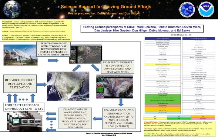
GOES-R Product Set - 68. GOES-R 34 Baseline Products. GOES-R 34 Additional Products (Option 2). Aerosol Particle Size. Aerosol Detection (incl Smoke & Dust). Suspended Matter / Optical Depth. Aircraft Icing Threat. Volcanic Ash: Detection & Height. Cloud Ice Water Path.

E N D
GOES-R Product Set - 68 GOES-R 34 Baseline Products GOES-R 34 Additional Products (Option 2) Aerosol Particle Size Aerosol Detection (incl Smoke & Dust) Suspended Matter / Optical Depth Aircraft Icing Threat Volcanic Ash: Detection & Height Cloud Ice Water Path Cloud & Moisture Imagery Cloud Imagery: Coastal Cloud Optical Depth Cloud Layers / Heights and Thickness Cloud Particle Size Distribution Cloud Liquid Water Cloud Top Phase Cloud Type Cloud Top Height Convective Initiation Cloud Top Pressure Enhanced “V” / Overshooting Top Detection Cloud Top Temperature Low Cloud and Fog Hurricane Intensity Turbulence Visibility Lightning Detection: Events & Flashes Probability of Rainfall Rainfall Rate / QPE Rainfall Potential Legacy Vertical Moisture Profile Total Water Content Legacy Vertical Temperature Profile Derived Stability Indices Absorbed Shortwave Radiation: Surface Total Precipitable Water Downward Longwave Radiation: Surface Clear Sky Masks Upward Longwave Radiation: Surface Upward Longwave Radiation: TOA Radiances Ozone Total Downward Solar Insolation: Surface SO2 Detection Reflected Solar Insolation: TOA Flood/Standing Water Derived Motion Winds Ice Cover/Landlocked Fire / Hot Spot Characterization Snow Depth Land Surface (Skin) Temperature Surface Albedo Snow Cover Sea Surface Temperature Surface Emissivity Energetic Heavy Ions Vegetation Fraction: Green Magnetospheric Electrons and Protons: Low Energy Vegetation Index Magnetospheric Electrons and Protons: Medium & High Energy Currents Solar and Galactic Protons Currents: Offshore Geomagnetic Field Sea & Lake Ice: Age Solar Flux: EUV Sea & Lake Ice: Concentration Solar Flux: X-Ray Sea & Lake Ice: Extent Solar Imagery: X-Ray Sea & Lake Ice: Motion ABI SUVI EXIS GLM SEISS Magnetometer Science Support for Proving Ground Efforts Poster prepared by: Debra Molenar and Don Hillger Requirement: Leverage existing capabilities at StAR Cooperative Institutes to provide NWS Forecaster training and experience on utilization of products from the next generation GOES satellite systems (beginning with GOES-R) using the native NWS Advanced Weather Information Processing System (AWIPS). Science:Testing of AWG and GOES-R Risk Reduction products in operational environments. Benefit: 1) Forecaster Day 1 readiness to utilize the advanced satellite capabilities of GOES-R to improve forecasts, 2) Provides a platform for research product evaluation and feedback prior to GOES-R Activation, 3) Helps researchers better understand forecaster needs and work environment. Proving Ground participants at CIRA: Mark DeMaria, Renate Brummer, Steven Miller, Dan Lindsey, Hiro Gosden, Don Hillger, Debra Molenar, and Ed Szoke AWG PRODUCT LIST HERE Science Challenges: 1) Implementation and maintenance of AWIPS hardware and software at Cooperative Institutes is resource intensive, 2) Cannot provide advanced data at full spatial, temporal and bit-depth resolution due to current AWIPS limitations Next Steps:Implementation of AWIPS II capabilities at Cooperative Institutes and NWS FO’s should provide for some improvements in AWIPS support efforts and in product display capabilities. Transition Path: Proving Ground product demonstrations will provide product feedback from forecasters, which will then help to improve the official AWG products, and later, the Day 2 products.