Download
1 / 1
10 likes | 128 Views
Quantifying the impact of model errors on river discharge retrievals through assimilation of SWOT-observed water surface elevations Elizabeth Clark 1 , Konstantinos Andreadis 1 , and Dennis Lettenmaier 1 1 Civil and Environmental Engineering, University of Washington

E N D
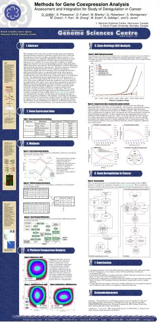
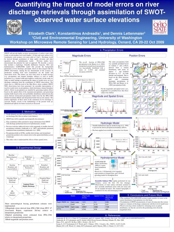
Quantifying the impact of model errors on river discharge retrievals through assimilation of SWOT-observed water surface elevations Elizabeth Clark1, Konstantinos Andreadis1, and Dennis Lettenmaier1 1Civil and Environmental Engineering, University of Washington Workshop on Microwave Remote Sensing for Land Hydrology, Oxnard, CA 20-22 Oct 2009 Perturbed Boundary and Lateral Inflows Baseline Boundary and Lateral Inflows Perturbed Meteorological Data Baseline Meteorological Data Baseline Model Parameters Updated Water Depth, Discharge Baseline Water Depth and Discharge Perturbed Water Depth and Discharge “Observed” WSL 1. Abstract 4. Precipitation Errors SWOT will provide highly accurate measurements of surface water slope (order on microradian over reach lengths 1-10 km) and water surface level (centimetric scale accuracy over areas order of 1 km2). Discharge would be derived through assimilation of slope and/or elevation and other quantities into a hydrodynamic model. Previous studies have demonstrated the potential for such an approach. We describe a system that includes a hydrology (Variable Infiltration Capacity, VIC) and hydrodynamics (LISFLOOD) model that provide the background predictions of river discharge and depth, which are then merged with the SWOT observations. Among the key determinants of the accuracy of predictions resulting from such assimilations are the model and observation errors. The former can arise from errors in model forcings (e.g. precipitation and channel boundary inflows) as well as model parameters (e.g. channel width and roughness coefficient). In this study we make an initial attempt at quantifying the impact of model errors on river discharge estimation from the assimilation of SWOT observations. The study area is a 1000 km reach of the Ohio River, where synthetic SWOT WSL observations have been generated. An ensemble representation is used for model errors in precipitation, which determines channel boundary inflows. Errors in precipitation are modeled by generating random offsets based on the spatial offset of the maximum precipitation, and generating random fields based on the error probability distribution inferred from the errors between downscaled precipitation fields from the the IPSL-CM4 Global Circulation Model and interpolated fields from in-situ stations. The relative importance of these errors in the estimation of river discharge is assessed. Finally, caveats in the methodology of the present work are identified and options for future research are discussed. Magnitude Errors Position Errors The entire precipitation field was spatially perturbed based on random x- and y-offsets derived from a normal distribution with mean of approx. 1° and standard deviation of ~2.5° for both latitude and longitude. This is based on the offset between grid cells containing maximum precipitation in IPSL-CM4 and Maurer et al. (2002) precipitation fields. The at-cell fraction of IPSL-CM4 precipitation to the Maurer et al. (2002) interpolated ground-based precipitation was log-normally distributed with a mean of11.56% and standard deviation of 69.93%. 1.0 Empirical 0.8 Fitted 0.6 CDF 0.4 0.2 0 -5 0 5 Fract. GCM to interpolated precip “Truth” (Maurer et al., 2002) Ensemble member For the magnitude and spatial errors case, magnitude was perturbed first, then these values were shifted. Precipitation Magnitude and Spatial Errors “Truth” (Maurer et al., 2002) Ensemble member 2. Motivation • Swath altimetry provides measurements of water surface elevation but not discharge (key flux in surface water balance) • SWOT data will be spatially and temporally discontinuous • Data assimilation offers potential to merge information from SWOT with discharge predictions from river hydrodynamics models • Previous work has addressed errors in the magnitude of satellite derived-precipitation estimates (Andreadis et al., 2007) and hydraulic parameter estimation from assimilation (Andreadis et al., 2008) • Precipitation fields in GCMs, satellite-derived data, and interpolated ground data products also contain errors in the spatial distribution across a landscape. • This study seeks to understand the effects of these spatial errors. “Truth” (Maurer et al., 2002) Ensemble member Hydrologic Model • Variable Infiltration Capacity model (Liang et al., 1994) to provide the lateral and upstream boundary inflows • Has been applied successfully in numerous river basins “Truth” (Maurer et al., 2002) “Truth” (Maurer et al., 2002) “Truth” (Maurer et al., 2002) Ensemble member Ensemble member Ensemble member 3. Experimental Design Hydrodynamics Model Open loop discharge Open loop water depth • LISFLOOD-FP (Bates and De Roo, 2000) is a raster-based inundation model. Hydrologic Model • Based on a 1-D kinematic wave equation representation of channel flow, and 2-D flood spreading model for floodplain flow. EnKF discharge EnKF water depth Ensemble Kalman Filter update performed for one overpass, across the first 352 km chainage. Observations of water surface elevation assumed to have normally distributed errors with zero mean and 20 cm standard deviation. The channel topography is assumed to be true and unchanging in time. Hydrodynamics Model 5. Conclusions and Future Work • The combined VIC-LISFLOOD system is quite sensitive to errors in the spatial distribution of precipitation over this basin. • Assimilation of SWOT measurements of water elevation into this system improves estimates of discharge commiserate with the level of model error. • Need to develop a better method for estimating errors in spatial distribution, one that de-convolves the positioning errors from the magnitude errors. JPL SWOT Simulator Kalman Filter • Three meteorological forcing perturbation schemes were implemented: • Magnitude errors derived from IPSL-CM4 (from IPCC 4th Assessment Report, experiment 20c3m) relative to interpolated ground data • Spatial positioning errors estimated from IPSL-CM4 relative to interpolated ground data • Both magnitude and position errors 6. References Andreadis, K. M., E. A. Clark, D. P. Lettenmaier, and D. E. Alsdorf, 2007, Geophys. Res. Lett., 34, L10403, doi:10.1029/2007GL029721. Andreadis, K., D. Lettenmaier, and D. Alsdorf, ASLO Ocean Sciences Meeting, Orlando, FL, Mar. 2008. Bates, P. D., and A.P.J. De Roo, 2000, J. Hydrol., 236, 54-77. Liang, X., D. P. Lettenmaier, E. F. Wood, and S. J. Burges, 1994, J. Geophys. Res., 99(D7), 14,415-14,428. Maurer, E.P., A.W. Wood, J.C. Adam, D.P. Lettenmaier, and B. Nijssen, 2002, J. Climate 15, 3237-3251.