Download
1 / 22
220 likes | 242 Views
Learn about aquifers, aquitards, groundwater movement, pumping scenarios, types of water rights, and considerations when reviewing applications to change water rights in Washington State. Geologists and hydrogeologists play a crucial role in evaluating geologic/hydrologic factors. Decisions regarding water rights can be complex and may involve impairments, requiring thorough geologic evaluations.

E N D
Hydrogeology and Water Right Changes Danielle Jansik Squeochs, PhD, LHg, LG, EIT Environmental Engineer/Hydrogeologist Central Regional Office, Washington State Department of Ecology Modified from previous presentations prepared by Anna Hoselton and Christine Neumiller
Aquifers and Aquitards • Aquifer: layer of geologic material that transmits water relatively easily - like sand, gravel, basalt flow tops & bottoms, well sorted sandstone… • Aquitard or Confining Layer: layer of geologic material that transmits water very slowly - like clay or dense rock
Idealized Aquifer System Timescales USGS C1139
Unconfined and Confined Aquifers USGS C1139
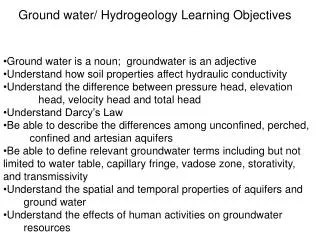
Groundwater Movement • Water passes through different types of geologic material with varying degrees of ease (or resistance) • Hydrogeologists refer to this property as “Hydraulic Conductivity”
Hydraulic ConductivityVaries by Sediment/Rock Type Gravel Low Hydraulic Conductivity (High Resistance to Flow) High Hydraulic Conductivity (Low Resistance to Flow) Basalt Dense Interior, Granite, etc Vesicular Basalt (Primarily flow tops and bottoms ) Sand Sandstone Silt Silt-Clay Rich Sedimentary Interbed Shale, Mudstone
Ground Water and Surface Water Interaction Gaining Stream • Baseflow - The component of streamflow derived from ground water inflow or discharge Loosing Stream USGS C1139
Pumping Scenarios • Capture Groundwater • Capture Surface water • Well interference
Pumping a WellForms a Capture Zone or “Cone of Depression” Unconfined Confined
How does the hydrogeology affect decisions when reviewing an application to change an existing water right?
Types of Existing Rights • Senior and Junior certificates • Permits • Claims • Tribal and Federal Reserves • Instream Flows
“Tests” to Consider When Reviewing an Application to Change a Water Right • Is there a right to change? • Will the change enlarge or enhance the right? • Will the change cause impairment to existing rights? • For Groundwater to Groundwater changes, will the source remain in the same body of public ground water? • For Surface water to Groundwater changes: • Will the right be transferred within the same sources? • From RCW 90.03 and 90.44
Same Body of Public Groundwater • An aquifer can have boundaries that divide it into separate ground water bodies. Boundaries can be caused by: • Folds • Faults • The local absence of an otherwise regional aquifer • Other geologic phenomena such as layered aquifer systems
Impairment • Can occur when changing an existing regulated right. For example: • An existing adjudicated class 5 surface water right is to be changed to a groundwater withdrawal. The proposed well is situated where it will only capture ground water flowing in the direction of the regulated surface water body. The well will be regulated as if it were the original surface water right. Why might this be considered a potential impairment?
Impairment • Can occur with the “direction” of a change. • For example: A right holder wishes to move a groundwater withdrawal up-stream to another field. There is an existing senior right in-between the present diversion and the proposed diversion. The total creek flow is, at times, unable to satisfy the senior right. Can this change request be authorized?
Geologic/Hydrologic Evaluation • Conducted by Geologists and Hydrogeologists licensed to practice in the State of Washington (RCW 18.220; WAC 308-15), using various tools such as: • Field Inspection, comparison of groundwater elevations, water chemistry, etc. • Conceptual Models • Analytical Models • 2 and 3-D Numerical Models
Geologist / Hydrogeologist Final Submittals (on Behalf of an Applicant) • Should assist the Boards in addressing Geologic / Hydrogeologic issues. • Should/will be reviewed by Ecology Hydrogeologists for completeness and fully addressing the issues. • Should bear the stamp of the Professional in Responsible Charge(RCW 18.220, WAC 308-15).
Decisions Can Be Complicated • Work with the applicant to get qualified technical assistance for the given situation • Consult with Ecology technical staff • Good luck with your efforts !
Questions? www.pacificcreststock.com
How Geology Affects Decisions • Folds: Major Anticlines such as those in the Yakima Fold Belt create sub-basins within larger basins by forming ground water divides. • Faults: Faults can inhibit ground water movement. Faults can bring two different rock types (and aquifer types) into contact, such as the Leavenworth fault. • Local Absence: For example, the Saddle Mountain basalts and associated aquifer may not be present in some areas. In other areas, both the Saddle Mountain basalts and the Wanapum basalts may be missing, but the Grande Ronde is present • Other Geologic Phenomena: For example, layered systems in which the aquifers can be distinguished as well separated and distinct units.
Interference vs. Impairment • Well interference occurs when the pumping of one well causes a lowering of the ground water level in another well. • Would well interference that may lower the ground water level in another well by 25 feet be considered an impairment ? • Case A: The affected well fully penetrates the aquifer and a saturated thickness of 300 feet. • Case B: The affected well fully penetrates the aquifer and a saturated thickness of 40 feet. • Case C: The affected well partially penetrates the aquifer and a saturated thickness of 40 feet.