Download
1 / 20
240 likes | 854 Views
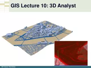
ArcGIS 3D Analyst: Working with 3D Analyst and CityEngine. Nathan Shephard, Gert van Maren. Why 3D GIS?. Because our world is 3D. Improve understanding 3D is easy for everyone to understand Better communication 3D makes it easier to articulate ideas

E N D
ArcGIS 3D Analyst:Working with 3D Analyst and CityEngine Nathan Shephard, Gert van Maren
Why 3D GIS? Because our world is 3D • Improve understanding3D is easy for everyone to understand • Better communication3D makes it easier to articulate ideas • Solve 3D problemsSome spatial problems can only be solved in 3D CityEngine: An Introduction
3D GIS Features 3D Geodesign Multiscale 3D Models ArcGIS for 3D Cities Surface modeling Share 3D scenes Native lidar support 3D Analysis Integrated 3D Type Presentation Title Here
Share 3D Scenes Type Presentation Title Here
Share your 3D Scenes Supporting Defense, Local Government, Scientists, Urban Planners, Facilities Managers, Geologists, Architects, Landscape Planners… Share your ArcScene Project as a Web Scene “Clip and Share” Web Scene ArcScene Web Scene ArcScene ArcGIS 3D Analyst: Working with 3D Analyst and CityEngine
GP: Export to 3D Web Scene ArcGIS 3D Analyst: Working with 3D Analyst and CityEngine
Demo Teapot Dome Philadelphia Visibility / Shadows ArcGIS 3D Analyst: Working with 3D Analyst and CityEngine
ArcScene Layer Types • Feature layer (point, line, polygon and multipatch geometries) • Layer extrusion or 3D symbology • Raster layer • TIN layer • Note: LAS dataset and Graphics layer cannot be exported to 3ws. ArcGIS 3D Analyst: Working with 3D Analyst and CityEngine
ArcScene document properties • Scene coordinate system • Area of Interest (AOI) • Bookmarks • Group Layers • Vertical exaggeration ArcGIS 3D Analyst: Working with 3D Analyst and CityEngine
Creating 3D objects in ArcGIS • In ArcGIS 10.1 • Via symbology (eg: point symbols) • Using GP tools (eg: Buffer 3D) • Importing external models (eg: COLLADA) • In ArcGIS 10.1 • Via symbology (eg: point symbols) • Using GP tools (eg: Buffer 3D) • Importing external models (eg: COLLADA) • In ArcGIS 10.2 • Using pre-authored CityEngine rule packages • In CityEngine • Using pre-authored CityEngine rules • Writing / adjusting new rules • Interactively editing new 3D models • In ArcGIS Pro • Use CityEngine rule packages as ‘advanced symbology’
GP: Features From CityEngine Rules Gert van Maren
Supported Layer Types At 10.2, polygon and multipatches only Buildings (real and imagined) Zoning regulations Cartographic symbols … Line support (eg: for streets) is coming later Until then, export features from CityEngine Gert van Maren
Demo ArcScene & CityEngine Generating 3D content using a Rule Package • …for existing features • …as part of an editing / design effort • …with updated textures • …by adjusting / authoring the rule logic
ArcGIS Pro Procedural symbols (from CityEngine) Rule Package (RPK)
Demo ArcGIS Pro Displaying 3D content using a Rule Package • …for existing features • …configuring to a custom data model • …as part of an in-progress GIS work
SUMMARY: Working with CE Rules (RPK’s) in ArcGIS • Author CE rules inside CityEngine • Where possible, author rules against the expected data model • Optionally, export new 3D content directly from CityEngine • Share CE rules with others • Via ArcGIS Online, or as RPK files on disk • Limit access to the underlying logic, as needed • Create new 3D content via the ‘Features from CE Rules’ GP Tool • Available with GP - in ArcScene, ArcGlobe, and ArcMap • Symbolize features directly inside ArcGIS Pro • Configure rule parameters to link them to feature attributes ArcGIS 3D Analyst: Working with 3D Analyst and CityEngine
Demo CityEngine Creating new models by sketching and rules • …interactive push/pull of the 3D shape • …add procedural textures using a CE rule • …export as a 3D feature
Thank you… Please fill out the session survey: First Offering ID: 1644 Online – www.esri.com/ucsessionsurveys Paper – pick up and put in drop box ArcGIS 3D Analyst: Working with 3D Analyst and CityEngine