Download
1 / 25
250 likes | 567 Views
Purpose. To understand the processes responsible for initiating, organizing, and maintaining convective systems that produce excessive rainfall and lead to flash floodingTo investigate convective systems that initiate near midlevel circulations (such as mesoscale convective vortices) and remain nea

E N D
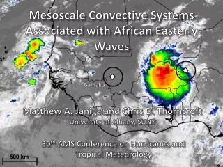
1. Flash-Flood-Producing Convective Systems Associated with Mesoscale Convective Vortices Russ S. Schumacher
Department of Atmospheric Science, Colorado State University and
National Center for Atmospheric Research
2. Purpose To understand the processes responsible for initiating, organizing, and maintaining convective systems that produce excessive rainfall and lead to flash flooding
To investigate convective systems that initiate near midlevel circulations (such as mesoscale convective vortices) and remain nearly stationary for 6-12 hours
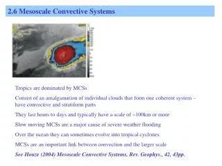
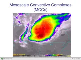
3. Background: MCVs Latent heating in mesoscale convective systems (MCSs) redistributes potential vorticity (PV), sometimes resulting in a positive PV anomaly (and cyclonic circulation) at midlevels, referred to as a mesoscale convective vortex (MCV)
Raymond and Jiang (1990) showed how MCVs in shear can initiate and/or maintain convection via isentropic upglide on the downshear side of the vortex
Trier et al. (2000) showed that this lifting also leads to destabilization and moist absolutely-unstable layers
When a low-level jet approaches the MCV, the downshear side is upwind: convection that develops moves slowly (e.g., Fritsch et al. 1994)
4. Background: MCVs and heavy rainfall Bosart and Sanders (1981), Fritsch et al. (1994), and Trier and Davis (2002) studied significant flash flood events near MCVs
Fritsch et al. showed that when a strong low-level jet approaches the MCV, convection is favored near the center of the vortex
This leads to slow system motion and heavy rainfall
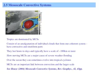
6. Case selection We identified six warm-season extreme rain events associated with MCVs or other midlevel circulations
The selection of cases was somewhat subjective, but all had the following in common:
Gauge-observed rainfall in excess of 200 mm (7.9 in) in less than 12 hours
Heavy rainfall produced by a convective system that had �back-building/quasi-stationary� organization at some point
The presence of a preexisting midlevel circulation near where the convection developed
Flash flooding resulting from the rainfall
7. 6-7 May 2000 Max rainfall: 309 mm (12.1 in); 2 fatalities and $100M in damage
Analyzed in Schumacher and Johnson (2008, MWR, Oct. issue)
8. 6-7 May 2000 MCS Surface observations and WRF simulations reveal a convectively-generated mesolow and pressure trough, no cold pool
More details: see Schumacher and Johnson (2008), MWR, October issue
9. 20 August 2007 Formed from remnants of TS Erin after surface low weakened
Max rainfall: 266 mm (10.5 in); most damage was to rural roads
10. 25 June 2008 Occurred after we performed the analysis, but fits the bill�
Max rainfall: 219 mm (8.6 in)
11. Soundings
12. Composite analysis: Midlevel vorticity Composites computed from RUC 0-h analyses, centered at location of maximum rainfall
Results projected onto a map centered at Springfield, MO (black box denotes heavy rainfall location)
Average vorticity in the 700-500-hPa layer, 600-hPa heights and winds
13. Composite: Midlevel vorticity & LLJ
14. Composite CAPE & CIN Little CAPE in heavy rain area in the afternoon
LLJ brings high-?e air into area, and vortex-related destabilization also takes place
By the time the MCS develops, over 1000 J/kg of CAPE and no CIN
15. Composite sounding Calculated at RUC grid point and time nearest heavy rainfall
Stable near surface, but elevated parcels have 1149 J/kg of CAPE and no CIN
Nearly saturated at low levels; PW=49 mm (1.93�)
~15 m/s LLJ and weak midlevel winds produces �hairpin� hodograph � shear vector turns sharply with height
16. Summary: Extreme rainfall near MCVs
17. Conclusions Analyzed 6 events where extreme local rainfall (>200 mm) occurred near a midlevel cyclonic circulation
Lifting associated with the interaction between a strong low-level jet and the midlevel vortex helped to initiate and maintain deep convection
Strong LLJ, weak midlevel winds ? �hairpin� hodograph
Thermodynamic environment: very high RH, moderate CAPE, little CIN; destabilized by vortex-related lifting
20. Background: MCVs in shear Raymond and Jiang (1990) described how MCVs (or other midlevel PV anomalies) in shear can help to initiate and/or maintain additional convection via isentropic upglide on the downshear side of the vortex
Trier et al. (2000) showed that this region is destabilized and that moist absolutely unstable layers (MAULs; Bryan and Fritsch 2000) can form by the lifting of conditionally unstable air to saturation
21. Operational Model QPF
22. Operational Model QPF
23. Rainfall totals
24. Summary: 6-7 May 2000 MCS
25. Parcel trajectories along gravity wave
26. Observational evidence These MCSs are small, so they don�t often pass over a surface station
The 20 August 2007 case does provide some evidence for these waves