Download
1 / 21
240 likes | 630 Views
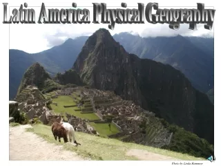
Physical Geography Mexico, Central America, Caribbean, South America. Honors World Geography. Mexico Landforms. Mexico is a large country 3 times the size of Texas Most of the country is made up of a rugged central plateau, called the Mexican Plateau Can be as high as 9,000 feet

E N D
Physical GeographyMexico, Central America, Caribbean, South America Honors World Geography
Mexico Landforms • Mexico is a large country • 3 times the size of Texas • Most of the country is made up of a rugged central plateau, called the Mexican Plateau • Can be as high as 9,000 feet • 3 mountain ranges border the Mexican Plateau: • Sierra Madre Oriental in the east (1) • Sierra Madre Occidental in the west (2) • Sierra Madre del Sur in the south (3)
Mexico Landforms continued • Valley of Mexico • At the southern end of then Mexican Plateau • Mexico City located here • The floor of this broad valleyis about 7500 feet above sea level • can cause a shortness of breath and a lack of energy due to the thin air • Mexico narrows to the south to form an isthmus • Isthmus: Narrow strip of land connecting two large land areas w/ water located on both sides • Isthmus of Tehuantepec
Mexico Landforms continued • The Pacific Ocean & the Gulf of Mexico lie just about 150 miles apart at Mexico’s Isthmus of Tehuantepec • Yucatan Peninsula • Mexico’s flattest region • Limestone lies beneath the surface • Erosion has created many caves and sinkholes in the area • Sinkhole: Steep-sided depression that forms when the roof of a cave collapses
Mexico Climate • 3 Factors that help explain Mexico’s climate: • High pressure weather system creates a dry arid climate w/ little rainfall in NW Mexico (1) • Trade winds from the Gulf of Mexico/Caribbean Sea bring much rainfall to the SE (2) • Elevation produces varied climates in mountainous regions (3)
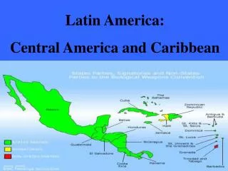
Central America/Caribbean Landforms • Central America is an isthmus that links North & South America • Pacific Ocean lies to west, West Indies lie to the east • West Indies • Include the Greater Antilles/Lesser Antilles • Greater Antilles: Cuba, Hispaniola, Jamaica, Puerto Rico • Hispaniola: Dominican Republic/Haiti • Lesser Antilles: 20 small island countries • Narrow coastal plains found in Caribbean/Central America
Central America/Caribbean Landforms continued • Rugged hills/mountains lie in the interior • Travel/communication can be difficult • Tectonic forces shape both regions • Central America, Jamaica, Hispaniola, Puerto Rico lie on Caribbean plate • Cocos Plate dives beneath Caribbean plate • Created mountains • Some areas of Caribbean have active volcanoes • Martinique formed from volcanoes
Central America/Caribbean Climate/Vegetation • Sunny & warm tropical climates • Tropical & wet dry climates typical • temperatures seldom vary more than 10° between summer & winter • During winter, high pressure brings dry weather • A summer rainy season happens when low pressure cells begin to move north across the region • In Central America, the climate zones follow the terrain
Central America/Caribbean Climate/Vegetation continued • the Caribbean coast gets the full effect of the moist trade winds • Dense forests are common • Eastern side of mountain gets heavy rain as moist air rises & cools • Mountain valleys in west usually lie in the rain shadow • Throughout the Caribbean, elevation greatly affects climate • Mangrove-type of tree with roots that grow in saltwater; found in tropical coastal areas of the world
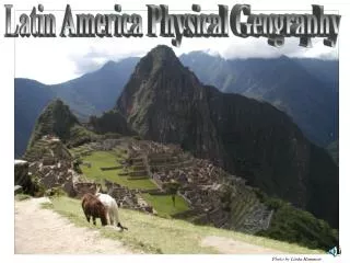
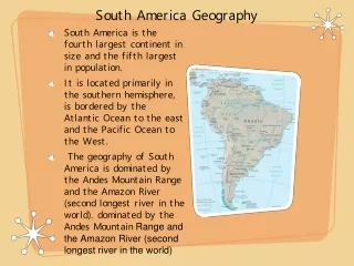
South America Landforms • Andes Mountains • South America’s great mountain range • extends along the continent’s Pacific coast • Tectonic activity causes volcanic eruptions & earthquakes • Altiplano-lies between the Andes Mts. • Means “High Plateau” • 12,000 feet above sea level
South America Landforms continued • Plains cover much of South America • The largest plain is the Amazon River Basin • Llanos-N.E. Colombia/western Venezuela---means plains in Spanish • Gran Chaco-Between Andes/Brazilian Highlands---chaco means hunting land • Pampas • wide grasslands • At eastern edge is Argentina’s most densely populated area
South America/Bodies of Water • Lake Titicaca • freshwater lake located on the border of Peru & Bolivia • 3,200 square miles • 3 Major River Systems in S. America • Amazon (1) • World’s largest river in volume • Orinoco (2) • Paraná (3)
South American Climate • 5 Elevation Zones of the Andes: • Tierra helada-above 16,000 ft.---permanently covered in snow • Paramo-10,000 to 16,000 ft. • Tierra fria-6,000 to 10,000 ft • Tierra templada-3,000 to 6,000 ft. • Tierra Caliente- sea level to 3,000 ft.