Download
1 / 89
890 likes | 1.02k Views
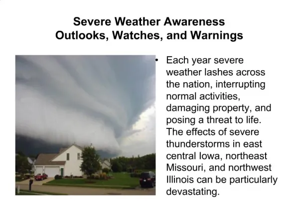
Early warnings for severe weather. Tim Hewson. Severe weather in Europe. Structure of Talk. 1. Cyclone products ( nwmstest.ecmwf.int/products/forecasts/ cdb / ) Brief overview – principles, identification and tracking

E N D
Early warnings for severe weather Tim Hewson FPU meeting 9 June 2010 “Early warnings for severe weather“ Tim Hewson
Severe weather in Europe FPU meeting 9 June 2010 “Early warnings for severe weather“ Tim Hewson
Structure of Talk • 1. Cyclone products (nwmstest.ecmwf.int/products/forecasts/cdb/) • Brief overview – principles, identification and tracking • The products - improvements made in the last year (based partly on direct user feedback) and future plans • Storm examples from winter 2009/10 • Verification of cyclone handling during winter 2009/10 – deterministic and 3 EPS systems • How can the forecaster make use of verification statistics? • 2. EFI products • Brief overview • Issues related to the model climate, and future plans • 3. Summary FPU meeting 9 June 2010 “Early warnings for severe weather“ Tim Hewson
1. Cyclonic Features FPU meeting 9 June 2010 “Early warnings for severe weather“ Tim Hewson
A. Principles • Provision of warnings of severe weather is a key task for NMS’s, and assisting with this goal is a key target for ECMWF • There are direct connections between severe (or extreme) weather and synoptic features (e.g. fronts, frontal waves, lows), which forecasters make daily use of • So automating feature identification in a manner consistent with operational practice provides: • 1. A range of EPS-based real-time tools for assisting the forecaster in warning of adverse weather (Products) • 2. A means by which real-time forecasts of adverse weather can be verified, by proxy, by comparing the forecast features with features identified in model analyses (Verification). This proxy approach nicely circumvents verification problems related to surface data availability and reliability. We verify as much over data sparse regions, including the oceans; intrinsically this (i) increases the number of severe events we verify, making results more reliable, and (ii) normalises data density. FPU meeting 9 June 2010 “Early warnings for severe weather“ Tim Hewson
B. Identification of Cyclonic Features • Overall methodology is based around this conceptual model of extra-tropical cyclone development (but is not constrained by it): FPU meeting 9 June 2010 “Early warnings for severe weather“ Tim Hewson
Diminutive Wave (weak) Barotropic Low Frontal Wave (weak) Frontal Wave Diminutive Wave Example SnapshotCyclonic Features, Mslp, Objective fronts FPU meeting 9 June 2010 “Early warnings for severe weather“ Tim Hewson
C. Tracking cyclonic features • In tailoring algorithms special attention was paid to the evolutionary behaviour of windstorm-generating cyclones. Typical characteristics catered for include: • Originate on fronts – frontal wave or diminutive wave • Rapid movement (beneath strong upper level jets) • Rapid decelleration (in the jet’s left exit) • Can be very small-scale • Can be very short-lived (<24h) • All details of the methodology can be found in Hewson and Titley, 2010 (Met Apps, now in press) FPU meeting 9 June 2010 “Early warnings for severe weather“ Tim Hewson
D. Forecast Products Based on the 50-member ensemble + control and deterministic runs i) Feature-related ii) Track-related FPU meeting 9 June 2010 “Early warnings for severe weather“ Tim Hewson
i) Feature-related products FPU meeting 9 June 2010 “Early warnings for severe weather“ Tim Hewson
Snapshot of Synoptic Feature Chart NEW - 1000-500mb thickness lines added NEW - Deterministic run now available Single forecast run FPU meeting 9 June 2010 “Early warnings for severe weather“ Tim Hewson
Fronts Spaghetti Plot EPS + Control + Deterministic NEW - Deterrministic run added FPU meeting 9 June 2010 “Early warnings for severe weather“ Tim Hewson
Fronts Spaghetti Plot EPS + Control + Deterministic FPU meeting 9 June 2010 “Early warnings for severe weather“ Tim Hewson
Postage stamps (various options) NEW - Deterministic run added FPU meeting 9 June 2010 “Early warnings for severe weather“ Tim Hewson
Dalmatian Chart (feature type) NEW - Deterministic run added FPU meeting 9 June 2010 “Early warnings for severe weather“ Tim Hewson
NEW Dalmatian Chart (mslp) FPU meeting 9 June 2010 “Early warnings for severe weather“ Tim Hewson
NEW Dalmatian Chart (max 1km wind, 300km radius) FPU meeting 9 June 2010 “Early warnings for severe weather“ Tim Hewson
NEW Dalmatian Chart (1000-500mb thickness) FPU meeting 9 June 2010 “Early warnings for severe weather“ Tim Hewson
NEW Dalmatian Chart (max 1km wind, 600km radius) 52 forecast runs (EPS + Control + Deterministic) FPU meeting 9 June 2010 “Early warnings for severe weather“ Tim Hewson
Soon Revised Feature chart (with ppn) (shading shows rain, sleet, snow totals; thresholds 2 / 8 / 20 / 50mm in 12hours) Single deterministic forecast run FPU meeting 9 June 2010 “Early warnings for severe weather“ Tim Hewson
Soon Clickable dalmatian chart • Enables the user to select a ‘representative member’ or an ‘extreme member’ (prototype in place), or just examine many different members • User feedback required on what effect the users would like to see “hovering” and “clicking” have… • At present hovering shows just the EPS member, clicking brings up the corresponding synoptic chart Live Demo FPU meeting 9 June 2010 “Early warnings for severe weather“ Tim Hewson
Planned: • Dalmatian plots that show the temporally (-6 to +6h) and areally (300km radius) integrated ppn totals (rain and/or snow) within rings around each cyclonic feature • Precipitation is thereby associated with features (as in forecasting) • This will extend application into warnings of heavy rainfall, flooding, snowfall, blizzards, etc • Feature plume diagrams may also show this as an attribute • Distinction may be made between rain and snow • Dalmatian chart that shows rate of deepening in previous or upcoming 12 hours (by blending with feature tracking attributes) FPU meeting 9 June 2010 “Early warnings for severe weather“ Tim Hewson
ii) Track-related Products FPU meeting 9 June 2010 “Early warnings for severe weather“ Tim Hewson
Interactive selection of specific weather systems from T+0 User clicks on any spot at T+0 (= cyclonic feature) to see how that feature evolves in the EPS FPU meeting 9 June 2010 “Early warnings for severe weather“ Tim Hewson
NEW - Deterministic run added User can click on track plot, to animate ‘Plume’ diagrams FPU meeting 9 June 2010 “Early warnings for severe weather“ Tim Hewson
NEW - Deterministic run added Starburst animation FPU meeting 9 June 2010 “Early warnings for severe weather“ Tim Hewson
Strike Probability Plot – for feature tracks- ‘moderate intensity features’ (34kt threshold) (EPS only) FPU meeting 9 June 2010 “Early warnings for severe weather“ Tim Hewson
Strike Probability Animations (15 day)- three thresholds (DT 12Z 25/2/2010) 51 forecast runs (EPS only) FPU meeting 9 June 2010 “Early warnings for severe weather“ Tim Hewson
NEW Strike prob postage stamps FPU meeting 9 June 2010 “Early warnings for severe weather“ Tim Hewson
NEW Strike prob postage stamps FPU meeting 9 June 2010 “Early warnings for severe weather“ Tim Hewson
NEW Links back to main forecast products web page FPU meeting 9 June 2010 “Early warnings for severe weather“ Tim Hewson
Ideas for the future: • Vectors may be added to denote an “average” direction of movement for features on the strike prob plots • Single lines may be added to show tracks in the deterministic run • As well as strike probs based on wind thresholds, the new precipitation attribute could be used, separately, to define strike probs for systems producing substantial areally-integrated 12h rainfall (above set thresholds), and/or snowfall – “track of rainstorms” FPU meeting 9 June 2010 “Early warnings for severe weather“ Tim Hewson
Tracking improvements ? • Though performance of the tracking system compares very favourably with other systems, very occasionally some issues arise – e.g. a feature may not be tracked to the next frame time when it should be • There is scope for making subtle adjustments, based on matching distances, to the tracking parameters • in particular the appropriateness of the steering wind assumption needs checking – is 60% of the 500mb wind appropriate ? • could this be changed depending on system type ? • subjective evidence suggests that this is appropriate for frontal waves, but may be less appropriate for barotropic lows • identical changes would of course be made to tracking of analysed features (for verification) FPU meeting 9 June 2010 “Early warnings for severe weather“ Tim Hewson
E. Windstorm Examples FPU meeting 9 June 2010 “Early warnings for severe weather“ Tim Hewson
Portugal Storm example – “Xola” “Micro-storm” 23 Dec 2009 00 UTC 23 Dec 2009 04 UTC 967 FPU meeting 9 June 2010 “Early warnings for severe weather“ Tim Hewson
Synoptic animation FPU meeting 9 June 2010 “Early warnings for severe weather“ Tim Hewson
24h lead plumes FPU meeting 9 June 2010 “Early warnings for severe weather“ Tim Hewson
12h lead plumes Observed FPU meeting 9 June 2010 “Early warnings for severe weather“ Tim Hewson
Portuguese Windstorm – “Xola” • The ECMWF forecast system failed to capture the full intensity of the storm, partly because of its small scale • However the cyclone tracking facility did provide some clear pointers to: • The potential for rapid intensification • The feature being small scale • High uncertainty (associated in part with a strong upper level jet – akin to Lothar in France in Dec 1999) FPU meeting 9 June 2010 “Early warnings for severe weather“ Tim Hewson
300mb isotachs and mslp – analysis – 00Z 23/12/09 FPU meeting 9 June 2010 “Early warnings for severe weather“ Tim Hewson
“Xynthia” – 27-28 Feb 2010 FPU meeting 9 June 2010 “Early warnings for severe weather“ Tim Hewson
Synoptic animation FPU meeting 9 June 2010 “Early warnings for severe weather“ Tim Hewson
Dalmatian chart – max 1km wind in 600km radius 8 days FPU meeting 9 June 2010 “Early warnings for severe weather“ Tim Hewson
Dalmatian chart – max 1km wind in 600km radius 7.5 days FPU meeting 9 June 2010 “Early warnings for severe weather“ Tim Hewson
Dalmatian chart – max 1km wind in 600km radius 7 days FPU meeting 9 June 2010 “Early warnings for severe weather“ Tim Hewson
Dalmatian chart – max 1km wind in 600km radius 6.5 days FPU meeting 9 June 2010 “Early warnings for severe weather“ Tim Hewson
Dalmatian chart – max 1km wind in 600km radius 6 days FPU meeting 9 June 2010 “Early warnings for severe weather“ Tim Hewson
Dalmatian chart – max 1km wind in 600km radius 5.5 days FPU meeting 9 June 2010 “Early warnings for severe weather“ Tim Hewson
Dalmatian chart – max 1km wind in 600km radius 5 days FPU meeting 9 June 2010 “Early warnings for severe weather“ Tim Hewson
Dalmatian chart – max 1km wind in 600km radius 4.5 days FPU meeting 9 June 2010 “Early warnings for severe weather“ Tim Hewson