Download
1 / 59
590 likes | 849 Views
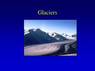
How do Glaciers affect the land?. WED V17. What is a glacier?. A large, long-lasting mass of ice which forms on land and moves downslope because of gravity. What metaphors do we use for glaciers?. Glaciers are often referred to as a River of Ice or Bulldozer of Ice. How do glaciers form?.

E N D
How do Glaciers affect the land? WED V17
What is a glacier? • A large, long-lasting mass of ice which forms on land and moves downslope because of gravity.
What metaphors do we use for glaciers? • Glaciers are often referred to as a River of Iceor • Bulldozerof Ice
How do glaciers form? Glaciers form over many years in places where the snowfall in winter exceeds the snow melt in summer Gravity pulls the ice down the hill
http://www.swisseduc.ch/glaciers/earth_icy_planet/icons-11/20.jpghttp://www.swisseduc.ch/glaciers/earth_icy_planet/icons-11/20.jpg
What are the two types of glaciers? Alpine and Continental
Alpine Glaciers • A.k.a. Valley Glaciers • form near mountain tops and slide down the valleys • They can be hundreds of feet thick.
Aletsch Glacier, Switzerland115 sq miles http://travelguide.all-about-switzerland.info/pictures-famous-swiss-glaciers.html
Continental Glaciers • cover large areas (Antarctica, Canada) • can be 2 – 3 miles thick
Weight of the ice depresses the ground • When these glaciers melt the land ‘rebounds’ • Some areas depressed during the last ice age are still rising
http://www.prolitegear.com/prolitegear/images/large/antarctica_02_lg.jpghttp://www.prolitegear.com/prolitegear/images/large/antarctica_02_lg.jpg
http://exposedplanet.com/images/antarctica-group-sled-vinsonbc-camp1.jpghttp://exposedplanet.com/images/antarctica-group-sled-vinsonbc-camp1.jpg
http://exposedplanet.com/images/mountain-rangefrom-ph-antarctica.jpghttp://exposedplanet.com/images/mountain-rangefrom-ph-antarctica.jpg
What are the landscape features left by Alpine or mountain glaciers? • Till- direct deposit of glacier; unsorted sediment • Mountain shape: • Rugged landscapes • Jagged peaks • U-shaped valley • Moraine- a mass of till
Northeast-looking oblique aerial photograph showing the snow-covered summit accumulation area of Mount Fairweather, Fairweather Range, Glacier Bay National Park, Alaska.
Materhorn http://www.kuleuven.ac.be/geologie/geo-algemeen.html
West-looking photograph showing an angular arete ridge, composed of schist, on the upper Taku Glacier, Juneau Icefield, Tongass National Forest, Coast Mountains, Alaska.
River Valley Glacial Valley http://www.nps.gov/history/history/online_books/brochures/1936/glac/images/fig13c.jpg
Moraine • Mass of till (unsorted sediment) left by a glacier
http://www.yosemite.ca.us/library/geologic_story_of_yosemite/images/62.jpghttp://www.yosemite.ca.us/library/geologic_story_of_yosemite/images/62.jpg
The u-shaped valley to the right side of the photo is the ice-free valley of Talkeetna Glacier, Talkeetna Mountains, Alaska. Note cirque at the top of the valley on the left.
Aletsch Glacier, Switzerland http://travelguide.all-about-switzerland.info/pictures-famous-swiss-glaciers.html
What are the characteristics left by Continental Glaciers? • Valleys- u shaped • Till - unsorted sediment • Kettle lakes • Scratches and grooves • Drumlins
Kettle Lake http://www.scienceclarified.com/images/uesc_06_img0334.jpg
http://dnr.metrokc.gov/wlr/waterres/smlakes/LakeStewWeb25/GeoDrawing.JPGhttp://dnr.metrokc.gov/wlr/waterres/smlakes/LakeStewWeb25/GeoDrawing.JPG
Finger Lakes • streams and lakes were modified by glaciers • Retreating glaciers deposited recessional moraines that blocked the water flow and created deep lakes • Examples • Seneca lake: 40 miles long, 618 feet deep • Cayuga: 40 miles long, 435 feet deep
http://upload.wikimedia.org/wikipedia/commons/5/5f/Fingerlakesmap.pnghttp://upload.wikimedia.org/wikipedia/commons/5/5f/Fingerlakesmap.png
Striations (Scratches) http://images.google.com/imgres?imgurl=http://education.usgs.gov/schoolyard/IMAGES/GlacialStriations2.jpg&imgrefurl=http://education.usgs.gov/schoolyard/CoolGeologyActivity.html&h=297&w=447&sz=45&hl=en&start=1&tbnid=y1qmEFaxgJ64ZM:&tbnh=84&tbnw=127&prev=/images%3Fq%3Dglacial%2Bstriations%26gbv%3D2%26svnum%3D10%26hl%3Den
Polished Rock http://3dparks.wr.usgs.gov/nyc/images/fig21.jpg
Drumlin http://oz.plymouth.edu/~sci_ed/Turski/Courses/Earth_Science/Images/4.drumlin.jpg
A SWARM OF DRUMLINS http://www.drumlinarealandtrust.org/images/drumlins.jpg