Download
1 / 1
10 likes | 153 Views
Critical need for improved understanding and forecasting of tropical cyclone rapid intensification (RI) Key lifecycle observations of Hurricane Dennis (2005) from NASA Tropical Cloud Systems and Processes (TCSP) campaign for evaluation of numerical models and parameterization schemes

E N D
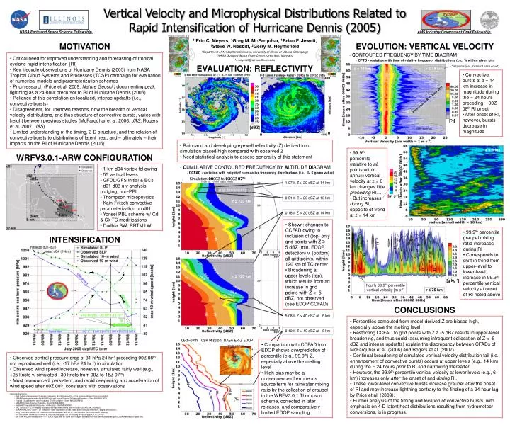
Critical need for improved understanding and forecasting of tropical cyclone rapid intensification (RI) • Key lifecycle observations of Hurricane Dennis (2005) from NASA Tropical Cloud Systems and Processes (TCSP) campaign for evaluation of numerical models and parameterization schemes • Prior research (Price et al. 2009, Nature Geosci.) documenting peak lightning as a 24-hour precursor to RI of Hurricane Dennis (2005) • Reliance of this correlation on localized, intense updrafts (i.e., convective bursts) • Disagreement, for unknown reasons, how the breadth of vertical velocity distributions, and thus structure of convective bursts, varies with height between previous studies (McFarquhar et al. 2006, JAS; Rogers et al. 2007, JAS) • Limited understanding of the timing, 3-D structure, and the relation of convective bursts to distributions of latent heat, and – ultimately – their impacts on the RI of Hurricane Dennis (2005) • Convective bursts at z = 14 km increase in magnitude during the ~ 24 hours preceding ~ 00Z 08th RI onset • After onset of RI, however, bursts decrease in magnitude [°C] [°C] -70 -70 -80 -80 -60 -60 [%] • Rainband and developing eyewall reflectivity (Z) derived from simulation biased high compared with observed Z • Need statistical analysis to assess generality of this statement • 99.9th percentile (relative to all points within annuli) vertical velocity at z = 6 km changes little preceding RI… • But increases during RI, opposite of trend at z = 14 km • 1-km d04 vortex-following • 55 vertical levels • GFDL/GFS initial & BCs • d01-d03 u,v analysis nudging, non-PBL • Thompson microphysics • Kain-Fritsch convective parameterization on d01 • Yonsei PBL scheme w/ Cd & Ck TC modifications • Dudhia SW; RRTM LW [m s-1] • Shown: changes to CCFAD owing to inclusion of (top) only grid points with Z ≥ -5 dBZ (min. EDOP detection) v. (bottom) all grid points, within 120 km of TC center • Broadening at upper levels (top), which results from an increase in grid points with Z < -5 dBZ, not observed (see EDOP CCFAD) • 99.9th percentile graupel mixing ratio increases during RI • Corresponds to shift in trend from upper-level to lower-level increase in 99.9th percentile vertical velocity at onset of RI noted above [g kg-1] • Percentiles computed from model-derived Z are biased high, especially above the melting level. • Restricting CCFAD to grid points with Z ≥ -5 dBZ results in upper-level broadening, and thus could (assuming infrequent collocation of Z < -5 dBZ and intense updrafts) explain the discrepancy between CFADs of McFarquhar et al. (2006) and Rogers et al. (2007). • Continual broadening of simulated vertical velocity distribution tail (i.e., enhancement of convective bursts) occurs at upper levels (e.g., 14 km) during the ~ 24 hours prior to RI and narrowing thereafter. • However, the 99.9th percentile vertical velocity at lower levels (e.g., 6 km) increases only after the onset of and during RI. • These lower-level convective bursts increase graupel after the onset of RI and may increase lightning contrary to the finding of a 24-hour lag by Price et al. (2009). • Further analysis of the timing and location of convective bursts, with emphasis on 4-D latent heat distributions resulting from hydrometeor conversions, is in progress. 1.07% Z > 20 dBZ at 14 km 5.08% Z > 40 dBZ at 6 km 0.18% Z > 20 dBZ at 14 km 0.10% Z > 40 dBZ at 6 km 0.51% Z > 20 dBZ at 13 km SSMI 85H 2302Z 06th • Comparison with CCFAD from EDOP shows overprediction of percentile (e.g., 99.9th) Z, especially above the melting level • High bias may be a consequence of erroneous source term for rainwater mixing ratio by the collection of graupel in the WRFV3.0.1 Thompson scheme, corrected in later releases, and comparatively limited EDOP sampling 18 • Observed central pressure drop of 31 hPa 24 hr-1 preceding 00Z 08th not reproduced well (i.e., -17 hPa 24 hr-1) in simulation • Observed wind speed increase, however, simulated fairly well (e.g., +25 knots v. simulated +30 knots from 00Z to 15Z 07th) • Most pronounced, persistent, and rapid deepening and acceleration of wind speed after 00Z 08th, consistent with observations 16 14 -76 -74 -72 -70 Vertical Velocity and Microphysical Distributions Related to Rapid Intensification of Hurricane Dennis (2005) NASA Earth and Space Science Fellowship AMS Industry/Government Grad Fellowship 07/06/05 1015Z GOES-12 IR 07/06/05 1345Z GOES-12 IR 1*Eric C. Meyers, 1Greg M. McFarquhar, 1Brian F. Jewett, 1Steve W. Nesbitt, 2Gerry M. Heymsfield MOTIVATION EVOLUTION: VERTICAL VELOCITY 1Department of Atmospheric Sciences, University of Illinois at Urbana-Champaign 2NASA Goddard Space Flight Center, Greenbelt, Maryland - CONTOURED FREQUENCY BY TIME DIAGRAM *emeyers3@atmos.illinois.edu • CFTD - variation with time of relative frequency distributions (i.e., % within given bin) EVALUATION: REFLECTIVITY *all points (i.e., invariant base count) z = 14 km r ≤ 75 km 07/06/05 1215Z GOES-12 IR 07/06/05 1445Z GOES-12 IR Precursor to RI (~ hour 48)? [dBZ] d04 spin-up z = 6 km WRFV3.0.1-ARW CONFIGURATION - CUMULATIVE CONTOURED FREQUENCY BY ALTITUDE DIAGRAM • CCFAD - variation with height of cumulative frequency distributions (i.e., % ≤ given value) Simulation 0000Z to 0300Z 07th (from 19, 10-min output times) e.g., broadening r ≤ 120 km INTENSIFICATION r ≤ 120 km hourly 99.9th percentile vertical velocity [m s-1] r ≤ 75 km CONCLUSIONS +40 knots, -35 hPa 15 hr-1 RI 06th-07th TCSP Mission, NASA ER-2 EDOP • Acknowledgements: • AMS Industry/Government Graduate Fellowship, Earth Science Div. of the Science Mission Directorate/NASA • NASA Headquarters under the NASA Earth and Space Science Fellowship Program – Grant NNX08AU92H • Tropical Cloud Systems and Processes (TCSP) mission - Grant NNG05GR61G • NASA Hurricane Science Program – Grant NNX09AB82G • TeraGrid Computational Resources – Allocation TG-ATM060008N • NRL (for GOES-12 IR imagery accessed via http://www.nrlmry.navy.mil/tcdat/tc05/ATL/04L.DENNIS/) • NOAA/AOML/HRD (for P-3 LF composite radar accessed via http://www.aoml.noaa.gov/hrd/Storm_pages/dennis2005/) • Greg Thompson, NCAR (for Z derivation consistent with WRFV3.0.1 microphysics parameterization scheme) • Eric Schneider, University of Illinois at Urbana-Champaign (for processing and plotting EDOP Z CCFAD) • Joe Turk, NRL (for overlay of 06th-07th EDOP flight path on SSMI 85H imagery accessed via http://www.jcsda.noaa.gov/JCSDASeminars2007past.php) [%]