Download

1 / 15
150 likes | 243 Views
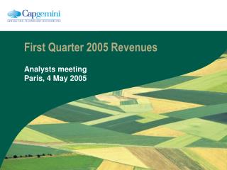
To see the animations, click on the “ Slide Show ” tab and select “From Beginning. Maps from First Quarter. Map 2 (No animations). The Diaspora. RUSSIA. LITHUANIA. Color land areas. LABEL COUNTRIES. Label Water areas. Label Cities (See next page.) Trace in RED the routes

E N D
To see the animations, click on the “Slide Show” tab and select “From Beginning Maps from First Quarter
Map 2 (No animations) The Diaspora
RUSSIA LITHUANIA Color land areas. LABEL COUNTRIES. Label Water areas. Label Cities (See next page.) Trace in RED the routes From Jerusalem and from Rome. (See next page.) BRITAIN POLAND GERMANY Atlantic Ocean FRANCE Black Sea SPAIN NORTH AFRICA Mediterranean Sea
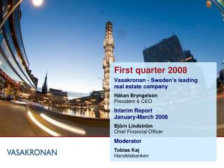
Map 3 The Empire of Charlemagne
Shade the Empire Controlled by Charlemagne In 814 (outlined in black) SAXONY Neustria Regions BAVARIA Austrasia BRITTANY Brittany Gascony Burgundy BURGUNDY Provence PROVENCE LOMBARDY Saxony GASCONY Austrasia Bavaria Lombardy Neustria
England IRELAND Ireland France ENGLAND Spain Aachen Pyrenees Mtns. Atlantic Ocean Paris ATLANTIC OCEAN Tours FRANCE Mediterranean Sea Poitiers Cities of: Rome Rome Paris Aachen SPAIN Poitiers MEDITERRANEAN SEA Tours
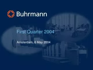
Map 4 Medieval Europe
Mediterranean Sea Black Sea Baltic Sea North Sea Atlantic Ocean SWEDEN Baltic Sea North Sea RUSSIA BRITAIN POLAND Bohemia MORAVIA (Kazakhstan) (Czech Republic) Atlantic Ocean FRANCE HUNGARY Bulgaria Hungary Bohemia Moravia Poland France Spain Britain Sweden Russia Modern-day Kazakhstan Black Sea BULGARIA SPAIN (Czech Republic) Mediterranean Sea
Novgorod SWEDEN Baltic Sea North Sea RUSSIA BRITAIN Novgorod Kiev Krakow Constantinople POLAND Kiev Krakow Bohemia MORAVIA (Kazakhstan) (Czech Republic) Atlantic Ocean FRANCE HUNGARY Black Sea BULGARIA SPAIN Constantinople Mediterranean Sea
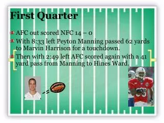
c. 600-1066 Anglo-Saxon Britain
NORTH SEA North Sea Irish Sea English Channel Wales Northumbria Jarrow Northumbria Mercia East Anglia Essex Sussex Wessex Kent Whitby York IRISH SEA Chester East Anglia Mercia WALES Jarrow Whitby York Chester Canterbury Essex Canterbury Sussex Kent Wessex ENGLISH CHANNEL
Map 5 The Viking World
Norway • Sweden • Denmark • England • Ireland • Iceland • Greenland • Newfoundland • Russia • Circle • Norway • Sweden • Denmark • Label them “Scandinavia” GREENLAND SCANDINAVIA ICELAND NORWAY SWEDEN RUSSIA DENMARK ENGLAND IRELAND NEWFOUNDLAND
North Sea Baltic Sea Black Sea Caspian Sea Atlantic Ocean Mediterranean Sea Italy Sicily France Spain GREENLAND ICELAND NORWAY SWEDEN RUSSIA North Sea Baltic Sea DENMARK Atlantic Ocean ENGLAND IRELAND NEWFOUNDLAND France Black Sea Caspian Sea Italy Spain Sicily Med Sea