Download

1 / 8
90 likes | 248 Views
Mt. Redoubt. By Nicole Kepron. World Map. In Southwestern Alaska Latitude: 60.485 ° N Longitude: 152.742° W Summit Elevation: 10,197 feet.

E N D
Mt. Redoubt By Nicole Kepron
World Map • In Southwestern Alaska • Latitude: 60.485° N • Longitude: 152.742° W • Summit Elevation: 10,197 feet
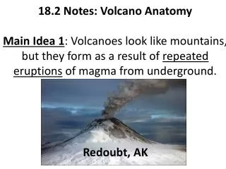
Plate tectonics cross-section showing how Redoubt is located above a subduction zone formed where the Pacific and North American plates collide. The Pacific Plate is melting to feed Redoubt's eruptions. Plate Boundaries Plate tectonics cross section • steep-sided stratovolcano • above the Aleutian subduction zone
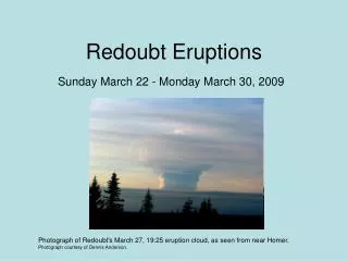
History Eruption Cloud • 1989-1990 • lahars, pyroclastic flows, and eruption columns • last eruption: 2009
Future • could erupt within days or weeks • seismic activity • several volcanic earthquakes occurring every hour • emergency kits ready
Impact • earthquakes • ash fall • lahars • evacuations
Facts • just erupted this year • born 890,000 years ago • ice-filled summit crater • threatens aircrafts and creates ash-related hazards
Bibliography • http://www.volcano.si.edu/world/volcano.cfm?vnum=1103-03- • http://latimesblogs.latimes.com/outposts/2009/01/alaskas-mount-r.html • http://www.msnbc.msn.com/id/28914322/ • http://www.mapme.com/nodes/view/38953-mount-redoubt-volcano • http://geology.com/usgs/redoubt-volcano-photos/signs-of-activity.shtml • http://geology.com/volcanoes/redoubt/