Download
1 / 18
180 likes | 298 Views
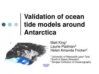
Validation of ocean tide models around Antarctica. Matt King , Nigel Penna, Peter Clarke, Ian Thomas University of Newcastle upon Tyne, United Kingdom. Above GRACE error budget. Introduction. Challenges of tide modelling in circum-Antarctic oceans Poor bathymetry/grounding line definitions

E N D
Validation of ocean tide models around Antarctica Matt King, Nigel Penna, Peter Clarke, Ian Thomas University of Newcastle upon Tyne, United Kingdom
Above GRACE error budget Introduction • Challenges of tide modelling in circum-Antarctic oceans • Poor bathymetry/grounding line definitions • Lack of data to assimilate (south of T/P cutoff) • Model physics developments required • Results in inaccurate and/or unvalidated models • The need for accurate ocean tide models • Altimetry –ICESat, ERS/EnviSat RA2 • GRACE • Mismodelled tidal signals alias • S2->162 days, K2->4 y with ~100% admittance • Sub-cm tidal prediction required RMS of gravity from ocean tide model differences (AG95, FES94.2) of M2, S2, K1, and O1 combined associated with harmonic degrees 1-50. From Knudsen et al. http://research.kms.dk/~pk/pubs/grace
Tidal characteristics (CATS02.01) Topex/Poseidon cutoff
Inter-model agreement (7 models) CATS02.01, CADA00.10, FES2004, CSR4, GOT00.2, NAO.99b, TPXO6.2
Tide Models to Validate • Global • TPXO6.2 – 0.25 x 0.25°; Assimilates T/P, TG • TPXO7.0 – 0.25 x 0.25°; Assimilates T/P + Jason, ERS (M2 & O1), TG • FES99 – 0.25 x 0.25°; T/P, TG • FES2004 – 0.125 x 0.125°; T/P, ERS • CSR4 – 0.5 x 0.5°; T/P • GOT00.2 - 0.5 x 0.5°; T/P, ERS • NAO.99b - 0.5 x 0.5°; T/P • Regional • MTOs.05 – 0.125 x 0.083° (south of 30°S); T/P • CATS02.01 – 0.25 x 0.083° (south of 58°S) • CADA00.10 - 0.25 x 0.083°; T/P; 37 TG, GPS and gravity sites
Relative accuracy assessment • Using onshore GPS and gravity data • Ocean tides periodically load Earth’s surface and it deforms (3d) • In Antarctica, this is up to ~80mm amplitude (shown) • Measurable by GPS (15 sites shown) and gravity (AMUN) • Fully independent measure of relative accuracy, over large spatial scales (hundreds of km) • Complements the use of TG data at discrete, but relatively few, points Maximum ocean tide loading displacement (mm), based on CATS02.01 + TPXO6.1
Ocean tide loading displacements • Daily GPS data analysed using GIPSY Precise Point Positioning (PPP) • Solid earth tide (IERS96), astronomical argument and mean nodal corrections applied • Daily site coordinates and other parameters (tropospheric zenith and gradient, clocks) estimated as normal • Ambiguity terms not fixed to integers • Daily estimates (and VCV) combined to produce final estimates of OTL displacement at each site • Model estimates • Tide Model + Green’s Functions using SPOTL software (D. Agnew) • CATS02.01/CADA00.10/MTOs.05 supplemented north of northern domains • Misfit statistic - sum of squares of complex misfits (S2)
Validation against VLBI • Compared (5-10y GPS data) against estimates from VLBI [Petrov & Ma, JGR, 2003] at 21 co-located sites • Fits with modelled values (TPXO6.2) similar in both Radial (shown) and North component • Fit with VLBI ~10-20% better in East component • GPS not good at K1 and K2 • VLBI not good at K1 (worse than GPS) • Very good agreement between GPS and model at N2, O1 (all components) Misfit - Radial Component
Antarctic Results All constituents No K1/K2 3d Radialonly Schenewerk et al. GPS Results
Fits at most sites on average <1mm2 per constituent for at least one model TPXO6.2, FES2004, CATS02.01, CADA00.10 fit best CSR4, NAO.99b not appropriate near large ice shelves Results
U E N GPS K1 and K2 biases Local N is 0° phase • Computed misfit with TPXO6.2 • Residuals as phasor plots • K1 • Approx. repeat period of GPS constellation • Misfits up to 5mm • No evidence for regional correlation in misfits • Multipath and/or orbit mismodelling+local effects
U E N K1 and K2 biases Local N is 0° phase • K2 • Orbital period of each satellite (approx.) • Misfits >2mm • North-East ~=90° • K2 estimates also drift in time • Suggestive of satellite-specific range bias • Satellite/block-specific phase centre offsets [e.g., Ge et al., GRL, 2005]
Gravity FES99 FES2004 TPXO7.0 CADA00.10 MTOs.05 TPXO6.2 South Pole gravity • No semi-diurnal/diurnal body tides • Relative gravity analysis of Knopoff et al. Units: uGal, same scale
South Pole gravity • No semi-diurnal/diurnal body tides • Relative gravity analysis of Knopoff et al. Units: uGal, same scale
Conclusions • GPS and VLBI have a similar capability to retrieve harmonic site displacements • TPXO6.2 presently the most accurate model for circum-Antarctic oceans (~5-7cm RMS for 4 constituents [King and Padman, GRL, 2005]) • CSR4 and NAO.99b are inaccurate near large ice shelves • FES2004 used in GRACE analysis; improvements could be found using TPXO6.2 around Antarctica • Further improvements in model accuracy • Better grounding-line and bathymetry (esp. under ice shelves) • Accurate data to assimilate with widespread geographical coverage (ice shelves) • GPS, IceSat, ERS/EnviSat • Theoretical developments in tide model physics