Download

1 / 41
410 likes | 562 Views
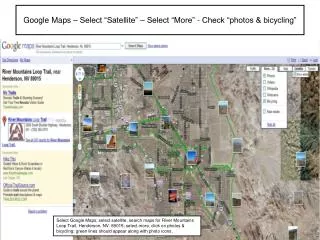
Something cool … http://maps.google.com. Google Maps API. Live earthquake mapping http://earthquakes.tafoni.net/ Other cool Google Maps API examples :. More Google …. Search full text of books e.g. http://books.google.com/books?q=uml Calculator Search tips & Hidden features

E N D
Google Maps API Live earthquake mapping http://earthquakes.tafoni.net/ Other cool Google Maps API examples:
More Google … • Search full text of bookse.g. http://books.google.com/books?q=uml • Calculator • Search tips & Hidden features • Also look for Google Code, Drive & Translate
MXD, Maps, Layers arcpy.mapping Classes
Without opening ArcMap, wouldn’t it be nice to • Get or update • MapDocument (MXD) properties • e.g. title, keywords, relative path, author, etc • DataFrame properties • e.g. name, coordinate system, etc. • Layer properties • e.g. name, visibility, data source, symbology, etc. • Layout element properties • e.g. size, position, • Add, remove, move, and update layers • Save MXD or LYR to earlier version for distribution • Build PDF map books • e.g. Export to PDF or insert into existing PDF
MapDocument – Class / Function … NOTE: Disable background processing when using “CURRENT”
Properties activeDataFrame (ro) activeView (rw) author (rw) credits (rw) dataDrivenPages (ro) dateExported (ro) datePrinted (ro) dateSaved (ro) description (rw) filePath (ro) hyperlinkBase (rw) relativePaths (rw) summary (rw) tags (rw) title (rw) Methods deleteThumbnail() findAndReplaceWorkspacePaths( find_workspace_path, replace_workspace_path, {validate}) makeThumbnail () replaceWorkspaces( old_workspace_path, old_workspace_type, new_workspace_path, new_workspace_type, {validate}) save () saveACopy( file_name, {version}) MapDocument Properties & Methods (ro) = read-only (rw) = read-write
Properties credits (rw) description (rw) displayUnits (rw) elementHeight (rw) elementPositionX (rw) elementPositionY (rw) elementWidth (rw) extent (rw) geographicTransformations (rw) mapUnits (ro) name (rw) referenceScale (rw) rotation (rw) scale (rw) spatialReference (rw) time (ro) type (ro) Methods panToExtent(extent) zoomToSelectedFeatures() DataFrame Properties & Methods
Find Layers in a DataFrame i.e. All layers in all DataFrame’s
Layer Class / Function Layer Class Layer Function
Properties brightness (rw) contrast (rw) credits (rw) datasetName (rw) dataSource (rw) definitionQuery (rw) description (rw) isFeatureLayer (ro) isGroupLayer (ro) isRasterizingLayer (ro) isRasterLayer (ro) labelClasses (rw) longName (ro) name (rw) serviceProperties (ro) showLabels (rw) transparency (rw) visible (rw) workspacePath (ro) Methods findAndReplaceWorkspacePath( find_workspace_path, replace_workspace_path, {validate}) getExtent( {symbolized_extent}) getSelectedExtent( {symbolized_extent}) replaceDataSource( workspace_path, workspace_type, dataset_name, {validate}) save () saveACopy( file_name, {version}) supports( layer_property) Layer Properties & Methods Layer = • .lyr file • Layer in DataFrame Selected properties
Working with Layers • arcpy.mapping can’t • Create new map layers in DataFrame or .lyr files from scratch • Change all layer properties in a script • arcpy.mapping can • Add lyr file to DataFrame & change selected layer properties • dataSource, definitionQuery, etc. (see “(rw)” on previous slide) • Apply symbology from existing lyr files to existing layers in DataFrame
Methods for fixing broken data sources MapDocument.findAndReplaceWorkspacePaths(find_workspace_path, replace_workspace_path, {validate}) MapDocument.replaceWorkspaces(old_workspace_path, old_workspace_type, new_workspace_path, new_workspace_type, {validate}) Layer.findAndReplaceWorkspacePath(find_workspace_path, replace_workspace_path, {validate}) Layer.replaceDataSource(workspace_path, workspace_type, dataset_name, {validate}) TableView.findAndReplaceWorkspacePath(find_workspace_path, replace_workspace_path, {validate}) TableView.replaceDataSource(workspace_path, workspace_type, dataset_name, {validate})
Fixing broken data source examples Update all workspace paths to new folder and save to new mxd. Update all workspace paths for all the mxd’s in a folder from local system to UNC paths
RefreshActiveView() and RefreshTOC() After changing the content of a DataFrame or Page Layout … arcpy.RefreshActiveView() After changing items in the Table of Contents (add, remove, move, update layers) …arcpy.RefreshTOC()
Working with arcpy.mapping scripts • Python Window has nice help … but pain for defining/calling functions, debugging, etc. • Edit in PyScripter and use Load …
Help is not perfect Should be: Find the MAPSURROUND_ELEMENT with the name "ScaleBar" and move it's x position (relative to its anchor point) to the center of the parentDataFrame. Save this change to the MXD. Update: ESRI listened to me:
MapDocument, DataFrame, Layer MapDocument MapDocument.ActiveView = “PAGE_LAYOUT” 1:* DataFrame DATAFRAME_ELEMENT MAPSURROUND_ELEMENT * GRAPHIC_ELEMENT Layer PICTURE_ELEMENT GRAPHIC_ELEMENT LEGEND_ELEMENT