Download
1 / 20
280 likes | 638 Views
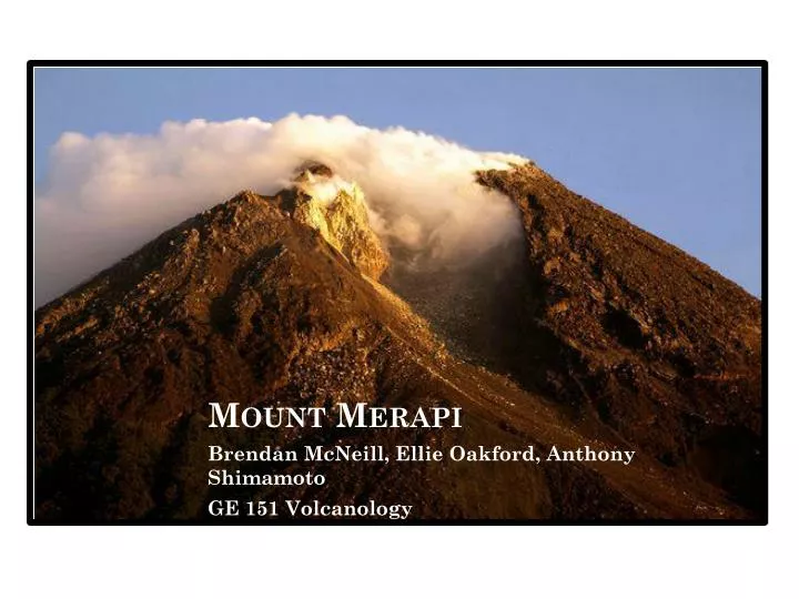
Mount Merapi. Brendan McNeill, Ellie Oakford , Anthony Shimamoto GE 151 Volcanology. Geography. Latitude: 7.5333° S Longitude: 110.4333° E Situated in South-Central Java 28 kilometers north of Yogyakarta. Tectonics.

E N D
Mount Merapi Brendan McNeill, Ellie Oakford, Anthony Shimamoto GE 151 Volcanology
Geography • Latitude: 7.5333° S • Longitude: 110.4333° E • Situated in South-Central Java • 28 kilometers north of Yogyakarta
Tectonics • Lies on the Sunda Volcanic arc, a chain of volcanoes that have formed from the northward subduction of the of the Indo-Australian Plate beneath the Eurasian Plate. • These are the same plates responsible for the giant 9.2 magnitude Indian ocean earthquake of 2004
The Sunda Arc • Is the volcanic arc formed along the islands of Sumatra and Java • Other major eruptions • Toba Super Eruption – approximately 74,000 years ago • Tambora 1815 • Krakatoa 1883
Specifics FORM DIMENSIONS • Typical stratovolcano, containing a summit crater with an unstable lava dome. • This results in the partial collapse of Merapi’s lava dome • Mount Merapi is approximately 2,930m (9,613ft) above sea level • The diameter of the Volcano is 400 meters across
Vents, Craters and Calderas • There are fumarolic areas surrounding the lava dome. • The crater of Mount Merapi is situated at the summit • Contains the lava dome which often collapses giving way to pyroclastic flows • There are no calderas at Merapi
Eruptive History • Recorded eruptions of Merapi have occurred in2010-11, 2007, 2006, 2001-02, 1992-98, 1972-90, 1971, 1967-69, 1961, 1953-58, 1948-49, 1944-45, 1942-43, 1939-40, 1933-35, 1930-31, 1924, 1923, 1922, 1920-21, 1918, 1915, 1909-13, 1908, 1906-07, 1905, 1902-04, 1902, 1897, 1894, 1893, 1891, 1889, 1888, 1885, 1883-84, 1878-79, 1872-73, 1872, 1869, 1865-67, 1862-64, 1854, 1849, 1848, 1846-47, 1846, 1840, 1837-38, 1832-35, 1828, 1822-23, 1820-22, 1812-13, 1810, 1807, 1797, 1786, 1755, 1752, 1745, 1678, 1677, 1672, 1663, 1658, 1587, 1584, 1560, 1554, 1548, 7630 BC. • Smaller eruptions occur in 2-5 year intervals • Larger eruptions occur in 10 year intervals • On average, every 100 years eruptions reach a VEI of 4
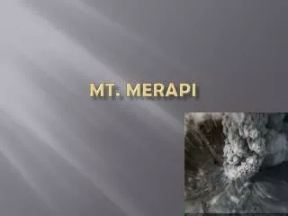
Observed Eruptions • Eruptions occur frequently at Merapi often causing minimal damage • The 2010 eruption caused significant damage and loss of life
Deposits in the 2010 eruption were significantly larger than any from the previous century.
Volcanic Hazards and Contributions • Merapi’s valleys that lead down to Yogyakarta have the potential to cause significant damage and flooding • The ability to mitigate the damage from lahars could be reduced significantly with the construction of dams • Indonesian government is unable to produce these dams due to lack of resources and infrastructure
Volcanic Deposits • Effusion primarily occurs at the lava dome • The form of deposits are commonly a result of, either fall out deposits or pyroclastic flows • Deposits have been primarily accumulated on the SW quadrant of the volcano where activity has been historically concentrated. • Given the varying range of eruptions that occur at Merapi, location and characteristics of deposits often depend upon the size of the Eruption
Petrology • Basaltic Andesite Lavas from Merapi contain 30-51 vol% Phenocrysts, and total crystalline contents are occasionally in excess of 70 vol%.
Hydrothermal Activity • Unique relationship between the hydrothermal system with rainfall and seismicity • When high rainfall occurs, there is a correlated drop in temperature and seismicity • Given the highly active and dangerous nature of Merapi, the hydrothermal deposits are not mined
Tourism • Yogyakarta’s is the second most popular tourist destination in Indonesia • Merapi is a popular hiking/trekking area for those who dare to get a close up of this highly active volcano
Geophysical Monitoring of Volcano • Due to its highly active nature and proximity to densely populated areas, the volcanic activity of Merapi is closely monitored • Designated as a Decade volcano
Monitoring Continued… • Merapi is assessed on a scale of 1-4 with 1 representing normal activity and 4 signifying that an eruption is imminent. • Today the use of tiltmeters, electronic distance measurements, seismometers, gas monitoring, satellite imagery and monitoring stations are utilized to keep track of Merapi’s activity.
Bibliography • Volcano Live http://www.volcanolive.com/merapi.html • University college London Volcano Group http://www.ucl.ac.uk/vco2/field-sites/Merapi • Volcanos Oregon State http://volcano.oregonstate.edu/vwdocs/volc_images/southeast_asia/merapi_hazard.html • The Smithsonian/NASA Astrophysics Data System http://adsabs.harvard.edu/abs/2011AGUFM.V43C2597N • he Behaviour of Base Metals in Arc-Type MagmaticHydrothermal Systems – Insights from Merapi Volcano http://www.geotop.ca/upload/files/publications/theses_doctorat/nadeau2011.pdf • The 2010 explosive eruption of Java's Merapi volcano – a ‘100- • year’ event http://hal-paris1.archives-ouvertes.fr/docs/00/72/34/12/PDF/Surono-JVGR-2012.pdf • Merapi (Central Java, Indonesia): An outline of the structural and magmatological evolution, with a special emphasis to the major pyroclastic events http://www.sciencedirect.com/science/article/pii/S0377027300001359 • Volcanic Lanforms http://faculty.weber.edu/bdattilo/shknbk/notes/vlcns.htm • GunungMerapi: Mountain of Fire http://gunungmerapi.weebly.com/index.html