Download
1 / 27
280 likes | 312 Views
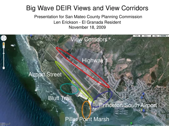
View Corridors. Highway 1. Airport Street. Bluff Trail. Princeton/South Airport. Big Wave DEIR Views and View Corridors Presentation for San Mateo County Planning Commission Len Erickson - El Granada Resident November 18, 2009. Pillar Point Marsh.

E N D
View Corridors Highway 1 Airport Street Bluff Trail Princeton/South Airport Big Wave DEIR Views and View Corridors Presentation for San Mateo County Planning CommissionLen Erickson - El Granada Resident November 18, 2009 Pillar Point Marsh
The Big Wave DEIR presents a total of five viewsto assess visual impact. Any site needs to be seen from a number of positions to assess visual impact. For a project as large as Big Wave, each DEIR view should be considered from a number of positions in an extended view corridor.
Story poles depict with accuracy the profile of a building from a number of view points.
In the absence of story poles, a structures position can be shown by inserting shaded areas or pictorial renderings with accurate perspective.
The larger the site, the more difficult it is to present accurate renderings without formal simulation software. • This report uses shaded areas of the type shown in the previous slide. • Each of five DEIR views were photographed from several positions in a corridor. At least two photographs are shown for each corridor in this report. • The visual impact for each DEIR view was rated as “Less than significant”. This report shows that when viewed with careful detail from multiple positions, there is significant impact on representative corridors that contain each of the five views. Analysis of DEIR Views
Photo emphasizing road and parking surface, not the vistas that attract the eye • Does not show view from heavily used trail to Mavericks / Pillar Point Beach • Does not show road view and parking lot view when entering the area Significant impact View 3: West Point AvenuePillar Point Marsh Corridor
Pillar Point Marsh:Trail near the shore linelooking toward Montara Mountain
Pillar Point Marsh:Trail near the shore linelooking toward Montara Mountain (Big Wave profile)
Pillar Point Marsh:Wellness Center from West Point Rd and Parking Lot
DEIR Photo minimizes vista that eye takes in - open airport and background mountains • Does not show transition views along highway 1 • DEIR photo mis-positions project. Significant impact View 5: Highway 1Highway 1 Corridor
Highway 1 - DEIR View 5:Near exit onto Capistrano toward harbor
Airport Hanger 28 Foot High Warehouse This view analysis shows that the project occupies the full angle between the airport hanger and warehouse. The DEIR photo showed a much smaller visual width for the project and actually positions it on an airport runway. Analysis of DEIR View 5
Big Wave DEIR View 5 Airport Street 28 Foot High Warehouse Airport Hanger BW EIR View 5
DEIR Photo emphasizing road and parking surface, not the vistas that attract the eye • DEIR photo does not show changing views while driving on Airport Street • DEIR does not show impact of buildings when viewing site directly in front of the building at street level. Significant impact View 1: Airport StreetAirport Street Corridor
Airport Street Corridor Across street from center of Office Park site
DEIR photo emphasizes road and parking surface, not the vistas that attract the eye • Does not show changing views while driving on streets leaving Princeton or at the airport south perimeter. Significant impact View 2: Airport Street / Stanford AvenuePrinceton / South Airport Corridor
Princeton / South Airport:Wellness Center / Storage Building /Part of Office Park Site from Cornell Avenue
Photo minimizes vista that eye takes in - open airport, mountains, harbor • Does not show transition of views along trail Significant impact View 4: North TrailBluff Trail Corridor
A preferred alternative to story polls for very large project is a true computer simulation which lets a person view alternatives configuration. • The DEIR is essentially using cut and paste of site renditions, leading to the problems documented at View 3. • Simulations allow moving views • Simulations make it possible to accurately assess alternatives. • For example - What if Wellness and Office Park were on the north site? • As another important factor, only a true simulation can let a viewer experience the effect of light emission from the site at dusk and night. Alternate Methods
The Big Wave project site is visible throughout all key travel (car and foot) corridors in the largest flat land open space on the Midcoast. • There is a significant impact of the project on project views, requiring both more accurate study and evaluation for alternate site configurations. • This analysis presented in this report provides a broader review than the DEIR with respect to whether it has a demonstrable negative negative aesthetic effect on the public view space. • This analysis shows that the Big Wave will substantially degrade the existing visual character of the airport /agricultural plain. • For decision makers and the the public to make an informed review of the project's effect on existing views and vistas additional documentation and analysis with better tools (story polls and true computer simulations) is required. In Conclusion…