Download

1 / 47
470 likes | 679 Views
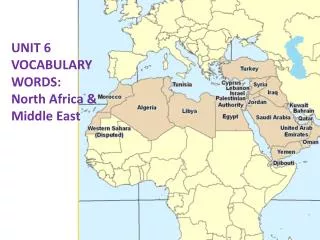
Physical Geography of N. Africa, SW Asia, & Central Asia. How does the region of North Africa, Southwest Asia, and Central Asia compare to the size of the United States? - twice the size of the U.S. .

E N D
Physical Geography of N. Africa, SW Asia, & Central Asia
How does the region of North Africa, Southwest Asia, and Central Asia compare to the size of the United States? -twice the size of the U.S.
What 3 major peninsulas are found in the Middle East (SW Asia) & North Africa? List the bodies of water that surround each. 1. Anatolia -bordered by Black Sea, Mediterranean Sea, and Aegean Sea -makes up 90% of country of Turkey
2. Arabian Peninsula- -bordered by Red Sea, Arabian Sea, and Persian Gulf -oil-rich region (about 25% of the world’s oil lies underneath)
3. Sinai Peninsula- • bordered by Gulf of Suez, Gulf of Aqaba, and Mediterranean Sea • currently Egyptian territory (was also part of Israel historically)
Dead Sea Israel Nile Delta Gulf of Suez Gulf of Aqaba Saudi Arabia Egypt Red Sea
3. Name the 3 landlocked bodies of salt water located in this region. • Dead Sea • Is the Dead Sea really a sea? • What does the Dead Sea separate? • What is it’s source? • What 3 things make it so unique? • Why is the Dead Sea so salty? How does it impact life in and around it? • What religious association do Christians have with the Dead Sea? Jordan River Israel
2. Aral Sea • began to dry up due to irrigation from the Soviet Union & evaporation, now being replenished
3. Caspian Sea • largest inland body of water • not as salty as ocean – includes some freshwater fish • currently, water levels are lowering due to evaporation & irrigation (much like the case of the shrinking Aral Sea, just not as extreme)
4. What sea separates North Africa from Europe? What is its significance to this region? • The Mediterranean Sea • Links Europe & Africa to the east
5. What sea separates the Middle East (Southwest Asia) from North Africa? • The Red Sea
6. What 2 straits separate Europe from Southwest Asia (Middle East)? What sea links the two? 1. The Bosporus- • Strait connecting the Sea of Marmara to the Black Sea; 2. The Dardanelles- • Strait connecting the Sea of Marmara to the Aegean Sea
7. What strait separates the closest pieces of land of North Africa and Europe? • Strait of Gibraltar- • Choke-point connecting Mediterranean Sea to the Atlantic Ocean
Europe Mediterranean Sea Atlantic Ocean North Africa
8. What man-made waterway connects the Mediterranean Sea with the Red Sea? • The Suez Canal • When was it built? • 1858-1869 • Who built it? • Mostly French-financed and designed using Egyptian forced labor • Significance = connect Mediterranean to the greater Indian Ocean for trade
Nile Delta Sinai Peninsula Red Sea
9. What major rivers flow through the Middle East (Southwest Asia) & North Africa? 1. The Tigris- 2. The Euphrates- • Both rivers flow out of Turkey through Iraq and come together before flowing into Persian Gulf; • Mesopotomia (early river valley civilization) located between the rivers (literally means “land between two rivers”)
3. The Nile River -world’s longest river at 4,160 miles -supported the early Egyptian civilization *alluvial soil (rich soil made up of sand and mud deposited by moving water) allowed Egyptians the ability to farm
10. What man-made lake was created by damming the Nile River? • Lake Nasser • Began in 1958; completed in 1970, when Aswan High Dam was finished; • 80% in Egypt Aswan High Dam
Aswan High Dam -pros: supplies ½ of Egypt’s electric power & water to crops -cons: sediments from river get trapped behind dam & floods no longer wash away parasites Aswan High Dam Air Strip
11. Why is the Nile River Delta so important? • 90% of people of Egypt live along banks of (only fertile areas in Egypt) • Pollution a serious problem.
12. Name the only major mountain range in North Africa. How does its physical presence impact the people that live in areas surrounding the mountain? • The Atlas Mountains • Precipitation on coastal (N) side – agricultural activities • named after Greek god who held up the heavens.
13. What mountain range separates the countries of Iran and Iraq? • The Zagros Mountains
14.Which tectonic plates come together in this region? List 3 ways the region’s landscape has been impacted by plate tectonic activity. -African, Arabian, and Eurasian plates -built Zagros and Taurus Mountains & widened the Red Sea
15.What % of world’s know oil & natural gas reserves are found in this region? -66% oil reserves & 33% natural gas reserves -see Black Gold activity for more information
What physical reason do you believe makes this region so economically dependent on oil and natural gas? -harsh terrain (mountainous & desert) leaves little hope for agriculture