Download
1 / 4
40 likes | 232 Views
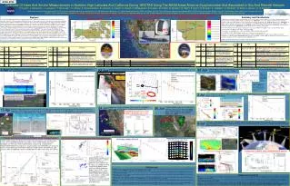
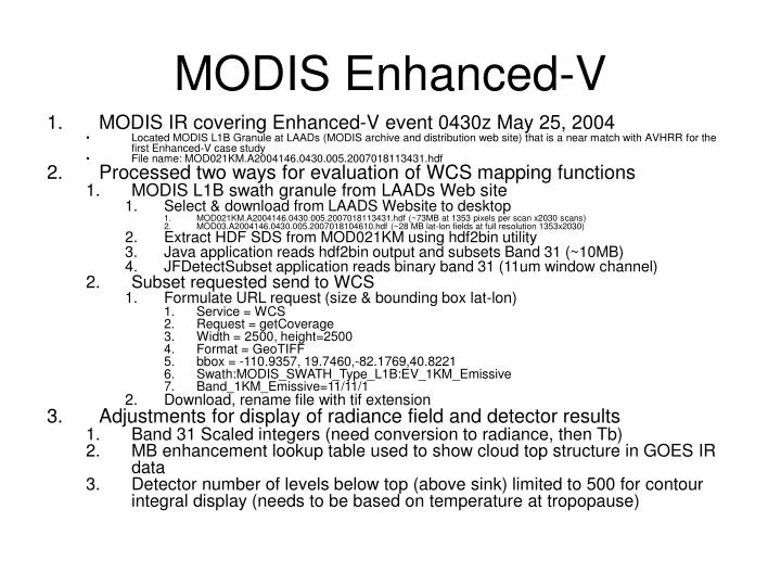
MODIS Enhanced-V. MODIS IR covering Enhanced-V event 0430z May 25, 2004 Located MODIS L1B Granule at LAADs (MODIS archive and distribution web site) that is a near match with AVHRR for the first Enhanced-V case study File name: MOD021KM.A2004146.0430.005.2007018113431.hdf

E N D
MODIS Enhanced-V • MODIS IR covering Enhanced-V event 0430z May 25, 2004 • Located MODIS L1B Granule at LAADs (MODIS archive and distribution web site) that is a near match with AVHRR for the first Enhanced-V case study • File name: MOD021KM.A2004146.0430.005.2007018113431.hdf • Processed two ways for evaluation of WCS mapping functions • MODIS L1B swath granule from LAADs Web site • Select & download from LAADS Website to desktop • MOD021KM.A2004146.0430.005.2007018113431.hdf (~73MB at 1353 pixels per scan x2030 scans) • MOD03.A2004146.0430.005.2007018104610.hdf (~28 MB lat-lon fields at full resolution 1353x2030) • Extract HDF SDS from MOD021KM using hdf2bin utility • Java application reads hdf2bin output and subsets Band 31 (~10MB) • JFDetectSubset application reads binary band 31 (11um window channel) • Subset requested send to WCS • Formulate URL request (size & bounding box lat-lon) • Service = WCS • Request = getCoverage • Width = 2500, height=2500 • Format = GeoTIFF • bbox = -110.9357, 19.7460,-82.1769,40.8221 • Swath:MODIS_SWATH_Type_L1B:EV_1KM_Emissive • Band_1KM_Emissive=11/11/1 • Download, rename file with tif extension • Adjustments for display of radiance field and detector results • Band 31 Scaled integers (need conversion to radiance, then Tb) • MB enhancement lookup table used to show cloud top structure in GOES IR data • Detector number of levels below top (above sink) limited to 500 for contour integral display (needs to be based on temperature at tropopause)
MOD021KM.A2004146.0430.005.2007018113431.hdf • Select & download from LAADS Website to desktop • Subset to binary using hdf2bin utility • URL request to WCS for subset on lat-lon grid • Downloaded from WCS to desktop Swath 1354x2030 Lat Lon 2500x2500
Lat-Lon subset Grid 30x30 Swath subset Grid 30x30 • Detected Peaks (tops) • Contour maximum (cloud top) • Orange – single level • Red – multiple levels • Contour Integral max & min • Drawn from • Blue – modes (max) • Green – nodes (min) • Detected Sinks (holes) • Contour minimum (sink) • Orange – single level • Red – multiple levels • Contour Integral max & min • Blue – modes • Green - nodes