Download
1 / 47
490 likes | 677 Views
Vicarious Calibration Using Earth Targets. Xiangqian (Fred) Wu Sensor Physics Branch Satellite Meteorology and Climatology Division Center for Satellite Applications and Research (STAR, formally ORA) National Environmental Satellite, Data, and Information Service (NESDIS)

E N D
Vicarious Calibration Using Earth Targets Xiangqian (Fred) Wu Sensor Physics Branch Satellite Meteorology and Climatology Division Center for Satellite Applications and Research (STAR, formally ORA) National Environmental Satellite, Data, and Information Service (NESDIS) National Oceanic and Atmospheric Administration (NOAA) With help from many colleagues Achieving Satellite Instrument Calibration for Climate Change, May 17, 2006, Lansdowne, VA
Vicarious Calibration Using Earth Targets Outline of the assignments: • Overview of the technique • Relation to ASIC3 • Present and planned capabilities • Impediments to progress • Recommendations Achieving Satellite Instrument Calibration for Climate Change, May 17, 2006, Lansdowne, VA
Vicarious Calibration Using Earth Targets Context Outline of the assignments: • Overview of the technique • Relation to ASIC3 • Necessary conditions for ASIC3 • Common practices • Present and planned capabilities • Impediments to progress • Recommendations Achieving Satellite Instrument Calibration for Climate Change, May 17, 2006, Lansdowne, VA
Vicarious Calibration Using Earth Targets Context Some Necessary Conditions for ASIC3: • Pre-launch • Sensor be fully characterized • Post-launch Sensor performance be • Continuously monitored • Independently validated • Deficiency/Anomaly be identified, resolved, documented, and feedback for • re-analysis of historical data • development of future sensors Achieving Satellite Instrument Calibration for Climate Change, May 17, 2006, Lansdowne, VA
Vicarious Calibration Using Earth Targets Context Some common avenues to ASIC3 (Integrated Cal/Val System): • Verification of internal consistency of onboard calibration • Cross calibration with reference radiances • Dedicated sensor for on-orbit reference • Terrestrial Targets • Celestial targets: Moon, Star • Cross calibration with measured radiances • Among any sensors, e.g., POES vs. GOES, operational vs. research • Same S/C (temporal, geometric), e.g., imager vs. sounder • Same series (spectral, spatial), e.g., POES vs. POES • SNO • Cross calibration with simulated radiances • NWP and CRTM • Monitoring, archiving, and disseminating the results in near real time throughout the sensor's mission life. Weng Achieving Satellite Instrument Calibration for Climate Change, May 17, 2006, Lansdowne, VA
Vicarious Calibration Using Earth Targets Overview Outline of the assignments: • Overview of the technique • Definition and Scope • Instrumented and non-instrumented targets • Four types of stable earth targets • Relation to ASIC3 • Present and planned capabilities • Impediments to progress • Recommendations Achieving Satellite Instrument Calibration for Climate Change, May 17, 2006, Lansdowne, VA
Vicarious Calibration Using Earth Targets Overview • Calibration • The extraction of signal from sensor’s measurements … • … by means of reference signal • Vicarious Calibration • the reference is external to the sensor Measurement At-aperture radiance Artifact Calibration signal Achieving Satellite Instrument Calibration for Climate Change, May 17, 2006, Lansdowne, VA
Vicarious Calibration Using Earth Targets Overview • Calibration • The extraction of signal from sensor’s measurements … • … by means of reference signal • Vicarious Calibration • the reference is external to the sensor • Scope of the discussion • Limited to radiometric calibration • Focused on VISNIR (METEOSAT also used it for IR) • Stable earth targets Achieving Satellite Instrument Calibration for Climate Change, May 17, 2006, Lansdowne, VA
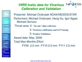
Vicarious Calibration Using Earth Targets Overview • Instrumented Earth Targets • Lake Tahoe, Qinghai Lake: IR imaging instruments Hook Zhang et al Achieving Satellite Instrument Calibration for Climate Change, May 17, 2006, Lansdowne, VA
Vicarious Calibration Using Earth Targets Overview • Instrumented Earth Targets • Lake Tahoe, Qinghai Lake: IR imaging instruments • Railroad Valley (playa), Dunhuang (desert): VISNIR Zhang et al Thome Achieving Satellite Instrument Calibration for Climate Change, May 17, 2006, Lansdowne, VA
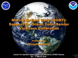
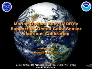
Vicarious Calibration Using Earth Targets Overview • Instrumented Earth Targets • Lake Tahoe, Qinghai Lake: IR imaging instruments • Railroad Valley (playa), Dunhuang (desert): VISNIR • MOBY: ocean color NOAA/NESDIS/ORA Achieving Satellite Instrument Calibration for Climate Change, May 17, 2006, Lansdowne, VA
Vicarious Calibration Using Earth Targets Overview • Instrumented Earth Targets • Lake Tahoe, Qinghai Lake: IR imaging instruments • Railroad Valley (playa), Dunhuang (desert): VISNIR • MOBY: ocean color • ARM Sites (SGP CART in particular): IR/MW sounding instruments Achieving Satellite Instrument Calibration for Climate Change, May 17, 2006, Lansdowne, VA
Vicarious Calibration Using Earth Targets Overview • Instrumented Earth Targets • Lake Tahoe, Qinghai Lake: IR imaging instruments • Railroad Valley (playa), Dunhuang (desert): VISNIR • MOBY: ocean color • ARM Sites (SGP CART in particular): IR/MW sounding instruments • Cal/Val Campaign with aircraft/ship Scripps CIMSS Achieving Satellite Instrument Calibration for Climate Change, May 17, 2006, Lansdowne, VA
Vicarious Calibration Using Earth Targets Overview • Instrumented Earth Targets • Lake Tahoe, Qinghai Lake: IR imaging instruments • Railroad Valley (playa), Dunhuang (desert): VISNIR • MOBY: ocean color • ARM Sites (SGP CART in particular): IR/MW sounding instruments • Cal/Val Campaign with aircraft/ship • Stable Earth Targets • Scene Statistics • Scattering & Reflection • Ice Sheet (Greenland, Antarctica) • Desert (North Africa, Australia) Achieving Satellite Instrument Calibration for Climate Change, May 17, 2006, Lansdowne, VA
Vicarious Calibration Using Earth Targets Overview • Scene Statistics • Representative works • Brest and Rossow (1992) • Tokunu and Itaya (1994) • Crosby et al (2005) • Reference • Selected scenes, global or regional, all or clouds • Assumptions • Statistical characteristics of the selected scenes are invariant in time Achieving Satellite Instrument Calibration for Climate Change, May 17, 2006, Lansdowne, VA
Vicarious Calibration Using Earth Targets Overview • Scene Statistics Crosby et al 2005 Achieving Satellite Instrument Calibration for Climate Change, May 17, 2006, Lansdowne, VA
Vicarious Calibration Using Earth Targets Overview • Scene Statistics • Easy to implement • No scene selection such as cloud/clear • Fundamental flaw in assuming that certain earth scenes are statistically invariant in time • Cannot detect climate change • Often violated in shorter time scale • Relative calibration only Achieving Satellite Instrument Calibration for Climate Change, May 17, 2006, Lansdowne, VA
Vicarious Calibration Using Earth Targets Overview • Scattering and Reflection • Representative works • Fraser and Kaufman (1986) • Kaufman and Holben (1993) • Vermote and Kaufman (1995) • Reference • Molecular scattering and reflection from sun glint or cloud • Assumptions • F&K: VIS measurements at certain angle is dominated by molecular scattering, which is invariant in time and space • K&H: Reflection from sun glint is spectrally invariant • V&K: • Spectral difference of aerosol scattering is known • Reflection from cloud top is spectrally invariant Achieving Satellite Instrument Calibration for Climate Change, May 17, 2006, Lansdowne, VA
Vicarious Calibration Using Earth Targets Overview • Scattering and Reflection Achieving Satellite Instrument Calibration for Climate Change, May 17, 2006, Lansdowne, VA
Vicarious Calibration Using Earth Targets Overview • Scattering and Reflection • Abundant targets • Potential to have very large sample size • Absolute calibration (subject to uncertainty) • Rely on model • Uncertainty in model input • Sensitivity of model to input uncertainty • Molecular scattering signal is weak (~4%) Achieving Satellite Instrument Calibration for Climate Change, May 17, 2006, Lansdowne, VA
Vicarious Calibration Using Earth Targets Overview • Ice Sheet • Representative works • Loeb 1997 • Tahnk and Coakley (2001) • Reference • Reflection from ice sheet over Greenland and Antarctica • Assumptions • TOA reflectance is a quadratic function of solar zenith angle Achieving Satellite Instrument Calibration for Climate Change, May 17, 2006, Lansdowne, VA
Vicarious Calibration Using Earth Targets Overview • Ice Sheet Antarctica Greenland Channel 1 Channel 2 Achieving Satellite Instrument Calibration for Climate Change, May 17, 2006, Lansdowne, VA
Vicarious Calibration Using Earth Targets Overview • Ice Sheet • Strong signal (~1/3 of dynamic range) • Correction involves solar zenith angle • Advantage in the presence of orbit drift • Relative calibration • Difficulty in cloud detection (VIS or IR) • Targets distribution – a lot of targets for a short period of time Achieving Satellite Instrument Calibration for Climate Change, May 17, 2006, Lansdowne, VA
Vicarious Calibration Using Earth Targets Overview • Desert • Representative works • Staylor (1990) • Rao and Chen (1996, 1999) • Reference • Reflection from selected desert sites • Assumptions • Surface characteristics is stable • TOA reflectance is well understood Achieving Satellite Instrument Calibration for Climate Change, May 17, 2006, Lansdowne, VA
Vicarious Calibration Using Earth Targets Overview • Desert From “Desert” by Christoph Heidelauf Achieving Satellite Instrument Calibration for Climate Change, May 17, 2006, Lansdowne, VA
Vicarious Calibration Using Earth Targets Overview • Desert • Strong signal • Variety of signal • Different desert • Relative calibration • Noise (H2O, dust/aerosol, O3) Achieving Satellite Instrument Calibration for Climate Change, May 17, 2006, Lansdowne, VA
Vicarious Calibration Using Earth Targets Capabilities Outline of the assignments: • Overview of the technique • Relation to ASIC3 • Present and planned capabilities • Operational calibration at NOAA/NESDIS • Requirements for climate may differ from those for operations • Impediments to progress • Recommendations Achieving Satellite Instrument Calibration for Climate Change, May 17, 2006, Lansdowne, VA
Vicarious Calibration Using Earth Targets Capabilities Since 1996 • Monthly update of AVHRR solar bands calibration coefficients • Second Tuesday every month • Disseminate the product • Level 1B data stream • Direct user notification • Web (planned improvement) • All actions archived Achieving Satellite Instrument Calibration for Climate Change, May 17, 2006, Lansdowne, VA
Vicarious Calibration Using Earth Targets Capabilities Recent Improvements • Product monitoring • Sinusoidal Function • More checks for non-target pixels (cloud, precipitation, dust) • Target homogeneity • Precision • Current 5-10% • Planned 3-5% Achieving Satellite Instrument Calibration for Climate Change, May 17, 2006, Lansdowne, VA
Vicarious Calibration Using Earth Targets Capabilities Product Monitoring & Precision N16 – N17 AVHRR during SNO: Mean ~40%; Difference < 2% Achieving Satellite Instrument Calibration for Climate Change, May 17, 2006, Lansdowne, VA
Vicarious Calibration Using Earth Targets Capabilities Product Monitoring & Precision • Standard Deviation Achieving Satellite Instrument Calibration for Climate Change, May 17, 2006, Lansdowne, VA
Vicarious Calibration Using Earth Targets Capabilities Recent Improvements • Product monitoring • Sinusoidal Function • More checks for non-target pixels (cloud, precipitation, dust) • Target homogeneity • Precision • Current 5-10% • Planned 3-5% • Accuracy: Uncertain • Earlier (Aircraft via NOAA-9): 37.8% for Channel 1 • Lately (MODIS, supported by ATSR and MISR): ~41% • Reconcile the difference • Impact on users Achieving Satellite Instrument Calibration for Climate Change, May 17, 2006, Lansdowne, VA
Vicarious Calibration Using Earth Targets Capabilities Planned for near future • Account for water vapor variation Refl=α+βt+A*cos(ωt+φ0) Heidinger Achieving Satellite Instrument Calibration for Climate Change, May 17, 2006, Lansdowne, VA
Vicarious Calibration Using Earth Targets Capabilities Planned for near future • Account for water vapor variation • Other model of target BRDF Refl=α+βt+A*cos(ωt+φ0) cosρ=cosθcosθ0+ sinθsinθ0cos(azm) θ≈0→ cosρ≈cosθ0 Stable orbit → θ0~t • Are θ and θ0 reciprocal? • Is Refl linear function of cosρ? • Account for orbit drift (METEOSAT)? Achieving Satellite Instrument Calibration for Climate Change, May 17, 2006, Lansdowne, VA
Vicarious Calibration Using Earth Targets Impediments Outline of the assignments: • Overview of the technique • Relation to ASIC3 • Present and planned capabilities • Impediments to progress • Target characterization • Reference value • Diurnal/Annual variation • Atmospheric effect (water vapor, aerosol, O3) • Sensor characterization • Multiple good targets • Recommendations Achieving Satellite Instrument Calibration for Climate Change, May 17, 2006, Lansdowne, VA
Vicarious Calibration Using Earth Targets Impediments Achieving Satellite Instrument Calibration for Climate Change, May 17, 2006, Lansdowne, VA
Vicarious Calibration Using Earth Targets Impediments Achieving Satellite Instrument Calibration for Climate Change, May 17, 2006, Lansdowne, VA
Vicarious Calibration Using Earth Targets Impediments • Sensor Characterization • Spectral Response Function • Inadequately specified • Many unknowns • Effort to archive all online … • … and quantify their uncertainty • Radiometric Calibration • Pre-launch calibration procedure Achieving Satellite Instrument Calibration for Climate Change, May 17, 2006, Lansdowne, VA
Vicarious Calibration Using Earth Targets Impediments Perfect target generates the same signal … • At different time • On synoptic (“weather”), seasonal (vegetation), and inter-annual (El Niño) scales • High altitude (less water vapor and dust variation) • From different parts • Sensor’s IFOV, navigation error, cloud detection • In different spectral band • Difference/Uncertainty in SRF of sensors • To different directions (sun/sensor geometry) • Flat • Low latitude • Near the upper limit of sensor’s dynamic range • To increase S/N ratio and • To reduce uncertainty when extrapolated • Not contaminated (by clouds) • More for GEO Achieving Satellite Instrument Calibration for Climate Change, May 17, 2006, Lansdowne, VA
Vicarious Calibration Using Earth Targets Recommendations Outline of the assignments: • Overview of the technique • Relation to asic3 • Present and planned capabilities • Impediments to progress • Recommendations Achieving Satellite Instrument Calibration for Climate Change, May 17, 2006, Lansdowne, VA
Vicarious Calibration Using Earth Targets Recommendations • Continue the effort in vicarious calibration using stable earth targets • No other way to measure and calibrate the climate in the past • Collaboration • International (sites, sensors, creativity) • GEO and LEO • Research and operation • Producer and user. Find a good application. • NDVI • Aerosol • Cryosphere • Radiation budget • Learn the lesson • Channel alignment (GOES-R ABI with VIIRS) • Better specifications • Operation overlap Achieving Satellite Instrument Calibration for Climate Change, May 17, 2006, Lansdowne, VA
Backup Achieving Satellite Instrument Calibration for Climate Change, May 17, 2006, Lansdowne, VA
Backup • Some were modified to be aligned with VIIRS • Some differences remain Achieving Satellite Instrument Calibration for Climate Change, May 17, 2006, Lansdowne, VA
Backup Achieving Satellite Instrument Calibration for Climate Change, May 17, 2006, Lansdowne, VA
Backup Achieving Satellite Instrument Calibration for Climate Change, May 17, 2006, Lansdowne, VA
Backup Achieving Satellite Instrument Calibration for Climate Change, May 17, 2006, Lansdowne, VA
Backup Achieving Satellite Instrument Calibration for Climate Change, May 17, 2006, Lansdowne, VA