Download
1 / 24
240 likes | 387 Views
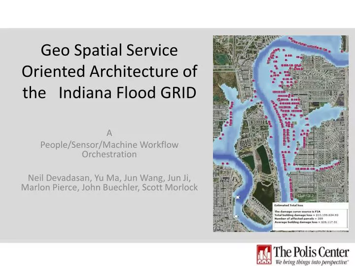
Geo Spatial Service Oriented Architecture of the Indiana Flood GRID. A People/Sensor/Machine Workflow Orchestration Neil Devadasan, Yu Ma, Jun Wang, Jun Ji , Marlon Pierce, John Buechler , Scott Morlock. Collaborative effort. City of Indianapolis Indianapolis Museum of ART INDHS USACE

E N D
Geo Spatial Service Oriented Architecture of the Indiana Flood GRID A People/Sensor/Machine Workflow Orchestration Neil Devadasan, Yu Ma, Jun Wang, Jun Ji, Marlon Pierce, John Buechler, Scott Morlock
Collaborative effort • City of Indianapolis • Indianapolis Museum of ART • INDHS • USACE • IDNR • NWS • USGS • Polis, IUPUI • Community GRID Lab, IU • Silver Jackets
Silver Jackets • Collaborative Team of Agencies • State • Federal • Regional MANY AGENCIES – ONE SOLUTION
Background the Pilot Research Project • Our pilot study area is Ravenswood • Ravenswood floods very frequently • Indianapolis Museum of Arts “Nature Park” get flooded too and had an interest in modeling this area • USGS water scientist had modeled this area with high resolution DEM’s • The Polis Center had experience in Hazus-MH pre disaster mitigation planning tools (Prepared plans for IN/IL/WI for more than 100 counties) • USGS Water Sciences Division and The Polis Center Partnership
Objective • Generate current and forecast flood inundation maps: USGS and NWS data, 2D Hydraulic model (FastMECH) • Generate flood maps for HAZUS-MH Analysis • Serve flood maps (near-real-time) through Web
Opportunity • USGS Cap 2 Geospatial SOA Best Practices grant • Windowed Apps to Windowless Processes • Research + Opportunity > Innovation
Distributed Processes and Asynchronous I/O Parcel Assessment & Hazus Data Service (Polis) CGNS Data Property Assessment Data Model Design & Calibration (USGS Water Scientists) Loss Estimate Reports Flood Depth Grid Data Water Flow Data Flood Map Loss Calculation Process (Polis) Demographics FastMech Process (IU Big Red) SAVI (Polis) Parcel Map Real-Time Water Flow Gauge Data (USGS) Maps Parcel Boundaries (Marion County)
Heterogeneous • Operating Systems • Compilers • Communication Protocols • Development Frameworks • Data bases and File Systems
Summary • The partnerships cultivated during the original Pilot Study are KEY to the success of this project • Government agencies and all other partners have a vested interest in this project • We are using our partnerships to • Leverage financial resources • Expand research in computing • Expand technical expertise • Innovative ways of using geospatial SOA • Integrates with widely used AHPS (Advanced Hydrologic Prediction System) • Depth/Extent information + HAZUS analysis + response plans • Allows for protection of life and property before water reaches critical levels
Special Thanks to USGS Water Scientists • Scott Morlock (smorlock@usgs.gov) • Moon Kim (mkim@usgs.gov) • Leslie Arihood (larihood@usgs.gov) • James Kiesler (jkiesler@usgs.gov)
Demo • http://134.68.246.114/FloodLossEstimatorWS/FILA/FILAUI.html • Floodgrid-auto.swf
Identify best practices that resulted from this work that are relevant in the federal/intergovernmental environment This work resulted in an application that has integrated existing flood data streams from the National Weather Service and U.S. Geological Survey to create a real-time and forecast flood inundation tool. The tool allows Federal, State, and local emergency managers to make flood planning, response, and mitigation decisions to safeguard life and property. The tool displays both real-time and forecast flood depths and extents on a street-level map. The tool can be used to identify flooded parcels and create real-time flood damage loss estimates. The SOA architecture used by the tool allows flood data from independent agencies and operating systems to be seamlessly combined to create flood maps and reports for the user. The best practice of most relevance is that existing data streams and sources have been combined to create a visual flood response and mitigation tool for the 21st century.
What is the level of maturity and viability of the referenced SOA/Cloud solutions or infrastructure within a governmental computing environment? This solution has the highest level of viability as it builds existing multi-agency services into a single application for flood planning, response, and mitigation. This tool is highly expandable on State, Regional, and even National Basis. This is because the base data streams NWS flood forecasts and USGS streamgage data are widespread and uniform in data distribution, and because the need for real-time and flood forecast maps is universal for flood prone communities. The level of maturity of the real-time flood application is new this is a cutting edge and new application; however, the maturities of the services that are integrated by the tool are very high.
What are perceived impediments to adoption of your highlighted SOA/cloud practices in the government environment? Funding resources may be limited, as their is currently not an identified long-term source of operations and maintenance funds. For the foreseeable future there are resources to keep the pilot river reach application running, but expansion of the effort will require sources of funding for further development, refinement, and maintenance
Questions? • Contact Information • Neil Devadasan (ndevadas@iupui.edu) • Marlon Pierce (mpierce@cs.indiana.edu)