Download
1 / 34
350 likes | 591 Views
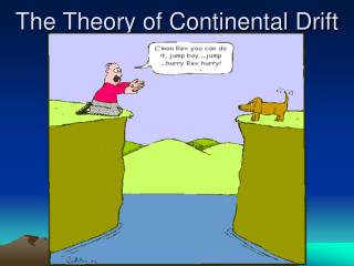
Today’s Lecture: Chaps. 3 & 4 Continental Drift & Seafloor Spreading. In Lecture Today:. Alfred Wegener and the hypothesis of continental drift. Evidence supporting continental drift. Hypothesis of polar wandering. Discoveries leading up to the hypothesis seafloor spreading.

E N D
Today’s Lecture: Chaps. 3 & 4 Continental Drift & Seafloor Spreading
In Lecture Today: • Alfred Wegener and the hypothesis of continental drift. • Evidence supporting continental drift. • Hypothesis of polar wandering. • Discoveries leading up to the hypothesis seafloor spreading. • Major features of the seafloor. • Rock magnetism - a review. • Tests of the seafloor spreading hypothesis.
He hypothesized: existence of single “super-continent” Pangaea (“pan - G - uh”) ~ 200 million years ago Pangaea broke into smaller pieces, which “drifted” to their present positions Continental Drift Historical Development 1915 Alfred Wegener published his hypothesis of continental drift
LAURASIA GONDWANALAND 200 million years ago P A N G A E A
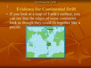
CONTINENTAL DRIFT Historical development Evidence from rocks: Mountain belts on one continent match up to the rocks found on another continent. Example: Rocks of similar age & structure are found in the: Appalachians (eastern US) British Isles, Scandanavia
CONTINENTAL DRIFT Historical development Paleoclimate evidence Gondwanaland glacial deposits are today scattered around on different continents…
CONTINENTAL DRIFT Historical development Paleoclimate evidence (ancient) …but when Pangea is reassembled, these glacial deposits all match up perfectly!
CONTINENTAL DRIFT Historical development Fossil Evidence Distributions of many fossil species found on different continents only make sense in light of continental drift Mesosaurus How can the same species evolve on widely separated continents??? Lystrosaurus
CONTINENTAL DRIFT Historical development 1924 Alfred Wegener’s book translated to English, and was greeted with (to put it politely) hostile criticism! Main objections: There was no clear drift mechanism and thus, no way to explain how continents could “plow” their way through the seafloor. The seafloor was believed to be static, fixed and very old. Radiometric dating was not developed until the 1950’s. Most of our knowledge of the seafloor was based on original surveys by the HMS Challenger global expedition carried out during the 1850’s.
CONTINENTAL DRIFT Historical Development Alfred Wegener’s continental drift idea died until 1950’s, when the field of military oceanography began to mature. New discoveries on the seafloor lead to the hypothesis of seafloor spreading proposed by American scientists, Hess and Dietz. During the 1970’s, the hypothesis of seafloor spreading was tested using discoveries in the field of rock magnetism by two british scientists, Vine and Matthews (1963). Remnant magnetism: The orientation of themagnetic field of the Earth is recorded by the magnetic minerals found in igneous rocks. It is in this way that scientists learned about periodic reversals of the polarity of the field.
CONTINENTAL DRIFT Historical Development Concept of “Polar wandering” • Discovered in the 1950’s. • Based on measuring the remnant magnetic field preserved in rocks • Using the dip angle of the remnant magnetic field preserved in rocks, it was possible to infer the position of the pole at the time the rocks formed. • These studies lead to the discovery of polar wandering, which suggested that either 1) the poles have “wandered” or 2) the continents have drifted.
CONTINENTAL DRIFT Rock Magnetism Basics: -Certain minerals are magnetic (e.g., magnetite, iron) -They loose magnetization when heated above Curie point (580oC for iron) -When cooled below Curie pt, magnetic grain aligns w/ Earth’s magnetic field
Rock Magnetism Basics: The dip angle of the remnant magnetic field preserved in a rock indicates the latitude where it formed!
Iceland Mid-Atlantic Ridge Discovering the nature of the seafloor: The advent of military oceanography
Mapping the ocean floor • Methods: • Sonar (echoes of sound waves) • Satellite radar
Mid-ocean ridges • Longest continuous mountain range on Earth (70,000 km long!) • Elevated 2-3 km above ocean basins. • Composed of young, basaltic lavas
Mid-ocean ridges The shape of the seafloor: Topographic profile across the East Pacific Rise.
Deep Ocean Basins 30% of Earth’s surface Abyssal Plains • Abyssal plains: Flat featureless areas of the deep seafloor covered by sediment • Seamounts (conical-shaped seafloor volcanoes and Guyots (Flat-topped volcanoes formed by erosion at sea level.
land Mineral grains from cont. rocks organisms Marine animal shells, skeletons Minerals crystallize out of water water Seafloor sediments Types Derived from: • terrigenous • biogenous • hydrogenous
Marianas Trench
Deep Ocean Trenches Marianas Trench in the South Pacific • Deep Ocean Trenches: Narrow, arcuate features that represent the deepest parts of seafloor. • Zones of Plate Convergence which lie parallel to arcuate chains of volcanic islands.
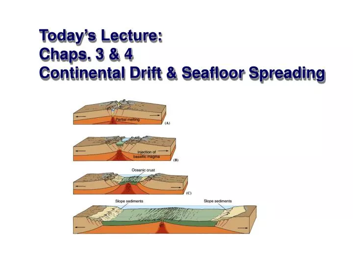
Concept of Seafloor Spreading In 1959, Princeton University Professor Harry Hess proposed: • Ocean ridges are positioned above mantle upwellings, which cause the seafloor to spread, like a conveyor belt. • Magma replaces seafloor as it moves away, creating new oceanic crust. • Deep ocean trenches mark locations where oceanic crust dives back into planet
Seafloor Spreading Hypothesis Tested Magnetic “stripes” discovered on the seafloor! • In 1963, Vine & Matthews connected seafloor spreading & continental drift, using magnetic field reversals recorded by lavas that had been erupted along mid-ocean ridges. • Symmetric patterns (“stripes”) on either side of spreading center (mid-ocean ridge) indicated that the seafloor was moving in opposing directions, away from the central ridge axis and acting as giant “tape recorder” for magnetic reversals. • Changes in width of a given stripe indicated changes in the rate of seafloor spreading. • Rocks of the seafloor could be assigned an age using radiometric dating methods and spreading rates calculated.
Next Time: Plate boundaries Three Margin Types: • Divergent boundaries • Convergent boundaries • Transform fault boundaries