Download
1 / 13
130 likes | 237 Views
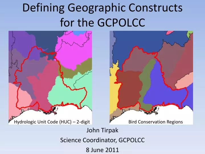
Defining Geographic Constructs for the GCPOLCC. John Tirpak Science Coordinator, GCPOLCC 8 June 2011. Hydrologic Unit Code (HUC) – 2-digit. Bird Conservation Regions. Outline. Orientation Background and Problem Potetnial Solution Identify Geographic Constructs Process and Alternatives

E N D
Defining Geographic Constructs for the GCPOLCC John Tirpak Science Coordinator, GCPOLCC 8 June 2011 Hydrologic Unit Code (HUC) – 2-digit Bird Conservation Regions
Outline • Orientation • Background and Problem • Potetnial Solution • Identify Geographic Constructs • Process and Alternatives • Requested Action
Geographic Constructs • Artificial boundaries that may reflect natural or artificial geographic features
Essence of the Problem • How do we deconstruct the huge 180-million acre GCPOLCC geography into more manageable units that allow us to think and work effectively across the LCC? • How do we eat the elephant?
GCPOLCC Geomatics Working Group • Identify ideal characteristics of a construct • Evaluate alternative constructs • Make recommendations to Steering Committee
GCPOLCC Geomatics Working Group • Identify ideal characteristics of a construct • Meaningful • Used • Manageable • Hierarchical
Geographic Constructs • Evaluate alternative constructs • Reference • Political • Organizational • Edaphic • Ecoregional • Terrestrial • Aquatic Geology Hydrologic Unit Code (HUC) – 2-digit Omernik Level I USFWS USGS NRCS USFS BLM NPS Hydrologic Unit Code (HUC) – 4-digit Bird Conservation Regions UTM Zones Joint Ventures Omernik Level 2 Omernik Level 3 Hydrologic Unit Code (HUC) – 8-digit
GCPOLCC Geomatics Working Group • Identify ideal characteristics of a construct • Meaningful • Used • Manageable • Hierarchical
Recommendations • Terrestrial systems • Use BCRs as base level • Gulf Coast exception • 5 subunits Bird Conservation Regions
Recommendations • Terrestrial systems • Use BCRs as base level • Gulf Coast exception • 5 subunits • Aquatic systems • Use HUC2 • 8 subunits Hydrologic Unit Code (HUC) – 2-digit
Recommendations • Terrestrial systems • Use BCRs as base level • Gulf Coast exception • 5 subunits • Aquatic systems • Use HUC2 • 8 subunits • Overlaps and slivers • No wholesale changes • Work with other LCCs to identify a solution Hydrologic Unit Code (HUC) – 2-digit
Requested Action • “Recommendations from the GCPOLCC Geomatics Working Group to utilize BCR boundaries as geographic constructs for terrestrial systems and HUC2 boundaries as geographic constructs for aquatic systems will be presented to the Interim Steering Committee for approval”