Download
1 / 27
280 likes | 465 Views
The McKinstry Creek & Riparian Area NYSDOT Rt. 219 Mitigation Project Analysis. University at Buffalo Engineering for Ecosystem Restoration Summer Workshop Series 2011 Workshop 2 Stream Restoration, Hydraulic Structure and Bioengineering Design June 13-17, 2011. Mitigation Planning.

E N D
The McKinstry Creek & Riparian Area NYSDOT Rt. 219 Mitigation ProjectAnalysis University at Buffalo Engineering for Ecosystem Restoration Summer Workshop Series 2011 Workshop 2 Stream Restoration, Hydraulic Structure and Bioengineering Design June 13-17, 2011
Mitigation Planning Assessment Conceptual Design Final Design Construction Mitigation Monitoring
NYSDOT Region 5 - Route 219 Extension Stream Mitigation Projects • McKinstry Creek • 2200-feet Channel Realignment and Riparian Restoration 2007
Lake Erie NYS Watershed Map (NYSDEC) Cattaraugus Creek Watershed NYSDEC Lake Erie Basin
Research Field Assessment Data Analysis Scoring QA/QC Conceptual Planning/Design Final Design Review Specification Project Planning Contract Services Procurement Construction Oversight Regulatory Compliance Monitoring Lessons Learned Integrated Planning – Assessment, Design andRegulatory Compliance
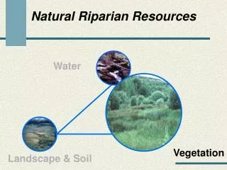
Water Budget Volume Velocity Quality Hydraulics Geology Agronomy Anthropogenic Stressors Vegetation Form Density Complexity Stability Nativity Stream Dynamics, Ecological Associations and Physical Energy
Stream Visual Assessment Protocol • Stream Type • Reach Descriptions • Scoring Descriptions National Water and Climate Center (NWCC) Technical Note 99–1 http://www.nrcs.usda.gov/technical/ECS/aqatic/svapfnl.pdf
SVAP Application • Data Research and Review • Existing, Historical, Pre-Settlement, Anecdotal • Preliminary Field Assessment • Calibrate SVAP • SVAP Field Assessment • QA/QC
SVAP Environmental Conditions • Landscape Position • Soils • Hydrology • Geology • Channel Morphometry • Erosion • Sediment Loading • Riparian Ecological Characterization • Flora and Faunal Surveys and Species Associations
SVAP Typical Results Reach A-1 SVAP Data Sheet Summary Parameter and Result • Dominant Land Use Forest/Successional Shrubland • Stream Length Assessed 378 feet • Bankfull Width 31.5 feet • Water Depth 2-4 inches • Maximum Bankfull Depth 2 feet • Flood-prone Width 40 feet • Dominant Substrate cobble • Pool/Riffle/Run Ratio 12:40:48 • Gradient .29 • Sinuosity Occasional bends • Rosgen Stream Type F3
Packard Bank Revetment/Yard Protection Vinca minor groundcover
The Problem: Expansion of State expressway will impact wetlands. Client required to perform mitigation projects to improve fish habitat in two creeks. The Solution: Use the HEC-RAS hydraulics model Predict low flow depths (fish passage); flood inundation area (100 year flood); sediment scour and sediment stability Use the SWAT model and Bank Stability model to predict overland runoff and bank erosion sediment loads Use the HEC-RAS SIAM module to predict sediment scour, deposition, and equilibrium Hydraulic Modeling NYSDOT - McKinstry Creek, Mansfield Creek
Protocol Stream Type Regional Classification Reach Descriptions Scoring Descriptions Assessment Parameters Channel Form and Condition Hydrologic Alteration Riparian Zone Bank Stability Invasive Species Nutrient Enrichment Barriers to Fish Movement In-Stream Fish Cover Pools Invertebrate Habitat SVAP Review
In Channel W:D Sinuosity Structure LWD Energy Dissipation features Off Channel Bank Instability Access Cattle/Equipment PFRs Riparian Corridor Encroachment Floodplain Disconnect Wetland Hydrology Invasive Plant Species SVAP Findings