Download
1 / 17
170 likes | 309 Views
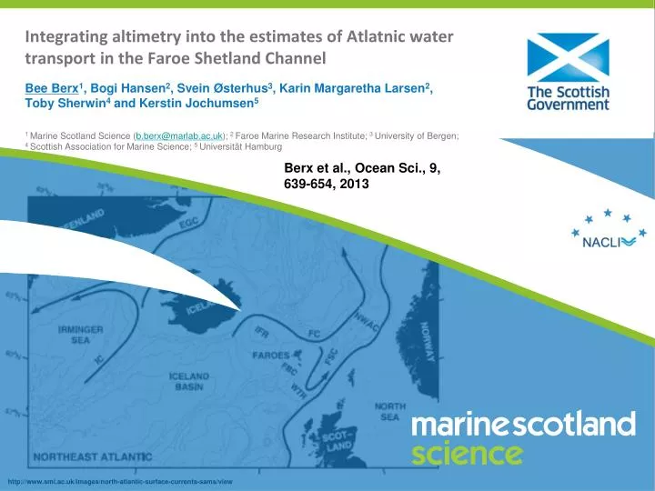
Integrating altimetry into the estimates of Atlatnic water transport in the Faroe Shetland Channel. Bee Berx 1 , Bogi Hansen 2 , Svein Østerhus 3 , Karin Margaretha Larsen 2 , Toby Sherwin 4 and Kerstin Jochumsen 5

E N D
Integrating altimetry into the estimates of Atlatnic water transport in the Faroe Shetland Channel Bee Berx1, Bogi Hansen2, Svein Østerhus3, Karin Margaretha Larsen2, Toby Sherwin4 and Kerstin Jochumsen5 1 Marine Scotland Science (b.berx@marlab.ac.uk); 2 Faroe Marine Research Institute; 3 University of Bergen; 4 Scottish Association for Marine Science; 5 Universität Hamburg Berx et al., Ocean Sci., 9, 639-654, 2013
Incorporating altimetry in transport estimates The assumption of geostrophy allows us to convert sea level height measurements into current speeds. http://www.seos-project.eu/modules/oceancurrents/oceancurrents-c06-s02-p01.html SEOS Project
Estimating average transport of AW • Define the AW velocity in the ADCP data as “surface 325m” • Correlate monthly ADCP velocities with SSH difference • Calculate mean AW velocities from altimetry in all available months • Adjust geostrophic profiles from mean temperature & salinity in surface 325m equals altimetry-adjusted AW velocities
Average volume, relative heat and salt transports in the FSC Compared to the total transport of AtlatnicWater across the GSR = 7.0 Sv
Obtaining monthly estimates of AW Transport: 1. ADCP-based • ADCP sites given “associated widths” • Define AW layer as mean depth of 5°C isotherm • Use average altimetry-adjusted velocities at the boundaries • Depending on period, either 4 or 7 ADCPs across ~150km wide section
Obtaining monthly estimates of AW Transport: 2. altimetry-based Builds on two assumptions: • Vertical-average AW-velocity is proportional to the surface • The product of (1) with the depth of AW is approx. constant throughout the section. • Investigated these assumptions with ADCP data • Adjusted the altimetry-based estimate so the time series mean equals the long-term average calculated previously
Seasonal cycle in volume transport Seasonal amplitude of Atlantic water transport in FSC ~ 0.7-0.9 Sv This is ~ 25% of the average transport Maximum transport in winter-time, lowest transport in summer. Different amplitude based on calculation method
Transport of Atlantic Water in the FSC 1992-2012 No long term trend !
Conclusions • Combined water property observations (Temperature and Salinity) with current meter and sea elevation observations to estimate transport of Atlantic water through the FSC. • On average 2.7±0.5 Sv is transported into the Nordic Seas • Net volume transport shows consistent seasonality: maximum Dec-Jan, and amplitude of 0.7 Sv. • No significant trend in volume transport between 1992 and 2011. • We have observed increases in temperature and salinity, and may therefore expect trends in relative heat and salt transports (but difficult to verify statistically based on this time series). • Currently studying whether less variable observations can be made in an area to the south-west of the FIM section
2014 Initiatives close to NACLIM in the FSC Brahan HF Radar Demonstration and end-user partners UK Ocean-Shelf Exchange Study
Thank you. The research leading to these results has received funding from the European Union 7th Framework Programme (FP7 2007-2013), under grant agreement n.308299 NACLIM www.naclim.eu