Download
1 / 11
110 likes | 189 Views
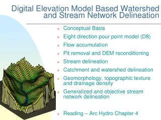
HMS Preprocessor: Incorporating Watershed Parameters. Elizabeth Bristow CVEN 689 April 14, 2003. Project Definition. Improve ArcGIS 8 preprocessor for HMS Create watershed model based on DEM Optional Inputs: NRCS Curve Number shapefile Land use and soil type shapefile

E N D
HMS Preprocessor: Incorporating Watershed Parameters Elizabeth Bristow CVEN 689 April 14, 2003
Project Definition • Improve ArcGIS 8 preprocessor for HMS • Create watershed model based on DEM • Optional Inputs: • NRCS Curve Number shapefile • Land use and soil type shapefile • Green & Ampt parameters • others
Background • CRWR-PrePro • Very complete model of watershed • Avenue-based • Works with ArcView 3.2
Background • PrePro2002 • Visual Basic-based • Works with ArcGIS 8 • Less complete model of watershed • Key difference: Does not calculate watershed parameters
Project Scope • Develop addition to PrePro2002 • Calculate necessary parameters: • Loss Rate • Watershed Routing • Baseflow • Reach Routing
Process • No set series of events • Allows user to choose necessary events • User selects desired watersheds or streams • User chooses desired process
Direct Calculation • User inputs shapefiles or grids with desired parameters • May input components of desired parameter • Program determines average value • Writes average value to attribute table • User may repeat process with other parameters or watersheds
Parameter Input • Some parameters not strictly dependent on spatial data • User may input these directly to attribute table • May also input indirectly through user interface
Why Input Parameters? • Saves time: • Allows user to automate process • May change parameters for more than one feature at a time • Allows tabular input
Creation of HMS Model • Program writes attributes to HMS Basin text file • User opens model in HMS for further analysis