Download
1 / 22
220 likes | 442 Views
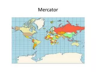
Mercator. Population. Peters Equal Area Map. Pacific Centered Equal Area. Electoral College. Human Development Index. Sources and Sample Lessons. National Council for Geographic Education: - http://www.ncge.org http://www.ncge.org/resources/lessons/submitted/RebuildNewOrleans.pdf.

E N D
Sources and Sample Lessons • National Council for Geographic Education: - http://www.ncge.org • http://www.ncge.org/resources/lessons/submitted/RebuildNewOrleans.pdf
National Geographic • http://www.nationalgeographic.com/
Washington Post • www.washingtonpost.com
BBC News Country Profiles • http://news.bbc.co.uk/2/hi/country_profiles/default.stm
Geography: Human/Cultural and Physical • All Encompassing Discipline Within Social Sciences: history, economics, anthropology, psychology, politics, conflict, agriculture, climate, current events, sociology, religion, science, etc. • Geography Deals With Facts, Culture, Opinion, and Perspective: One of the most important tasks of a geography teacher is to encourage students to see things from various perspectives and to introduce students to concepts, places, and people that they are unfamiliar with: • Ex: Cultures, Environmental Issues, The Way We Look At The World, Maps, etc
Ideas for Teaching: • Looking at things from another’s perspective: The Sacred Rac (1st Day Activity?) • Population/Economics/Poverty • See Handout • Impact of resources/ climate, etc. on population growth, jobs, standard of living, food, etc. • If the world were a village – rich/poor gap • Health Issues
Migration • Brainstorm in Groups: • Who, why, where, do people migrate? • Common views/perceptions of migration and migrants? • Perceived pros and cons of migration. Economy, Culture, etc. • Read In Groups: • Account of A Migrant • Account of A “Coyote” • Account of an Anti-Immigrant Voice • Account of a Pro-Immigrant Voice • Discuss As Group: Present Findings, Re-Address Questions
Colonization/Politics of Borders/Conflict • Who, why, where? • What resources were exploited? • How has this affected the colonized region economically, politically, socially, ethnically, culturally, etc? • What is the legacy of colonization? Language, education, conflict, etc.? • What role do environment, resources, borders, etc. play in conflict between nations? • Have students research current conflicts and/or conflicts throughout history.
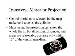
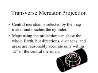
MAPS • Uses: reference, location, distance, topography, resources, etc. • Cartography: Science of Projection • Difficulty of creating a perfect projection • Distortion – Have students draw something on a tennis ball and then cut the tennis ball along the seams to note difficulty of making a sphere flat • Look at various types of projections: Pros and Cons • Politics of Map Making: • Bias: land size, color usage on maps for political statements, borders, etc. • Have students look at maps throughout history to try to figure the nationality, historical era, etc. of the map makers – note the subjectivity of map making • Mental Mapping and Map Tests: • 3. “Map Scraps” – see website - • http://www.ncge.org/resources/geoclub/activities/first_month_activites.pdf • Students get picture of detailed map on the borders of several states or countries – students must figure out what countries and states and answer certain questions using reference materials and by looking for clues via landmarks, rivers, mountains, cities, and other things that are listed.
Teaching About Natural Disaster, Climate Change, Environmental Determinism: • Hurricane Katrina: Should New Orleans Be Rebuilt? http://www.ncge.org/resources/lessons/submitted/RebuildNewOrleans.pdf • Read Differing Points of View: Environment, Economy, etc. • Graphic Organizer • Discuss • Write a response • Other examples of human technology vs. natural/environmental limitations? • Weather, Water, etc. • Pick An Area You Would Like To Live In United States (or World) (other than own State): Why is this a good place? • Climate and Weather • Land, Water, Resources, Sustainability, Natural Disasters, Food, Jobs, Population, etc. – Possible pros and cons of life in this location – is this location sustainable in the long run? • How Does Environment/Climate Impact Culture: • Look at a particular culture: customs, foods, festivals/celebrations, religious expressions, etc. • How is your own culture impacted by environment and climate?
What’s In A Name? Place-names • Have students research the history of places, road names, townships, etc. • Is there a relationship between the environment or history and the name?
Sources • 1. PBS • 2. National Geographic • 3. NCSS • 4. National Council for Geographic Education • 5. BBC News • 6. https://www.cia.gov/library/publications/the-world-factbook/ • 7. United Nations • 8. Newspapers and Periodicals: Washington Post, NY Times, The Economist, • 9. Atlases • 10. odtmaps.com – variety of maps available • 11. www.learner.org.