Download
1 / 15
230 likes | 629 Views
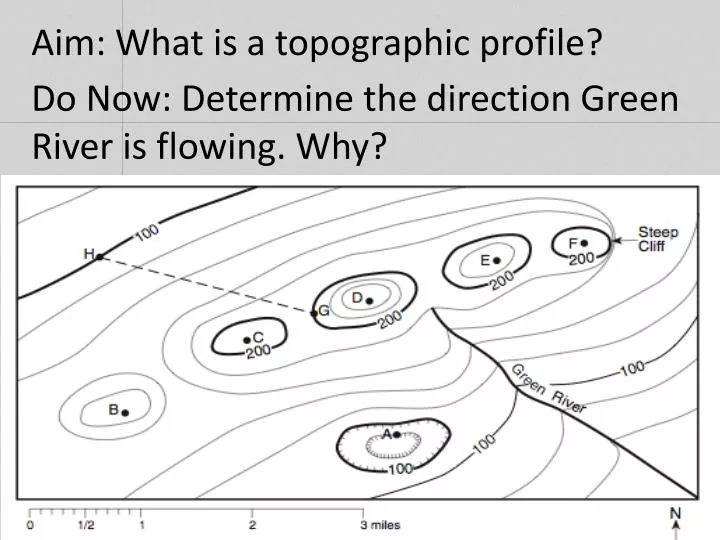
Aim: What is a topographic profile?. Do Now: Determine the direction Green River is flowing. Why? . Topographic Profiles. Topographic maps show the elevation or vertical distance above sea level of the surface of Earth. Topographic profile is a side view of an area. .

E N D
Aim: What is a topographic profile? Do Now: Determine the direction Green River is flowing. Why?
Topographic Profiles • Topographic maps show the elevation or vertical distance above sea level of the surface of Earth. • Topographic profile is a side view of an area.
From the June 2007 NYS Regents Construct a topographic profile from D to E
Step 1 • Understand the contour interval. Contour Interval = 10m (in the legend)
Step 2 • Get a sheet of paper and line it parallel to the line D-E line and mark them.
Step 3 • Put a small line next to each contour line it passes (do not mark the river).
Step 4 • Enter each contour interval value next to each line:
Step 5 • On the answer sheet, be sure that the graph is properly labeled with elevation as the dependent and distance as the independent variables.
Step 6 • Place paper with the marked D-E line on the graph. D and E must match along the x-axis.
Step 7 • Mark the graph at the proper elevations (use a straight edge for accuracy).
Step 8 • Connect the lines. The profile must not go under the 10m mark for the Creek.
In what direction is Amethyst River and Copper Creek flowing? N
Summary (based on the diagram) What is the elevation of A, B, C, and M? What is the maximum elevation of the hilltop between letters C and D? What are hachure marks? Why are they useful on a map? List the steps to produce a topographic profile.