Download
1 / 18
180 likes | 335 Views
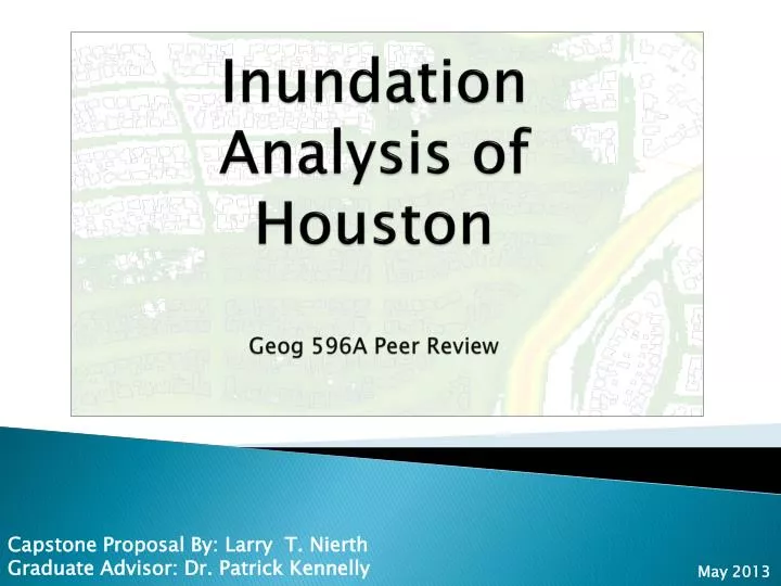
Inundation Analysis of Houston. Geog 596A Peer Review. Capstone Proposal By : Larry T. Nierth Graduate Advisor: Dr. Patrick Kennelly. May 2013. Presentation Outline & Topics . Background Information Goals and Objectives Methodology Anticipated Project Results Project Timeline

E N D
Inundation Analysis of Houston Geog 596A Peer Review Capstone Proposal By: Larry T. Nierth Graduate Advisor: Dr. Patrick Kennelly May 2013
Presentation Outline & Topics • Background Information • Goals and Objectives • Methodology • Anticipated Project Results • Project Timeline • Future Project Use • GEOG 596A • Larry T. Nierth
Background information: • Existing websites for flooding information • What information would be helpful that is not currently available? Vs. Raster Polygon Floodway • GEOG 596A • Larry T. Nierth
Goals and Objectives: • Determine flood depths and flooded percentages of all effected parcels in the study area Water Depth Flooded 100% • GEOG 596A • Larry T. Nierth
Goals and Objectives: • Generate a map set of the findings • GEOG 596A • Larry T. Nierth
Goals and Objectives: • Incorporate 3D models of the floods for visualization Inundation Water Depth • GEOG 596A • Larry T. Nierth
Goals and Objectives: Publish the inundation data online while enabling crowd sourcing for citizens of Houston to input their own observations • GEOG 596A • Larry T. Nierth
Methodology: • Finalize study area locations • GEOG 596A • Larry T. Nierth
Methodology: • Generate raster inundation grids in ArcGIS with Hazus-MH for 100, 500, and 1,000 year flood event scenarios • 3-meter resolution • inundation rasters • GEOG 596A • Larry T. Nierth
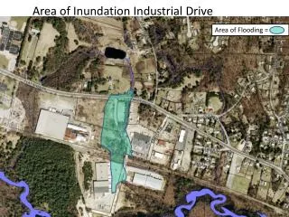
Methodology: Determine parcels effected for each scenario, percent total of each parcel’s area effected, and their actual MAX inundation value. Max depth: 1.13” 1,316 SQFT. 3,713 SQFT. Parcel is 74% Flooded • GEOG 596A • Larry T. Nierth
Methodology: • Aggregate inundation totals by land use code and generate maps summarizing the findings. Average Single- Family Residential flood depth for 100 yr. flood? Sum total of all flooded Commercial property for 500 yr. flood? What land use type Is the most flooded in each scenario? • GEOG 596A • Larry T. Nierth
Methodology: • Create Adobe Flex application using ArcGIS Server and CloudBuilder, hosted in the cloud with Amazon. • Allow crowd sourcing of citizen observations by enabling editable a point feature web service within the web map application. • Citizens will be able to access the website and search • for their address of enter coordinates of their homes or • businesses. • After the desired location is found, they can add a point • directly onto the map and enter the amount of inundation observed (in inches). • GEOG 596A • Larry T. Nierth
Anticipated Project Results: • Inform City of Houston citizens about flood locations and depths though increase awareness of what can really happen in these scenario based floods (including presentation at Esri UC). • Enable Houston residents to participate directly by adding their own observations to editable feature services in the inundation web application. • Gather data over time of actual flood observations from citizen inputs for use in further modeling and targeting of infrastructure improvement projects. • GEOG 596A • Larry T. Nierth
Project Timeline • GEOG 596A • Larry T. Nierth
Project Timeline Continued • GEOG 596A • Larry T. Nierth
Future Project Use: • Over time, the data taken in from citizens will allow us to continuously fine tune target areas for improvement. • Crowd sourced data will be compiled to continuously get inundation averages of flood-prone areas. • Project area expansion • Scripting and automation GEOG 596A Larry T. Nierth
Acknowledgements: • Dr. Patrick Kennelly • Department of Geography, Penn State University • Sterling Quinn, MGIS • Department of Geography, Penn State University GEOG 596A Larry T. Nierth
Questions? GEOG 596A Larry T. Nierth