Download
1 / 22
220 likes | 343 Views
Plate Tectonics. Litoshpere ..Crust & Rigid upper mantle Astenosphere – weak and capable of flow Oceanic and Continental crust Oceanic – 6-12 km thick, dense heavy, basalt, SIMA Continental – 40-60km thick, less dense, granite, SIAL

E N D
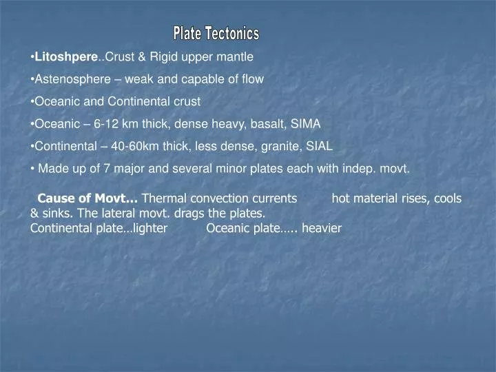
Plate Tectonics • Litoshpere..Crust & Rigid upper mantle • Astenosphere – weak and capable of flow • Oceanic and Continental crust • Oceanic – 6-12 km thick, dense heavy, basalt, SIMA • Continental – 40-60km thick, less dense, granite, SIAL • Made up of 7 major and several minor plates each with indep. movt. • Cause of Movt… Thermal convection currents hot material rises, cools & sinks. The lateral movt. drags the plates. • Continental plate…lighter Oceanic plate….. heavier
Continental Drift.. • Wegener 1912.. • Pangaea.. One super continent. 225 million yrs ago • 200m yrs ago split…. • Laurasia.. Europe, Nth America & Asia. • Gondwanaland.. Sth. Am, Africa, India, Australia, Antartica. • 1963 (Harry Hess) Theory accepted… discovered Mid Atlantic Ridge which was proof of ocean floor spreading. • Proof: Continental Fit .. Like a jigsaw, • Matching fossils; • matching rocks (structure & type) • Mt. ranges…Appalachion Mts of U.S. & Caledonian of Irl & Br. • both fold mts. • Matching glacial deposits in S. America, Africa and Australia • Sea floor spreading and Age of ocean floor: oil drilling shows edge of ocean rock 200m yrs older than the Mid Atlantic ridge. • Satellite measurements show Sth Am. & Africa moving 2.5cm apart each year.
Plate Boundaries: Constructive • Diverge.. Move apart causes cracks fills with magma. • Result: (i) New ocean floor… • (ii) Mt. range/ridge e.g. Mid Atlantic Ridge … cont. move apart. • (iii) Islands form…. e.g. Iceland. • East African Rift Valley • 6000km long • 2 new African plates – Nubian Plates & Somali Plates • Red Sea is a part of the Rift Valley • Western and eastern Rift Valley • Contains some of the deepest lakes in the world • Lake Tanganyika – 1,470 metres deep • Lake Victoria – 2nd largest lake in the world
Africa Eastern Africa- divergent plates Eurasian & African plates collided 25m yrs ago -- fractures. Magma plumes warped the surface upwards, making it brittle. It fractured and moved apart. This gave rise to 3 active rift zones Gulf of Eden East African Rift Red Sea The Arabian Peninsula split off from Africa & opened up the Red sea and the Gulf of Eden. East Africa in 50m yrs will detach itself and form a new continent & sea.
Destructive • B) Converge.. Meet one plate sinks = subduction zone…. Crust destroyed. • Oceanic & Oceanic … older heavier plate descends under lighter plate • (i) Narrow trench e.g Mariana Trench where Pacific & Phillipinnesplates meet. • (ii) Volcano … Crust melts & produces magma. • (iii) Island arcs…hotspots as magma melts the crust…plates move eg. Japan. • (iv) Earthquakes… caused by collision stress
2.Oceanic & Continental… collide oceanic sinks Result trench, volcano, earthquake, E.g. Andes Mts. (Sth. Am.) • Continental & Continental….. Collide buckle & fracture. • Result Mts. & earthquakes e.g. Himalayan mts. Where Indian and Eurasian plates met…. Contain sea fossils… proof that they were once in the sea. Passive Plates slide past each other (sheer) -- (i) transform fault… San Andreas Fault… Pacific & American plates. (ii) Earthquakes
Constructive • Rising current of magma splits continent • Move apart – water rushes in – ocean • Mid-ocean ridge above plume of magma • Volcanoes along ridge • Some islands e.g. Iceland might appear
Destructive • Ocean-ocean – subducted plate melts and rising magma creates line of volcanoes called island arc • Ocean-continent – heavier ocean plate sinks, buckles and folds, islands, extinxt volcanoes pushed against continent edge making it wider • Sinking magma creates volcanoes
Continent- continent- Large Fold Mts • Passive- Mostly along mid ocean ridges • Sometimes on dry land – San Andreas fault • Earthquakes
Ireland on the move Irelands past shows evidence of desert & tropical climates. Geology: Croagh Patrick, Mayo Quartzite… Sugarloaf, Wicklow formed at opposite ends of an ocean. Limestone…. Central plain - formed at bed of tropical ocean. Fold Mts. Nth west they run sw/ne Munster they run e/w Why? Different rock types. Plates have drifted from 30˚ south of equator to 54˚ north ... Drifted 9,000 miles in 500 million years.
Million Years ago • 400 Nth & sth Irl join(20˚ sth) …. Causing folding and faulting. • 380 Move Nth… desert area… only nth. section above sea level • Erosion & deposition in sth. - old red sandstone, Munster • Rise in sea level- Irl. submerged in tropical seas. • Result in limestone of the Burren. • European & African plates collide - Fold mts. Of Munster. • Erosion & marine sediments form into oil & gas. • 100 Uplift… land rises above sea level-- more limestone & chalk • 65 Volcanic bursts & rifting-- detach from America & form Atlantic ocean & Antrim Plateau.