Download
1 / 26
260 likes | 397 Views
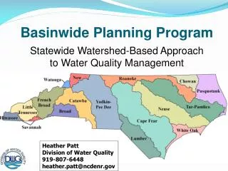
Utilizing a Basinwide Approach for the North Carolina Flood Mapping Program. John Dorman, Program Director, NC CTS Flood Mapping Program Gib Jones, P.E., Dewberry & Davis LLC. Background. Why North Carolina Is Undertaking This Project. NC vulnerability to hurricanes and flooding

E N D
Utilizing a Basinwide Approach for the North Carolina Flood Mapping Program John Dorman, Program Director,NC CTS Flood Mapping Program Gib Jones, P.E., Dewberry & Davis LLC
Why North Carolina Is Undertaking This Project • NC vulnerability to hurricanes and flooding • 14 federally declared disasters since 1989 • Hurricane Floyd damages = $3.5 billion • 4,117 uninsured/under-insured homes destroyed as result of Hurricane Floyd • Accurate, up-to-date flood hazard information crucial to protect NC livesand properties
Why North Carolina Is Undertaking This Project (Continued) • Hurricane Floyd revealed flood hazard data and map limitations • Age of North Carolina FIRMS • 55% at least 10 years old • 75% at least 5 years old • FEMA’s mapping budget is finite • NC receives only one updated flood studyfor one county per year • Many counties and communities lack resources to take on this responsibility
North Carolina CTS Flood Mapping Program • Cooperating Technical State (CTS) partnership with Federal Emergency ManagementAgency (FEMA) • State ownership and responsibility for Flood Insurance Rate Maps (FIRMs)
Mapping Products • High-resolution topographic dataand accurate Digital ElevationModels (DEMs) • Engineering studies • Countywide digital FIRMs • State-of-the-art, dynamic Information Technology (IT) infrastructure • Real-time flood forecasting and inundation mapping capability
Three Phases to Mapping Project Phase I—bluePhase II—goldPhase III—green
Phase I — Eastern Six River Basins • Addressing eastern six basins first • Basins most affected byHurricane Floyd • Comprise approximately halfof State
Phase I — Eastern Six River Basins • Affect 48 counties and 334 incorporated municipalities (in whole or in part) • Encompass approximately 21,200 linear miles of streams and rivers • Flood hazard mapping for remaining 11 basins to be discussed with General Assembly in 2001
Project “Scoping” • Meetings held with every community in 6 eastern basins • Their needs synthesized into basinwide objectives • Basinwide work plans developed
Flood Map Production Process • Topographic Data Collection and DEM Creation • Hydrologic & Hydraulic (H&H) Analyses • DFIRM Production • Community Review and Due Process
Two Study Contractors • Each to perform • Topographic data collectionand DEM production • H&H Analyses • DFIRM production • Work broken out by basin
Topographic Data Collectionand DEM Creation • Includes • LIDAR surveys • Field surveys of structures and channels • Automated and manual post-processing • DEM creation • Conducted on a basinwide approach • Efficiency of scale realized in surveying large geographic areas
Example: Status of Bare Earth DEM Creation Topographic Data Collectionand DEM Creation
Engineering Analyses • Hydrology and stream hydraulicsdo not follow corporate boundaries • Set up H&H models using basinwide approach • Allows large areas to be study contiguously • Minimizes discontinuities and mismatches
Digital FIRM Production • “Carve” up data into countywide maps • Countywide maps more user friendly • Corresponds to community-based approach to floodplain management • Merge data for counties in more than one basin
Community Review andDue Process • Community meetings held oncounty or basinwide basis • Due Process • 90-day appeal period • Evaluate and resolve community comments and concerns • Update community ordinances • Printing and distribution of maps
Multi-Basin Counties • Many counties are in more than one basin • Basins will be completed at different times Insert figure with schedule for different basins
Multi-Basin Counties Tar-Pamlico Basin Neuse Basin
Processing Multi-Basin Counties • Process different portions of county separately • Produce separate preliminary maps • Separate due process • Merge different portions after all portions have gone through due process • Prioritize multi-basin counties
Preliminary Map for Multi-Basin County 657 LumberRiver Basin 658 658 SMITHVILLE ROAD 659 660 BLADEN COUNTYAND INCORPORATED AREAS Basin Divide Cape Fear River Basin “Preliminary revised flood hazard information not yet available for Cape Fear Basin. Please refer to effective FIRM.” FIRM panel neatlines
6 month compliance period 90-day appealperiod (Cape Fear) 90-day appeal period (Lumber) Effective Countywide FIRM 1stPublicNotice 2ndPublicNotice 1stPublicNotice 2ndPublicNotice PreliminaryIssued(Lumber) FinalMeeting(Lumber) End ofAppeal Period(Lumber) Preliminary Issued(Cape Fear) FinalMeeting(Cape Fear) End ofAppeal Period(Cape Fear) FinalElevationDetermin. 10-12-01 10-26-01 12-12-02 12-26-02 9-28-01 10-5-01 1-10-02 8-28-02 9-6-02 9-13-02 9-27-02 2-28-03 4-25-03 Timeline for Multi-Basin County
Utilizing a Basinwide Approach for the North Carolina Flood Mapping Program QUESTIONS? ? ? ? ?